 Introduction Introduction
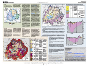
The Columbia Plateau Regional Aquifer System (CPRAS) covers approximately 44,000 square miles of northeastern Oregon, southeastern Washington, and western Idaho. The area supports a $6 billion per year agricultural industry, leading the Nation in production of apples and nine other commodities (State of Washington Office of Financial Management, 2007; U.S. Department of Agriculture, 2007). Groundwater availability in the aquifers of the area is a critical water-resource management issue because the water demand for agriculture, economic development, and ecological needs is high.
The primary aquifers of the CPRAS are basalts of the Columbia River Basalt Group (CRBG) and overlying basin-fill sediments. Water-resources issues that have implications for future groundwater availability in the region include (1) widespread water-level declines associated with development of groundwater resources for irrigation and other uses, (2) reduction in base flow to rivers and associated effects on temperature and water quality, and (3) current and anticipated effects of global climate change on recharge, base flow, and ultimately, groundwater availability.
As part of a National Groundwater Resources Program, the U.S. Geological Survey began a study of the CPRAS in 2007 with the broad goals of (1) characterizing the hydrologic status of the system, (2) identifying trends in groundwater storage and use, and (3) quantifying groundwater availability.
The study approach includes documenting changes in the status of the system, quantifying the hydrologic budget for the system, updating the regional hydrogeologic framework, and developing a groundwater-flow simulation model for the system. The simulation model will be used to evaluate and test the conceptual model of the system and later to evaluate groundwater availability under alternative development and climate scenarios.
The objectives of this study were to update the hydrogeologic framework for the CPRAS using the available geologic mapping and well information and to develop a digital, three-dimensional hydrogeologic model that could be used as the basis of a groundwater-flow model. This report describes the principal geologic and hydrogeologic units of the CPRAS and geologic map and well data that were compiled as part of the study. The report also describes simplified regional hydrogeologic sections and unit extent maps that were used to conceptualize the framework prior to development of the digital 3-dimensional framework model.
|
Part or all of this report is presented in Portable Document Format (PDF); the latest version of Adobe Reader or similar software is required to view it. Download the latest version of Adobe Reader, free of charge. |

