Scientific Investigations Map 3098
Abstract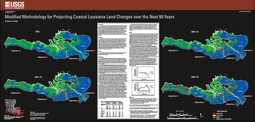
The coastal Louisiana landscape is continually undergoing geomorphologic changes (in particular, land loss); however, after the 2005 hurricane season, the changes were intensified because of Hurricanes Katrina and Rita. The amount of land loss caused by the 2005 hurricane season was 42 percent (562 km²) of the total land loss (1,329 km²) that was projected for the next 50 years in the Louisiana Coastal Area (LCA), Louisiana Ecosystem Restoration Study. The purpose of this study is to provide information on potential changes to coastal Louisiana by using a revised LCA study methodology. In the revised methodology, we used classified Landsat TM satellite imagery from 1990, 2001, 2004, and 2006 to calculate the “background” or ambient land-water change rates but divided the Louisiana coastal area differently on the basis of (1) geographic regions (“subprovinces”) and (2) specific homogeneous habitat types. Defining polygons by subprovinces (1, Pontchartrain Basin; 2, Barataria Basin; 3, Vermilion/Terrebonne Basins; and 4, the Chenier Plain area) allows for a specific erosion rate to be applied to that area. Further subdividing the provinces by habitat type allows for specific erosion rates for a particular vegetation type to be applied. Our modified methodology resulted in 24 polygons rather than the 183 that were used in the LCA study; further, actively managed areas and the CWPPRA areas were not masked out and dealt with separately as in the LCA study. This revised methodology assumes that erosion rates for habitat types by subprovince are under the influence of similar environmental conditions (sediment depletion, subsidence, and saltwater intrusion). Background change rate for three time periods (1990–2001, 1990–2004, and 1990–2006) were calculated by taking the difference in water or land among each time period and dividing it by the time interval. This calculation gives an annual change rate for each polygon per time period. Change rates for each time period were then used to compute the projected change in each subprovince and habitat type over 50 years by using the same compound rate functions used in the LCA study. The resulting maps show projected land changes based on the revised methodology and inclusion of damage by Hurricanes Katrina and Rita. Comparison of projected land change values between the LCA study and this study shows that this revised methodology—that is, using a reduced polygon subset (reduced from 183 to 24) based on habitat type and subprovince—can be used as a quick projection of land loss. |
First posted December 15, 2009 For additional information contact: Part or all of this report is presented in Portable Document Format (PDF); the latest version of Adobe Reader or similar software is required to view it. Download the latest version of Adobe Reader, free of charge. |
Hartley, S.B., 2009, Modified methodology for projecting coastal Louisiana land changes over the next 50 years: U.S. Geological Survey Scientific Investigations Map 3098, 1 sheet, scale 1:750,000.

![]() U.S. Department of the Interior |
U.S. Geological Survey
U.S. Department of the Interior |
U.S. Geological Survey
URL: http://pubsdata.usgs.gov/pubs/sim/3098/index.html
Page Contact Information: GS Pubs Web Contact
Page Last Modified: Thursday, 01-Dec-2016 17:14:51 EST
