Scientific Investigations Map 3118
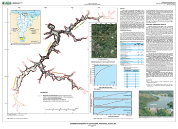
IntroductionLago de Cidra is a reservoir located on the confluence of Río de
Bayamón, Río Sabana, and Quebrada Prieta, in the municipality of Cidra in
east-central Puerto Rico, about 3.0 kilometers northeast of the town of Cidra. The dam is owned and operated by the Puerto Rico Aqueduct and Sewer
Authority (PRASA), and was constructed in 1946 as a 6.54-million-cubic-meter
supplemental water supply for the San Juan metropolitan area. |
First posted August 2010 For additional information contact: Part or all of this report is presented in Portable Document Format (PDF); the latest version of Adobe Reader or similar software is required to view it. Download the latest version of Adobe Reader, free of charge. |
L.R. Soler-López., 2010, Sedimentation Survey of Lago de Cidra, Puerto Rico, August 2007: U.S. Geological Survey Scientific Investigations Map 3118, 1 plate., available at https://pubs.usgs.gov/sim/3118/.

![]() U.S. Department of the Interior |
U.S. Geological Survey
U.S. Department of the Interior |
U.S. Geological Survey
[an error occurred while processing this directive]
URL: https://pubsdata.usgs.gov
Page Contact Information: Contact USGS
Page Last Modified: Thursday, 01-Dec-2016 17:19:38 EST
