Scientific Investigations Map 3134
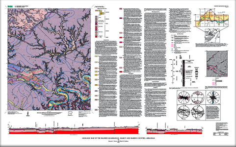
This map summarizes the geology of the Maumee 7.5-minute quadrangle in northern Arkansas. The map area is in the Ozark plateaus region on the southern flank of the Ozark dome. The Springfield Plateau, composed of Mississippian cherty limestone, overlies the Salem Plateau, composed of Ordovician carbonate and clastic rocks, with areas of Silurian rocks in between. Erosion related to the Buffalo River and its tributaries, Tomahawk, Water, and Dry Creeks, has exposed a 1,200-ft-thick section of Mississippian, Silurian, and Ordovician rocks mildly deformed by faults and folds. An approximately 130-mile-long corridor along the Buffalo River forms the Buffalo National River that is administered by the National Park Service. McKnight (1935) mapped the geology of the Maumee quadrangle as part of a larger 1:125,000-scale map focused on understanding the lead and zinc deposits common in the area. Detailed new mapping for this study was compiled using a Geographic Information System (GIS) at 1:24,000 scale. Site location and elevation were obtained by using a Global Positioning Satellite (GPS) receiver in conjunction with a U.S. Geological Survey 7.5-minute topographic map and barometric altimeter. U.S. Geological Survey 10-m digital elevation model data were used to derive a hill-shade-relief map used along with digital orthophotographs to map ledge-forming units between field sites. Bedding attitudes were measured in drainage bottoms and on well-exposed ledges. Bedding measured at less than 2° dip is indicated as horizontal. Structure contours constructed for the base of the Boone Formation are constrained by field-determined elevations on both upper and lower formation contacts. |
First posted October 26, 2010 For additional information contact: Part or all of this report is presented in Portable Document Format (PDF); the latest version of Adobe Reader or similar software is required to view it. Download the latest version of Adobe Reader, free of charge. |
Turner, K.J., and Hudson, M.R., 2010, Geologic map of the Maumee quadrangle, Searcy and Marion Counties, Arkansas: U.S. Geological Survey Scientific Investigations Map 3134, scale 1:24,000.

![]() U.S. Department of the Interior |
U.S. Geological Survey
U.S. Department of the Interior |
U.S. Geological Survey
URL: http://pubsdata.usgs.gov/pubs/sim/3134/index.html
Page Contact Information: GS Pubs Web Contact
Page Last Modified: Thursday, 01-Dec-2016 17:20:05 EST
