Scientific Investigations Map 3136
ABSTRACT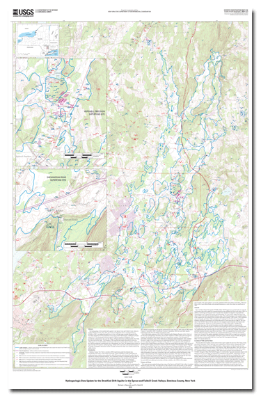
The hydrogeology of the stratified-drift aquifer in the Sprout Creek and Fishkill Creek valleys in southern Dutchess County, New York, previously investigated by the U.S. Geological Survey (USGS) in 1982, was updated through the use of new well data made available through the New York State Department of Environmental Conservation's Water Well Program. Additional well data related to U.S. Environmental Protection Agency (USEPA) remedial investigations of two groundwater contamination sites near the villages of Hopewell Junction and Shenandoah, New York, were also used in this study. The boundary of the stratified-drift aquifer described in a previous USGS report was extended slightly eastward and southward to include adjacent tributary valleys and the USEPA groundwater contamination site at Shenandoah, New York. The updated report consists of maps showing well locations, surficial geology, altitude of the water table, and saturated thickness of the aquifer. Geographic information system coverages of these four maps were created as part of the update process. |
First posted January 28, 2011
For additional information contact: Part or all of this report is presented in Portable Document Format (PDF); the latest version of Adobe Reader or similar software is required to view it. Download the latest version of Adobe Reader, free of charge. |
Reynolds, R.J., and Calef, F.J., III., 2010, Hydrogeologic data update for the stratified-drift aquifer in the Sprout and Fishkill Creek valleys, Dutchess County, New York: U.S. Geological Survey Scientific Investigations Map 3136, 4 sheets, 1:24,000, available at https://pubs.usgs.gov/sim/3136.
Abstract
Introduction
Purpose and Scope
Methods
Locations of Wells and Test Holes
Surficial Geology
Shenandoah Moraine
Outwash Sand and Gravel
Altitude of the water table
Saturated Thickness of the Surficial Aquifer
Summary
Selected References

![]() U.S. Department of the Interior |
U.S. Geological Survey
U.S. Department of the Interior |
U.S. Geological Survey
URL: http://
pubsdata.usgs.gov
/pubs/sim/3136/index.html
Page Contact Information: USGS Publications Team
Page Last Modified: Thursday, 01-Dec-2016 17:21:11 EST
