U.S. Geological Survey Scientific Investigations Map 3144
Summary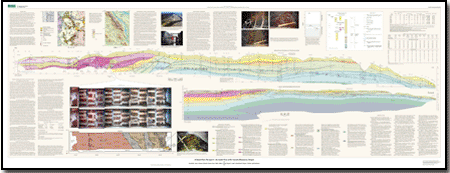
The Tualatin Mountains form a northwest-striking ridge about 350 m high that separates Portland, Oregon, from the cities of the Tualatin Valley to the west. Known informally as the Portland Hills, the ridge is a late Cenozoic anticline, bounded by reverse faults that dip toward the anticlinal axis. The anticline is a broad, open fold consisting chiefly of Miocene Columbia River Basalt Group, with remnants of Miocene-Pliocene Troutdale Formation and Pleistocene basalt of the Boring Volcanic Field on the flanks of the anticline. Anticlinal structures similar to the Tualatin Mountains are characteristic of the northern Willamette Valley, where the structures accommodate margin-parallel shortening of the Cascadia fore arc. Global Positioning System (GPS) results indicate that the shortening is due to the northward motion of Oregon at several millimeters per year with respect to stable North America. Some of the uplifts may contain active faults, but the structures are poorly exposed and are overlain by thick Pleistocene loess and Missoula flood deposits. Between 1993 and 1998, construction of the 3-mile-long (4500-m-long) TriMet MAX Light Rail tunnel through the Tualatin Mountains provided an unusual opportunity to investigate the geological structure and history of the Tualatin Mountains. This report is a collaborative effort among the tunnel geologists and the U.S. Geological Survey (USGS) to document the geologic story and quantify late Cenozoic and Quaternary deformation rates of the Tualatin Mountains. |
Last modified July 29, 2011
For additional information: This report is presented in Portable Document Format (PDF); the latest version of Adobe Reader or similar software is required to view it. Download the latest version of Adobe Reader, free of charge. |
Walsh, K.P., Peterson, G.L., Beeson, M.H., Wells, R.E., Fleck, R.J., Evarts, R.C., Duvall, Alison, Blakely, R.J., and Burns, Scott, 2011, A tunnel runs through it--An inside view of the Tualatin Mountains, Oregon: U.S. Geological Survey Scientific Investigations Map 3144.

![]() U.S. Department of the Interior |
U.S. Geological Survey
U.S. Department of the Interior |
U.S. Geological Survey
URL: http://pubsdata.usgs.gov/pubs/sim/3144/index.html
Page Contact Information: GS Pubs Web Contact
Page Last Modified: Thursday, 01-Dec-2016 17:21:16 EST
