Scientific Investigations Map 3159
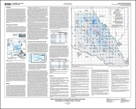
AbstractThe Equus Beds aquifer in southwestern Harvey County and northwestern Sedgwick County was developed to supply water to the city of Wichita and for irrigation in south-central Kansas. Water-level and storage-volume decreases that began with the development of the aquifer in the 1940s reached record to near-record lows in January 1993. Since 1993, the aquifer has been experiencing higher water levels and a partial recovery of storage volume previously lost from August 1940 to January 1993. Measured water-level changes for August 1940 to July 2010 ranged from a decline of 27.25 feet to a rise of 5.04 feet. The change in storage volume in the study area from August 1940 to July 2010 was a decrease of about 93,700 acre-feet and was similar to levels in the 1970s. This storage-volume change represents a recovery of about 161,300 acre-feet, or about 63 percent of the storage volume previously lost between August 1940 and January 1993. The change in storage volume from August 1940 to July 2010 in the central part of the study area, where city pumpage occurs, was a decrease of about 56,000 acre-feet. This represents a recovery of about 98,000 acre-feet, or about 64 percent of the storage volume previously lost between August 1940 and January 1993 in the central part of the study area. It also represents a recovery of about 26,900 acre-feet, or about 32 percent of the storage volume lost between August 1940 and January 2007. Major factors in the recovery in storage volumes seen in the study area and the central part of the study area are increased recharge from greater-than-normal precipitation and planned decreases in city pumpage that are part of Wichita's Integrated Resource Plan; however, part of the recovery may be because city and irrigation pumpage probably decreased in response to greater-than-normal precipitation in the study area. |
First posted May 4, 2011 For additional information contact: Part or all of this report is presented in Portable Document Format (PDF); the latest version of Adobe Reader or similar software is required to view it. Download the latest version of Adobe Reader, free of charge. |
Hansen, C.V., 2011, Status of groundwater levels and storage volume in the Equus Beds aquifer near Wichita, Kansas, July 2010: U.S. Geological Survey Scientific Investigations Map 3159, 1 sheet.

![]() U.S. Department of the Interior |
U.S. Geological Survey
U.S. Department of the Interior |
U.S. Geological Survey
URL: http://pubsdata.usgs.gov/pubs/sim/3159/index.html
Page Contact Information: GS Pubs Web Contact
Page Last Modified: Thursday, 01-Dec-2016 17:22:40 EST
