Scientific Investigations Map 3162
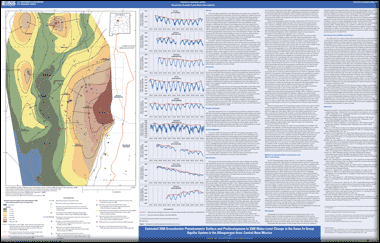
AbstractThe water-supply requirements of the Albuquerque metropolitan area of central New Mexico have historically been met almost exclusively by groundwater withdrawal from the Santa Fe Group aquifer system. Previous studies have indicated that the large quantity of groundwater withdrawal relative to recharge has resulted in water-level declines in the aquifer system throughout the metropolitan area. Analysis of the magnitude and pattern of water-level change can help improve understanding of how the groundwater system responds to withdrawals and variations in the management of the water supply and can support water-management agencies' efforts to minimize future water-level declines and improve sustainability. This report, prepared by the U.S. Geological Survey in cooperation with the Albuquerque Bernalillo County Water Utility Authority, presents the estimated groundwater potentiometric surface during winter (from December to March) of the 2008 water year and the estimated changes in water levels between predevelopment and water year 2008 for the production zone of the Santa Fe Group aquifer system in the Albuquerque and surrounding metropolitan and military areas. Hydrographs from selected wells are included to provide details of historical water-level changes. In general, water-level measurements used for this report were measured in small-diameter observation wells screened over short intervals and were considered to best represent the potentiometric head in the production zone—the interval of the aquifer, about 300 feet below land surface to 1,100 feet or more below land surface, in which production wells generally are screened. Water-level measurements were collected by various local and Federal agencies. The 2008 water year potentiometric surface map was created in a geographic information system, and the change in water-level elevation from predevelopment to water year 2008 was calculated. The 2008 water-level contours indicate that the general direction of groundwater flow is from the Rio Grande towards clusters of production wells in the east, north, and west. Water-level changes from predevelopment to 2008 are variable across the area. Hydrographs from piezometers on the east side of the river generally indicate a trend of decline in the annual highest water level through most of the period of record. Hydrographs from piezometers in the valley near the river and on the west side of the river indicate spatial variability in water-level trends. |
First posted June 24, 2011
For additional information contact: Part or all of this report is presented in Portable Document Format (PDF); the latest version of Adobe Reader or similar software is required to view it. Download the latest version of Adobe Reader, free of charge. |
Falk, S.E., Bexfield, L.M., and Anderholm, S.K., 2011, Estimated 2008 groundwater potentiometric surface and predevelopment to 2008 water-level change in the Santa Fe Group aquifer system in the Albuquerque area, central New Mexico: U.S. Geological Survey Scientific Investigations Map 3162, 1 sheet.
Abstract
Introduction
Purpose and Scope
Acknowledgments
Data Sources
Methods for Estimating Water-Level Contours and Water-Level Change
Hydrographs
Groundwater Flow and Water-Level Changes
References

![]() U.S. Department of the Interior |
U.S. Geological Survey
U.S. Department of the Interior |
U.S. Geological Survey
URL: http://pubsdata.usgs.gov/pubs/sim/3162/index.html
Page Contact Information: GS Pubs Web Contact
Page Last Modified: Thursday, 01-Dec-2016 17:23:06 EST
