Scientific Investigations Map 3176
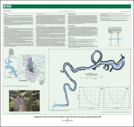
ABSTRACTThe U.S. Geological Survey, in cooperation with the City of Tuscaloosa, conducted a bathymetric survey of Carroll Creek, on May 12–13, 2010. Carroll Creek is one of the major tributaries to Lake Tuscaloosa and contributes about 6 percent of the surface drainage area. A 3.5-mile reach of Carroll Creek was surveyed to prepare a current bathymetric map, determine storage capacities at specified water-surface elevations, and compare current conditions to historical cross sections. Bathymetric data were collected using a high-resolution interferometric mapping system consisting of a phase-differencing bathymetric sonar, navigation and motion-sensing system, and a data acquisition computer. To assess the accuracy of the interferometric mapping system and document depths in shallow areas of the study reach, an electronic total station was used to survey 22 cross sections spaced 50 feet apart. The data were combined and processed and a Triangulated Irregular Network (TIN) and contour map were generated. Cross sections were extracted from the TIN and compared with historical cross sections. Between 2004 and 2010, the area (cross section 1) at the confluence of Carroll Creek and the main run of LakeTuscaloosa showed little to no change in capacity area. Another area (cross section 2) showed a maximum change in elevation of 4 feet and an average change of 3 feet. At the water-surface elevation of 224 feet (National Geodetic Vertical Datum of 1929), the cross-sectional area has changed by 260 square feet for a total loss of 28 percent of cross-sectional storage area. The loss of area may be attributed to sedimentation in Carroll Creek and (or) the difference in accuracy between the two surveys. |
First posted September 8, 2011
For additional information contact: Part or all of this report is presented in Portable Document Format (PDF); the latest version of Adobe Reader or similar software is required to view it. Download the latest version of Adobe Reader, free of charge. |
Lee, K.G., and Kimbrow, D.R., 2011, Bathymetric survey of Carroll Creek Tributary to Lake Tuscaloosa, Tuscaloosa County, Alabama, 2010: U.S. Geological Survey Scientific Investigations Map 3176, 1 sheet.
Abstract
Introduction
Description of the Study Area
Methods and Data Collection
Bathymetric Contours
Storage Capacities
References Cited

![]() U.S. Department of the Interior |
U.S. Geological Survey
U.S. Department of the Interior |
U.S. Geological Survey
URL: http://pubsdata.usgs.gov/pubs/sim/3176/index.html
Page Contact Information: GS Pubs Web Contact
Page Last Modified: Thursday, 01-Dec-2016 17:23:18 EST
