Scientific Investigations Map 3182
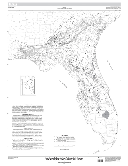
IntroductionThe Floridan aquifer system covers nearly 100,000 square miles in the southeastern United States throughout Florida and in parts of Georgia, South Carolina, and Alabama, and is one of the most productive aquifers in the world (Miller, 1990). This sequence of carbonate rocks is hydraulically connected and is over 3,000 feet thick in south Florida and thins toward the north. Typically, this sequence is subdivided into the Upper Floridan aquifer, the middle confining unit, and the Lower Floridan aquifer. The majority of freshwater is contained in the Upper Floridan aquifer and is used for water supply (Miller, 1986). The Lower Floridan aquifer contains fresh to brackish water in northeastern Florida and Georgia, while in south Florida it is saline. The potentiometric surface of the Upper Floridan aquifer in May–June 2010 shown on this map was constructed as part of the U.S. Geological Survey Floridan Aquifer System Groundwater Availability Study (U.S. Geological Survey database, 2011). Previous synoptic measurements and regional potentiometric maps of the Upper Floridan aquifer were prepared for May 1980 (Johnston and others, 1981) and May 1985 (Bush and others, 1986) as part of the Floridan Regional Aquifer System Analysis. |
First posted November 17, 2011
For additional information contact: Part or all of this report is presented in Portable Document Format (PDF); the latest version of Adobe Reader or similar software is required to view it. Download the latest version of Adobe Reader, free of charge. |
Kinnaman, S.L., and Dixon, J.F., 2011, Potentiometric surface of the Upper Floridan aquifer in Florida and parts of Georgia, South Carolina, and Alabama, May – June 2010: U.S. Geological Survey Scientific Investigations Map 3182, 1 sheet.
Introduction
Potentiometric Surface
Acknowledgments
References Cited

![]() U.S. Department of the Interior |
U.S. Geological Survey
U.S. Department of the Interior |
U.S. Geological Survey
URL: http://pubsdata.usgs.gov/pubs/sim/3182/index.html
Page Contact Information: GS Pubs Web Contact
Page Last Modified: Thursday, 01-Dec-2016 17:23:50 EST
