Scientific Investigations Map 3192
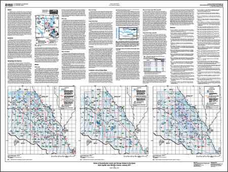
AbstractThe Equus Beds aquifer in southwestern Harvey County and northwestern Sedgwick County was developed to supply water to the city of Wichita and for irrigation in south-central Kansas. Water-level and storage-volume decreases that began with the development of the aquifer in the 1940s reached record to near-record lows in January 1993. Since 1993, the aquifer has been experiencing higher water levels and a partial recovery of storage volume. Potentiometric maps of the shallow and deep layers of the map show flow in both aquifer layers is generally from west to east. Water-level altitudes in the shallow aquifer layer ranged from a high of about 1,470 feet in the northwest corner of the study area to low of about 1,330 feet in the southeast corner of the study area; water-level altitudes in the deep aquifer layer ranged from a high of about 1,440 feet on the west edge of the study area to a low of about 1,330 feet in the southeast corner of the study area. In the northwest part of the study area, water-levels can be up to 50 feet higher in the shallow layer than in the deep layer of the Equus Beds aquifer. Measured water-level changes for August 1940 to January 2011 ranged from a decline of 16.52 feet to a rise of 2.22 feet. The change in storage volume from August 1940 to January 2011 was a decrease of about 104,000 acre-feet. This volume represents a recovery of about 151,000 acre-feet, or about 59 percent of the storage volume previously lost between August 1940 and January 1993. It also represents a recovery of about 63,000 acre-feet, or about 38 percent of the storage volume lost between August 1940 and January 2007. Major factors in these storage-volume recoveries are increased recharge from greater-than-normal precipitation and planned decreases in city pumpage that are part of Wichita's Integrated Local Water Supply Plan; however, part of the recovery may be because city and irrigation pumpage probably decreased in response to greater-than-normal precipitation in the study area. Storage volume from July 2010 to January 2011 did not increase as it commonly does from July to January. The change in storage volume from July 2010 to January 2011 was a decrease of 10,300 acre-feet, probably because average precipitation in the study area during August 2010 through January 2011 was about 3.01 inches less than the August through January normal of 12.63 inches for the study area. |
First posted December 28, 2011 For additional information contact: Part or all of this report is presented in Portable Document Format (PDF); the latest version of Adobe Reader or similar software is required to view it. Download the latest version of Adobe Reader, free of charge. |
Hansen, C.V., 2011, Status of groundwater levels and storage volume in the Equus Beds aquifer near Wichita, Kansas, January 2011: U.S. Geological Survey Scientific Investigations Map 3192, 1 sheet.

![]() U.S. Department of the Interior |
U.S. Geological Survey
U.S. Department of the Interior |
U.S. Geological Survey
URL: http://pubsdata.usgs.gov/pubs/sim/3192/index.html
Page Contact Information: GS Pubs Web Contact
Page Last Modified: Thursday, 01-Dec-2016 17:24:04 EST
