Skip Links

USGS - science for a changing world

Scientific Investigations Map 3193

Regional Potentiometric-Surface Map of the Great Basin Carbonate and Alluvial Aquifer System in Snake Valley and Surrounding Areas, Juab, Millard, and Beaver Counties, Utah, and White Pine and Lincoln Counties, Nevada

By Philip M. Gardner, Melissa D. Masbruch, Russell W. Plume, and Susan G. Buto

Thumbnail of and link to report PDF (5.6 MB) Abstract

Water-level measurements from 190 wells were used to develop a potentiometric-surface map of the east-central portion of the regional Great Basin carbonate and alluvial aquifer system in and around Snake Valley, eastern Nevada and western Utah. The map area covers approximately 9,000 square miles in Juab, Millard, and Beaver Counties, Utah, and White Pine and Lincoln Counties, Nevada. Recent (2007-2010) drilling by the Utah Geological Survey and U.S. Geological Survey has provided new data for areas where water-level measurements were previously unavailable. New water-level data were used to refine mapping of the pathways of intrabasin and interbasin groundwater flow. At 20 of these locations, nested observation wells provide vertical hydraulic gradient data and information related to the degree of connection between basin-fill aquifers and consolidated-rock aquifers. Multiple-year water-level hydrographs are also presented for 32 wells to illustrate the aquifer system’s response to interannual climate variations and well withdrawals.

First posted December 14, 2011


For additional information contact:
Director, Utah Water Science Center
U.S. Geological Survey
2329 Orton Circle
Salt Lake City, Utah 84119-2047
http://ut.usgs.gov/

Part or all of this report is presented in Portable Document Format (PDF); the latest version of Adobe Reader or similar software is required to view it. Download the latest version of Adobe Reader, free of charge.


Suggested citation:

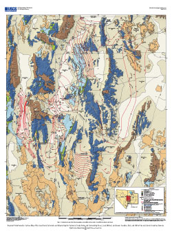
Gardner, P.M., Masbruch, M.D., Plume, R.W., and Buto, S.G., 2011, Regional potentiometric-surface map of the Great Basin carbonate and alluvial aquifer system in Snake Valley and surrounding areas, Juab, Millard, and Beaver Counties, Utah, and White Pine and Lincoln Counties, Nevada: U.S. Geological Survey Scientific Investigations Map 3193, 2 sheets.


Contents

Abstract

Introduction

Hydrogeology of the Groundwater Flow System

Data and Methods

Groundwater Flow in the Carbonate and Alluvial Aquifer System

Long-Term Water-Level Fluctuations

Summary

Acknowledgments

References Cited


Accessibility FOIA Privacy Policies and Notices

Take Pride in America logo USA.gov logo U.S. Department of the Interior | U.S. Geological Survey
URL: http://pubsdata.usgs.gov/pubs/sim/3193/index.html
Page Contact Information: GS Pubs Web Contact
Page Last Modified: Thursday, 01-Dec-2016 17:23:59 EST