Scientific Investigations Map 3200
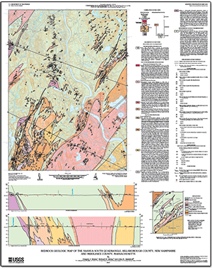
SummaryThe bedrock geology of the 7.5-minute Nashua South quadrangle consists primarily of deformed Silurian metasedimentary rocks of the Berwick Formation. The metasedimentary rocks are intruded by a Late Silurian to Early Devonian diorite-gabbro suite, Devonian rocks of the Ayer Granodiorite, Devonian granitic rocks of the New Hampshire Plutonic Suite including pegmatite and the Chelmsford Granite, and Jurassic diabase dikes. The bedrock geology was mapped to study the tectonic history of the area and to provide a framework for ongoing hydrogeologic characterization of the fractured bedrock of Massachusetts and New Hampshire. This report presents mapping by G.J. Walsh and R.H. Jahns and zircon U-Pb geochronology by J.N. Aleinikoff. The complete report consists of a map, text pamphlet, and GIS database. The map and text pamphlet are only available as downloadable files (see frame at right). The GIS database is available for download in ESRITM shapefile and Google EarthTM formats, and includes contacts of bedrock geologic units, faults, outcrops, structural geologic information, photographs, and a three-dimensional model. |
First posted January 20, 2013
For additional information contact: Part or all of this report is presented in Portable Document Format (PDF); the latest version of Adobe Reader or similar software is required to view it. Download the latest version of Adobe Reader, free of charge. |
Walsh, G.J., Jahns, R.H., and Aleinikoff, J.N., 2013, Bedrock geologic map of the Nashua South quadrangle, Hillsborough County, New Hampshire, and Middlesex County, Massachusetts: U.S. Geological Survey Scientific Investigations Map 3200, 1 sheet, scale 1:24,000, 31-p. pamphlet.

![]() U.S. Department of the Interior |
U.S. Geological Survey
U.S. Department of the Interior |
U.S. Geological Survey
URL: http://pubsdata.usgs.gov/pubs/sim/3200/index.html
Page Contact Information: GS Pubs Web Contact
Page Last Modified: Thursday, 01-Dec-2016 17:28:41 EST
