 Introduction
In 2007, the California Ocean Protection Council initiated the California Seafloor Mapping Program (CSMP), designed to create a comprehensive seafloor map of high-resolution bathymetry, marine benthic habitats, and geology within the 3-nautical-mile limit of California’s State Waters. The CSMP approach is to create highly detailed seafloor maps through collection, integration, interpretation, and visualization of swath sonar data, acoustic backscatter, seafloor video, seafloor photography, high-resolution seismic-reflection profiles, and bottom-sediment sampling data. The map products display seafloor morphology and character, identify potential marine benthic habitats, and illustrate both the surficial seafloor geology and shallow (to about 100 m) subsurface geology.
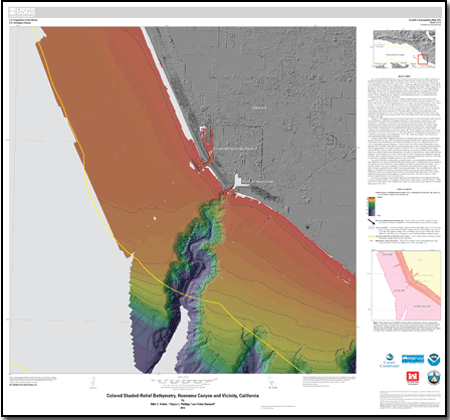
The Hueneme Canyon and vicinity map area lies within the eastern Santa Barbara Channel region of the Southern California Bight. The area is part of the Western Transverse Ranges geologic province, which is north of the California Continental Borderland. Significant clockwise rotation—at least 90°—since the early Miocene has been proposed for the Western Transverse Ranges, and the region is presently undergoing north-south shortening. This geologically complex region forms a major biogeographic transition zone, separating the cold-temperate Oregonian province north of Point Conception from the warm-temperate California province to the south. The map area, which is offshore of the Oxnard plain and west of and along the trend of the south flank of the Santa Monica Mountains, lies at the east end of the Santa Barbara littoral cell, characterized by west-to-east littoral transport of sediment derived mainly from coastal watersheds.
The Hueneme Canyon and vicinity map area in California’s State Waters is characterized by two major physiographic features: (1) the nearshore continental shelf, and (2) the Hueneme and Mugu Submarine Canyon system, which, in the map area, includes Hueneme Canyon and parts of three smaller, unnamed headless canyons incised into the shelf southeast of Hueneme Canyon. The shelf is underlain by tens of meters of interbedded upper Quaternary shelf, estuarine, and fluvial deposits that formed as sea level fluctuated in the last several hundred thousand years. Hueneme Canyon extends about 15 km offshore from its canyon head near the dredged navigation channel of the Port of Hueneme. The canyon is relatively deep (about 150 m at the California’s State Waters limit) and steep (canyon flanks as steep as 25° to 30°). Historically, Hueneme Canyon functioned as the eastern termination of the Santa Barbara littoral cell by trapping all eastward littoral drift, not only feeding the large Hueneme submarine fan but acting as the major conduit of sediment to the deep Santa Monica Basin; however, recent dredging programs needed to maintain Channel Islands Harbor and the Port of Hueneme have moved the nearshore sediment trapped by jetties and breakwaters to an area southeast of the Hueneme Canyon head.
Seafloor habitats in the broad Santa Barbara Channel region consist of significant amounts of soft sediment and isolated areas of rocky habitat that support kelp-forest communities nearshore and rocky-reef communities in deep water. The potential marine benthic habitat types mapped in the Hueneme Canyon and vicinity map area are related directly to the geomorphology and sedimentary processes that are the result of its Quaternary geologic history. The two basic megahabitats in the map area are Shelf (continental shelf) and Flank (continental slope).
The flat seafloor of the continental shelf in the Hueneme Canyon and vicinity map area is dynamic, as indicated by mobile sand sheets and coarser grained scour depressions. The active Hueneme Canyon provides considerable relief to the continental shelf in the map area, and its irregular morphology of eroded walls, landslide scarps, and deposits and gullies provide promising habitat for groundfish, crabs, shrimp, and other marine benthic organisms. Most invertebrates observed in the map area during camera ground-truth field operations are found on the edge of Hueneme Canyon, which may be an important area of recruitment and retention to other invertebrates and fishes. The smaller, more subtle, nonactive headless canyons located primarily on the continental slope also offer relief that provides habitat for groundfish and other organisms.
Chapters in the Pamphlet
Chapter 1. Introduction, by Samuel Y. Johnson and H. Gary Greene
Chapter 2. Bathymetry and Backscatter-Intensity Maps of Hueneme Canyon and Vicinity (Sheets 1, 2, and 3), by Peter Dartnell, Rikk G. Kvitek, and Andrew C. Ritchie
Chapter 3. Data Integration and Visualization for Hueneme Canyon and Vicinity (Sheet 4), by Peter Dartnell
Chapter 4. Seafloor-Character Map of Hueneme Canyon and Vicinity (Sheet 5), by Eleyne L. Phillips and Guy R. Cochrane
Chapter 5. Ground-Truth Studies for Hueneme Canyon and Vicinity (Sheet 6), by Nadine E. Golden and Guy R. Cochrane
Chapter 6. Potential Marine Benthic Habitat Map of Hueneme Canyon and Vicinity (Sheet 7), by H. Gary Greene and Charles A. Endris
Chapter 7. Subsurface Geology and Structure of Hueneme Canyon and Vicinity and the Santa Barbara Channel Region (Sheets 8 and 9), by Samuel Y. Johnson, Andrew C. Ritchie, Eleyne L. Phillips, Ray W. Sliter, Florence L. Wong, and William R. Normark
Chapter 8. Geologic and Geomorphic Map of Hueneme Canyon and Vicinity (Sheet 10) and Detailed Geology/Geomorphology, Slope, and Curvature Maps of Hueneme Canyon (Sheet 11), by Andrew C. Ritchie and Samuel Y. Johnson
Chapter 9. Predictive Distribution of Benthic Macro-Invertebrates for Hueneme Canyon and Vicinity Map Area and the Santa Barbara Channel Region (Sheet 12), by Lisa M. Krigsman, Mary M. Yoklavich, Nadine E. Golden, and Guy R. Cochrane
Also of Interest
Scientific Investigations Map 3254, California State Waters Map Series—Offshore of Ventura, California, by Samuel Y. Johnson and others.
Scientific Investigations Map 3281, California State Waters Map Series—Offshore of Santa Barbara, California, by Samuel Y. Johnson and others.
Scientific Investigations Map 3261, California State Waters Map Series—Offshore of Carpinteria, California, by Samuel Y. Johnson and others.
Scientific Investigations Map 3302, California State Waters Map Series—Offshore of Coal Oil Point, California, by Samuel Y. Johnson and others.
Scientific Investigations Map 3319, California State Waters Map Series—Offshore of Refugio Beach, California by Samuel Y. Johnson and others.

