Scientific Investigations Map 3229
|
First posted September 5, 2012 For additional information contact: Part or all of this report is presented in Portable Document Format (PDF); the latest version of Adobe Reader or similar software is required to view it. Download the latest version of Adobe Reader, free of charge. |
Wood, M.S., Skinner, K.D., and Fosness, R.L., 2012, Bathymetry and capacity of Blackfoot Reservoir, Caribou County, Idaho, 2011: U.S. Geological Survey Scientific Investigations Map 3229, 1 sheet.
Abstract
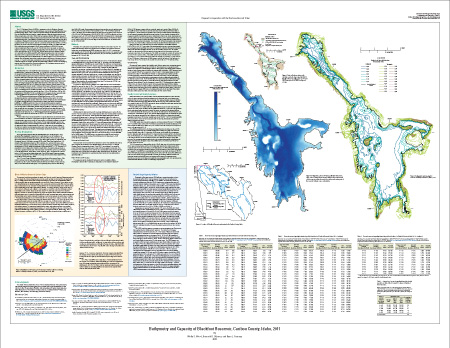
Introduction
Previous Investigations
Methods
Quality Control and Quality Assurance
Effect of Wind on Reservoir Surface Slope
Revised Stage-Capacity Relation
Acknowledgments
References Cited

![]() U.S. Department of the Interior |
U.S. Geological Survey
U.S. Department of the Interior |
U.S. Geological Survey
URL: http://pubsdata.usgs.gov/pubs/sim/3229/index.html
Page Contact Information: GS Pubs Web Contact
Page Last Modified: Thursday, 01-Dec-2016 17:27:19 EST