Scientific Investigations Map 3248
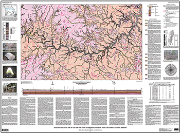
AbstractThe Jam Up Cave and Pine Crest 7.5-minute quadrangles are located in south-central Missouri within the Salem Plateau region of the Ozark Plateaus physiographic province. About 2,400 to 3,100 feet (ft) of flat-lying to gently dipping Lower Paleozoic sedimentary rocks, mostly dolomite, chert, sandstone, and orthoquartzite, overlie Mesoproterozoic igneous basement rocks. Unconsolidated residuum, colluvium, terrace deposits, and alluvium overlie the sedimentary rocks. Numerous karst features, such as sinkholes, caves, and springs, have formed in the carbonate rocks. Many streams are spring fed. The topography is a dissected karst plain with elevations ranging from about 690 ft where the Jacks Fork River exits the northeastern corner of the Jam Up Cave quadrangle to about 1,350 ft in upland areas along the north-central edge and southwestern corner of the Pine Crest quadrangle. The most prominent physiographic feature is the valley of the Jacks Fork River. This reach of the upper Jacks Fork, with its clean, swiftly-flowing water confined by low cliffs and bluffs, provides one of the most beautiful canoe float trips in the nation. Most of the land in the quadrangles is privately owned and used primarily for grazing cattle and horses and growing timber. A large minority of the land within the quadrangles is publicly owned by the Ozark National Scenic Riverways of the National Park Service. Geologic mapping for this investigation was conducted in 2005 and 2006. |
First posted July 8, 2013
For additional information contact: Or David J. Weary Part or all of this report is presented in Portable Document Format (PDF); the latest version of Adobe Reader or similar software is required to view it. Download the latest version of Adobe Reader, free of charge. |
Weary, D.J., Orndorff, R.C., and Repetski, J.E., 2013, Geologic map of the Jam Up Cave and Pine Crest quadrangles, Shannon, Texas, and Howell Counties, Missouri: U.S. Geological Survey Scientific Investigations Map 3248, 1 sheet, scale 1:24,000; also available at https://pubs.usgs.gov/sim/3248/.

![]() U.S. Department of the Interior |
U.S. Geological Survey
U.S. Department of the Interior |
U.S. Geological Survey
URL: http://pubsdata.usgs.gov/pubs/sim/3248/index.html
Page Contact Information: GS Pubs Web Contact
Page Last Modified: Thursday, 01-Dec-2016 17:30:38 EST
