 Introduction
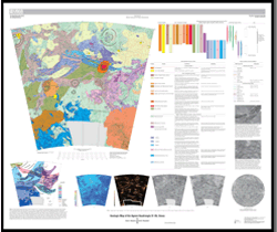
The Agnesi quadrangle (V–45), named for centrally located Agnesi crater, encompasses approximately 6,500,000 km2 extending from lat 25° to 50° S. and from long 30° to 60° E. The V–45 quadrangle lies within Venus’ lowland broadly between highlands Ovda Regio to the northeast and Alpha Regio to the west. The region ranges in altitude from 6,051 to 6,054 km, with an average of ~6,052 km, which is essentially mean planetary radius. The quadrangle displays a wide range of features including large to small arcuate exposures of ribbon-tessera terrain (Hansen and Willis, 1998), ten lowland coronae, two montes, 13 pristine impact craters, and long but localized volcanic flows sourced to the west in V–44. Shield terrain (Hansen, 2005) occurs across much of the V–45 quadrangle. Although V–45 lies topographically within the lowland, it includes only one planitia (Fonueha Planitia), perhaps because the features mentioned decorate it.
Geologic mapping of the Agnesi quadrangle (V–45) provides an opportunity (1) to examine the nature of lowland ribbon-tessera terrain, as compared to highland ribbon-tessera terrain; (2) to examine the nature and history of lowland coronae and montes to evaluate hypotheses for the evolution of these features; and (3) to evaluate global catastrophic/episodic resurfacing hypotheses.
Ribbon-tessera terrain (Hansen and Willis, 1998), a structurally distinctive terrain marked by roughly orthogonal fold axes and ribbon troughs, characterizes Venusian crustal plateaus (Hansen and others, 1999), although this distinctive fabric is also variably preserved across some lowland regions (Hansen and Willis, 1996, 1998), including the Agnesi quadrangle. Isolated kipukas of ribbon-tessera terrain protrude through the shield-terrain veneer and preserve evidence of local surface processes that predated shield-terrain emplacement, including those leading to regional development of tessera terrain fabrics. The ribbon-tessera fabrics are similar to the fabrics that characterize high-standing crustal plateaus, such as nearby Ovda and Alpha Regiones. Ribbon-bearing kipukas may preserve evidence of ancient collapsed crustal plateaus (Phillips and Hansen, 1994; Ivanov and Head, 1996; Hansen and Willis, 1998; Ghent and Tibuleac, 2002), or they may record different, but rheologically similar, processes.
Geologic mapping of the V–45 quadrangle constrains the geologic history of 12 lowland coronae and montes. Lowland coronae are relatively rare (10% of coronae); they do not form chains, typical of mesoland coronae (Phillips and Hansen, 1994), nor do they cluster, typical of highland coronae associated with volcanic rises (Stofan and others, 2001). The evolution of all coronae, whether by a single mechanism or a range of mechanisms, is a topic of debate (for example, Stofan and others, 1992, 2001; Vita-Finzi and others, 2005; Hamilton, 2005). The V–45 quadrangle hosts about 20 percent of the lowland coronae on Venus; the geologic history of these features should provide critical insight toward understanding coronae evolution.
Two general classes of hypotheses have emerged to address the near random spatial distribution of ~970 apparently pristine impact craters across the surface of Venus: (1) catastrophic/episodic resurfacing and (2) equilibrium/evolutionary resurfacing. Catastrophic/episodic hypotheses propose that a global-scale, temporally punctuated event or events dominated Venus’ evolution and that the generally uniform impact crater distribution (Schaber and others, 1992; Phillips and others, 1992; Herrick and others, 1997) reflects craters that accumulated during relative global quiescence since that event (for example, Strom and others, 1994; Herrick, 1994; Turcotte and others, 1999). Equilibrium/evolutionary hypotheses suggest instead that the near random crater distribution results from relatively continuous, but spatially localized, resurfacing in which volcanic and (or) tectonic processes occur across the planet through time, although the style of operative processes may have varied temporally and spatially (for example, Phillips and others, 1992; Guest and Stofan, 1999; Hansen and Young, 2007). Geologic relations within the map area allow us to test the catastrophic/episodic versus equilibrium/evolutionary resurfacing hypotheses.

