 Summary Summary
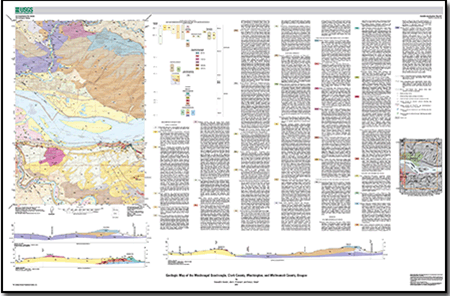
The Washougal 7.5’ quadrangle spans the boundary between the Portland Basin and the Columbia River Gorge, approximately 30 km east of Portland, Oregon. The map area contains the westernmost portion of the Columbia River Gorge National Scenic area as well as the rapidly growing areas surrounding the Clark County, Washington, cities of Camas and Washougal. The Columbia River transects the map area, and two major tributaries, the Washougal River in Washington and the Sandy River in Oregon, also flow through the quadrangle. The Columbia, Washougal, and Sandy Rivers have all cut deep valleys through hilly uplands, exposing Oligocene volcanic bedrock in the north part of the map area and lava flows of the Miocene Columbia River Basalt Group in the western Columbia River Gorge. Elsewhere in the map area, these older rocks are buried beneath weakly consolidated to well-consolidated Neogene and younger basin-fill sedimentary rocks and Quaternary volcanic and sedimentary deposits.
The Portland Basin is part of the Coastal Lowland that separates the Cascade Range from the Oregon Coast Range. The basin has been interpreted as a pull-apart basin located in the releasing stepover between two en echelon, northwest-striking, right-lateral fault zones. These fault zones are thought to reflect regional transpression, transtension, and dextral shear within the forearc in response to oblique subduction of the Pacific plate along the Cascadia Subduction Zone. The southwestern margin of the Portland Basin is a well-defined topographic break along the base of the Tualatin Mountains, an asymmetric anticlinal ridge that is bounded on its northeast flank by the Portland Hills Fault Zone, which is probably an active structure. The nature of the corresponding northeastern margin of the basin is less clear, but a series of poorly defined and partially buried dextral extensional structures has been hypothesized from topography, microseismicity, potential-field anomalies, and reconnaissance geologic mapping.
This map is a contribution to a program designed to improve the geologic database for the Portland Basin region of the Pacific Northwest urban corridor, the densely populated Cascadia forearc region of western Washington and Oregon. Updated, more detailed information on the bedrock and surficial geology of the basin and its surrounding area will facilitate improved assessments of seismic risk, and resource availability in this rapidly growing region.
|
First posted September 30, 2013
Files for viewing and printing:
Data:
Part of this report is presented in Portable Document Format (PDF); the latest version of Adobe Reader or similar software is required to view it. Download the latest version of Adobe Reader, free of charge. |

