Scientific Investigations Map 3265
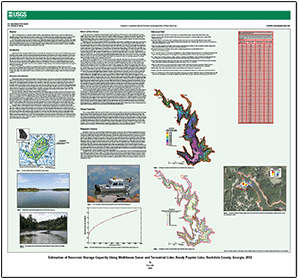
AbstractThe U.S. Geological Survey, in cooperation with the Rockdale County Department of Water Resources, conducted a bathymetric and topographic survey of Randy Poynter Lake in northern Georgia in 2012. The Randy Poynter Lake watershed drains surface area from Rockdale, Gwinnett, and Walton Counties. The reservoir serves as the water supply for the Conyers-Rockdale Big Haynes Impoundment Authority. The Randy Poynter reservoir was surveyed to prepare a current bathymetric map and determine storage capacities at specified water-surface elevations. Topographic and bathymetric data were collected using a marine-based mobile mapping unit to estimate storage capacity. The marine-based mobile mapping unit operates with several components: multibeam echosounder, singlebeam echosounder, light detection and ranging system, navigation and motion-sensing system, and data acquisition computer. All data were processed and combined to develop a triangulated irregular network, a reservoir capacity table, and a bathymetric contour map. |
First posted August 8, 2013
For additional information contact: Part or all of this report is presented in Portable Document Format (PDF); the latest version of Adobe Reader or similar software is required to view it. Download the latest version of Adobe Reader, free of charge. |
Lee, K.G., 2013, Estimation of reservoir storage capacity using multibeam sonar and terrestrial lidar, Randy Poynter Lake, Rockdale County, Georgia, 2012: U.S. Geological Survey Scientific Investigations Map 3265, 1 sheet, https://pubs.usgs.gov/sim/3265/.
Abstract
Introduction
Description of the Study Area
Methods and Data Collection
Storage Capacities
Bathymetric Contours
References Cited

![]() U.S. Department of the Interior |
U.S. Geological Survey
U.S. Department of the Interior |
U.S. Geological Survey
URL: http://pubsdata.usgs.gov/pubs/sim/3265/index.html
Page Contact Information: GS Pubs Web Contact
Page Last Modified: Thursday, 01-Dec-2016 17:30:50 EST
