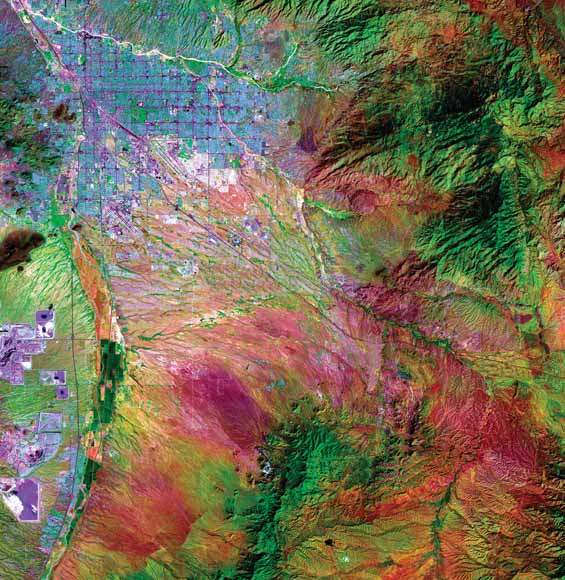
Landsat satellite image of the Tucson Basin. See figure 2 (page 6) for explanation. |
A detailed stratigraphy is presented, based on well cuttings and geophysical logs, for the 3,658 m of Upper Jurassic through upper Tertiary sedimentary and volcanic rocks overlying Precambrian(?) granitoid basement in the Tucson Basin. This is a revision of previous interpretations of Tucson Basin stratigraphy and is based in part on four new 40Ar/39Ar dates. The stratigraphic units are interpreted in terms of depositional environments and tectonic setting. The Tucson Basin is a relatively large late Cenozoic extensional basin developed in the upper plate of the Catalina detachment fault in the southern Basin and Range Province, southeastern Arizona. In 1972, Exxon Company, U.S.A., drilled an exploration well (Exxon State (32)-1) near the center of the Tucson Basin that penetrated 3,658 m (12,001 ft) of sedimentary and volcanic rocks above granitoid basement. Detailed study of cuttings and geophysical logs of the Exxon State well has led to revision of the previously reported subsurface stratigraphy for the basin and provided new insight into its depositional and tectonic history. There is evidence that detachment faulting and uplift of the adjacent Catalina core complex on the north have affected the subsurface geometry of the basin. The gravity anomaly map of the Tucson Basin indicates that the locations of subbasins along the north-trending axis of the main basin coincide with the intersection of this axis with west-southwest projections of synforms in the adjacent core complex. In other words, the subbasins overlie synforms and the ridges between subbasins overlie antiforms. The Exxon State well was drilled near the center of one of the subbasins.The Exxon well was drilled to a total |
Download Scientific Investigations Report 5076 as a 42-page PDF file (sir2004-5076.pdf; 26.5 MB)
For questions about the content of this report, contact Brenda Houser
Download a current version of Acrobat Reader for free
| Help
| PDF help
| Western reports main page | Western Scientific Investigations Reports |
| Privacy
Statement | Disclaimer
| Accessibility |
| Geologic
Division | Western Mineral Resources Program
|
This report is only available online.