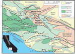
Mount Pinos and Frazier Mountain are two prominent mountains just south of the
San Andreas fault in the western Transverse Ranges of southern California,
a region that has undergone rapid Quaternary contraction and uplift.
Both mountains are underlain, at least in part, by thrusts that place
granitic and gneissic rocks over sedimentary rocks as young as Pliocene.
Broad profiles and nearly flat summits of each mountain have previously
been interpreted as relicts of a raised erosion surface. However, several
features bring this interpretation into question. First, lag or stream
gravels do not mantle the summit surfaces. Second, extensive landslide
deposits, mostly pre-Holocene and deeply incised, mantle the flanks of
both mountains. Third, a pervasive fracture and crushed-rock network
pervades the crystalline rocks underlying both mountains. The orientation
of the fractures, prominent in roadcuts on Mount Pinos, is essentially random. “Hill-and-saddle” morphology characterizes ridges radiating from the summits, especially on Mount
Pinos; outcrops are sparse on the hills and are nonexistent in the saddles,
suggesting fractures are concentrated in the saddles. Latest movement
on the thrusts underlying the two mountain massifs is probably early
Quaternary, during which the mountains were uplifted to considerably
higher (although unknown) elevations than at present. A model proposes
that during thrusting, ground accelerations in the hanging wall, particularly
near thrust tips, were high enough to pervasively fracture the hanging-wall
rocks, thereby weakening them and producing essentially an assemblage
of loose blocks. Movement over flexures in the fault surface accentuated
fracturing. The lowered shear stresses necessary for failure, coupled
with deep dissection and ongoing seismic activity, reduced gravitational
potential by spreading the mountain massifs, triggering flanking landslides and producing broad, flat-topped mountains. This study
developed from mapping in the western Transverse Ranges as part of the
U.S. Geological Survey’s Southern California Areal Mapping Project (SCAMP).
Version 1.0
|
| Posted April 2004 |
|
Part or all of this report is presented in Portable Document Format. The latest
version of Adobe Acrobat Reader or similar software is required
to view it. If you wish to download the latest version of Acrobat
Reader free of charge, click here.
|
|
