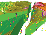
This report includes a digital, three-dimensional (3-D) faulted hydrostratigraphic
model we have constructed to represent the geologic framework of the
Edwards aquifer system in the area of San Antonio, northern Bexar County,
Texas. The model is based on mapped geologic relationships that reflect
the complex structures of the Balcones fault zone, detailed lithologic
descriptions and interpretations of about 40 principal wells (and qualified
data from numerous other wells), and a conceptual model of the gross
geometry of the Edwards Group units derived from prior interpretations
of depositional environments and paleogeography.
The EarthVision 3-D software included in this publication is provided for use
on four platforms: Windows 2000/XP, SGI, SUN, and Linux. Please see the
Readme1.txt file for information about starting and using the software
on each platform. The 3-D model and viewer software can be downloaded
from this Web site, and they are also available on the CD-ROM version
of this report, which is available as a sales item from Information Services,
U.S. Geological Survey (1-888-ASK-USGS).
Earth Vision software is the intellectual property of Dynamic Graphics, Inc.,
and is used here with their permission. Other than those rights granted
to the USGS and third parties to assist them in using this product (any
venue), Dynamic Graphics, Inc., reserves all rights in their software.
Any appearances of trade, product, or firm names, or private logos, in
or on this product do not, and are not intended to, imply endorsement
by the U.S. Government.
Version 1.0
|
| Posted April 2004 |
|
Part or all of this report is presented in Portable Document Format. The latest
version of Adobe Acrobat Reader or similar software is required
to view it. If you wish to download the latest version of Acrobat
Reader free of charge, click here.
|
|
