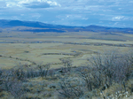
An S-wave refraction survey was conducted in the Yampa River valley near Steamboat
Springs, Colo., to determine how well this method could map alluvium,
a major source of construction aggregate. At the field site, about 1
m of soil overlaid 8 m of alluvium that, in turn, overlaid sedimentary
bedrock. The traveltimes of the direct and refracted S-waves were used
to construct velocity cross sections whose various regions were directly
related to the soil, alluvium, and bedrock. The cross sections were constrained
to match geologic logs that were developed from drill-hole data. This
constraint minimized the ambiguity in estimates of the thickness and
the velocity of the alluvium, an ambiguity that is inherent to the S-wave
refraction method. In the cross sections, the estimated S-wave velocity
of the alluvium changed in the horizontal direction, and these changes
were attributed to changes in composition of the alluvium. The estimated S-wave velocity of the alluvium was practically constant in
the vertical direction, indicating that the fine layering observed in
the geologic logs could not be detected. The S-wave refraction survey,
in conjunction with independent information such as geologic logs, was
found to be suitable for mapping the thickness of the alluvium.
Version 1.0
|
| Posted June 2005 |
|
Part or all of this report is presented in Portable Document Format. The latest
version of Adobe Acrobat Reader or similar software is required
to view it. If you wish to download the latest version of Acrobat
Reader free of charge, click here.
|
|
