U.S. Geological Survey Scientific Investigations Report 2005-5065
Back to the Table of Contents
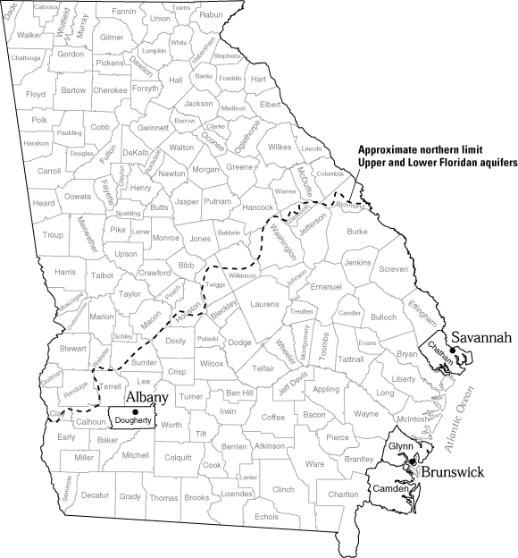
The quality of ground water from the Upper and Lower Floridan aquifers is monitored in the Albany and coastal areas. In the south-central part of Dougherty County near Albany, wells are monitored annually for nitrate concentration. In coastal Georgia, chloride concentration in water from the Upper and Lower Floridan aquifers has been monitored since the 1950s in the Savannah and Brunswick areas and since the early 1990s in the Camden County area.
The Upper Floridan aquifer is shallow in southwest Georgia where agricultural land use is prevalent, making the ground water susceptible to contamination from nitrates and other chemicals. Monitoring may serve as an early-warning sign of potential contamination of water supplies. Nitrate levels greater than 10 milligrams per liter (mg/L) (the maximum contaminant level for nitrate set by the U.S. Environmental Protection Agency, 2000) have been detected in the area.
Samples were collected from 12 wells during November 2002, from 4 wells and one stream during May 2003, and from 14 wells and one stream during November 2003 southwest of Albany, and analyzed for nitrate concentrations. Nitrate concentrations increased in 8 of the 14 ground-water samples from November of 2002 to November 2003 (table, below). By November 2003, one sample had a concentration greater than 10 mg/L, seven samples had concentrations ranging between 3 and 10 mg/L, and seven samples had concen- trations less than 3 mg/L (map, facing page).
Samples collected during November 2002 and November 2003 were plotted on a trilinear diagram. Both of these diagrams (bottom of facing page) show that the surface-water sample has a different chemical composition than the ground-water samples. The surface-water sample has a higher sodium, potassium, and magnesium content and a lower carbonate and bicarbonate content than do the ground-water samples.
U.S. Environmental Protection Agency, 2000, Maximum contaminant levels (Part 143, National Secondary Drinking Water Regulations): U.S. Code of Federal Regulations, Title 40, Parts 100 –149, revised as of July 1, 2000, p. 612– 614.
| Site name | September 1998 NO3-N, in mg/L | April 1999 NO3-N, in mg/L | April 2001 NO2 + NO3 as N, in mg/L | November 2001 Dissolved NO2 + NO3 as N, in mg/L | November 2002 NO3-N, in mg/L | May 2003 NO3-N, in mg/L | November 2003 NO3-N, in mg/L |
|---|---|---|---|---|---|---|---|
| 12K053 | — | — | — | — | 2.0 | — | 2.2 |
| 12K101 | 1.8 | 1.9 | — | 2.2 | 2.1 | — | 2.1 |
| 12K129 | — | — | — | 3.1 | 2.9 | — | 2.9 |
| 12K175 | 3.8 | 5.7 | 5.0 | 5.9 | 5.4 | — | 6.1 |
| 12K180 | — | — | — | — | 1.56 | 1.7 | 1.4 |
| 12L061 | 11 | 12 | 12 | 12 | 12.5 | — | 13.4 |
| 12L277 | 7.5 | 6.9 | 6.5 | 8.0 | 6.3 | 9.0 | 8.2 |
| 12L339 | 5.9 | 5.4 | — | 5.0 | — | — | — |
| 12L344 | 6.0 | 5.1 | 2.7 | 1.6 | 1.7 | — | 1.9 |
| 12L346 | — | — | — | — | — | — | 7.2 |
| 12L348 | — | 6.5 | 6.4 | 7.1 | 6.8 | — | 6.9 |
| 12L350 | 3.0 | 2.9 | — | 4.8 | 5.5 | — | 2.6 |
| 12L357 | 5.9 | 3.1 | — | 2.0 | — | — | — |
| 12L370 | — | — | — | — | — | — | 7.1 |
| 12L373 | — | — | — | 7.2 | 6.6 | 8.6 | 7.5 |
| 12L376 | — | — | — | — | 6.5 | 8.8 | 8.3 |
| 02352560 | — | — | — | — | — | 0.4 | 0.45 |
NO3-N, nitrate as nitrogen; NO2 + NO3 as N, nitrite plus nitrate as nitrogen; mg/L, milligrams per liter; —, no data
![]() Map of Dougherty County and nitrate concentrations in wells, Novermber 2003
Map of Dougherty County and nitrate concentrations in wells, Novermber 2003
![]() Trilinear diagrams for samples collected during November 2002 and November 2003
Trilinear diagrams for samples collected during November 2002 and November 2003
Procedures for monitoring chloride concentration in the city of Savannah area were modified during 2003 to account for considerable variation in measured concentrations, largely because of partial mixing of water within the interval of the well open to the Upper or Lower Floridan aquifer. Stratification of fresh-water and relatively denser saline water within the open interval result in variations in water chemistry with depth — water having higher chloride concentrations has a higher density than fresher water, resulting in stratification within the open interval.
To provide a more accurate representation of chloride concentrations, a new procedure for monitoring chloride concentration was implemented during December 2003, with focus on three areas — Tybee Island, Fort Pulaski, and Skidaway Island (map, below). These areas represent the most seaward locations in the Savannah area and likely the first locations to be affected by saltwater migrating laterally from the sea. Historical data from these areas indicate that chloride concentration generally increases with depth below land surface.

The new procedure involves collection of borehole geophysical logs and grab water samples from open intervals in wells completed in the Upper or Lower Floridan aquifer (table, facing page). Borehole geophysical logs include fluid resistivity, which is an indicator of dissolved-solids concentration; and fluid temperature and caliper, which are indicators of possible breaches in the well casing that might compromise the reliability of water-quality measurements. The inverse of fluid resistivity is fluid conductivity, which is reported herein in units of specific conductance, microsiemens per centi-meter (µS/cm) — higher values reflect higher concentrations of dissolved solids, which are mostly comprised of dissolved chloride in the Savannah area. Grab samples were collected at discrete intervals reflecting the range of specific conductance observed in the well during logging. Analysis of grab samples is summarized in a table and shown together with geophysical logs on the facing page.
At Tybee Island, fluid conductivity (resistivity) logs (facing page) were collected from well 39Q024, completed in the Lower Floridan aquifer, on March 25, 1996, and on December 9, 2003. Grab samples also were collected on December 9, 2003 — chloride concentration ranged from 2,734 milligrams per liter (mg/L) at a depth of 845 ft to 2,758 mg/L at a depth of 860 ft. Previous composite samples from the entire open interval (840 – 880 ft) during 1994 – 2001 ranged from about 2,700 to 3,400 mg/L. Between 1996 and 2003, fluid conductivity in the open interval of well 39Q024 generally decreased, reflecting a decrease in dissolved solids concentration from an average of 11,780 µS/cm during March 1996 to 10,690 µS/cm during December 2003.
At Skidaway Island, fluid conductivity (resistivity) logs and grab samples were collected on January 6, 2000, and December 10, 2003, from well 37P113, completed in the Lower Floridan aquifer (facing page). Chloride concentrations of grab samples collected from common intervals in well 37P113 decreased during 2000 – 03. During 2000, concentrations in samples collected at depths of 900 and 1,085 ft were 996 and 4,140 mg/L, respectively; whereas during 2003, concentrations in samples collected at depths of 900 and 1,070 ft were 248 and 3,076 mg/L, respectively. Chloride concentrations in previous composite samples from the entire open interval (700 –1,100 ft) during 1985 – 2001 ranged from about 300 to 1,000 mg/L. Between 2000 and 2003, fluid conductivity in the open interval of well 37P113 generally decreased, reflecting a decrease in dissolved-solids concentration from an average of 4,910 µS/cm during January 2000 to 4,150 µS/cm during December 2003.
Fluid conductivity (resistivity) logs and grab samples were also collected on December 10, 2003, from well 37P114, completed in the Upper Floridan aquifer at Skidaway Island. Water in the Upper Floridan is fresh at this site, with dissolved chloride concentrations of 6.7 mg/L at 300 ft and 5.4 mg/L at 360 ft. Average fluid conductivity in the open interval of this well was 227 µS/cm.
At Fort Pulaski, fluid conductivity (resistivity) logs and grab samples were collected on January 4, 2000, and December 8, 2003, from well 38Q002, completed in the Upper Floridan aquifer (facing page). Unfortunately, the fluid resistivity probe malfunctioned during the December 2003 effort, so a log for this period is not available. Average fluid conductivity during January 2000 in the open interval of the well (110 – 348 ft) was 243 µS/cm. Chloride concentration of grab samples collected from similar intervals in well 38Q002 showed little change during 2000 – 03. During December 2003, concentrations in samples collected at depths of 200 and 320 ft were 12.8 and 9.6 mg/L, respectively.
| Site name | Other identifier | Open interval (feet below land surface) | Water-bearing unit1 | Grab sample depth (feet below land surface | Chloride concentration (mg/L) | Grab sample depth (feet below land surface | Chloride concentration (mg/L) |
|---|---|---|---|---|---|---|---|
| January 2000 | December 2003 | ||||||
| 39Q024 | Georgia Geologic Survey, Tybee Island, test well 1 | 840 – 880 | L | — | — | 860 | 2,758 |
| — | — | 845 | 2,734 | ||||
| 37P113 | Skidaway Institute test well 1 | 700 – 1,100 | L | 710 | 156.5 | 900 | 248 |
| 750 | 535 | 1,070 | 3,076 | ||||
| 800 | 1,012 | — | — | ||||
| 900 | 996 | — | — | ||||
| 1,085 | 4,140 | ||||||
| 37P114 | Skidaway Institute test well 2 | 262 – 400 | U | — | — | 300 | 6.7 |
| — | — | 360 | 5.4 | ||||
| 38Q002 | U.S. National Park Service, Fort Pulaski Pilot House | 110 – 348 | U | 115 | 14.96 | 200 | 12.8 |
| 145 | 34.9 | 320 | 9.6 | ||||
| 180 | 25.85 | ||||||
| 215 | 10.35 | ||||||
| 250 | 30 | ||||||
| 285 | 9.06 | ||||||
| 320 | 9.28 | ||||||
1L, Lower Floridan aquifer; U, Upper Floridan aquifer; mg/L, milligrams per liter
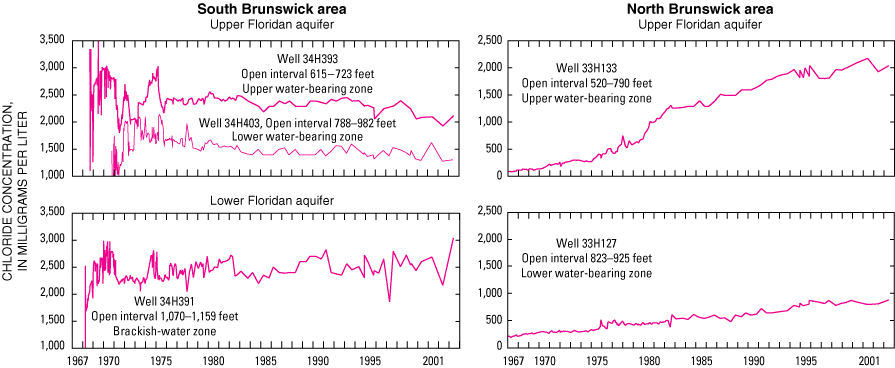
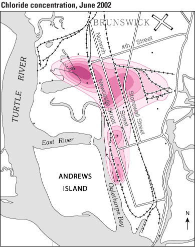
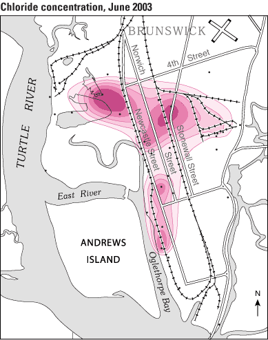
Water supply in the Brunswick area primarily is obtained from wells completed in the Upper Floridan aquifer. Intense pumping has reduced pressure in the aquifer and resulted in salt- water intrusion locally at Brunswick. Saltwater was first detected in the southernmost part of Brunswick during the late 1950s (Wait, 1965). Saltwater was migrating upward from deep saline zones through breaches in confining units as a result of reduced pressure in the aquifer. By the 1960s, a plume had migrated northward toward two major industrial pumping centers. Currently (June 2003), chloride concentration in water from the Upper Floridan aquifer is above State and Federal secondary drinking-water standards (Georgia Environmental Protection Division, 1997; U.S. Environmental Protection Agency, 2000) in a 2-square-mile area, and exceeds 2,250 milligrams per liter (mg/L) in part of the area.
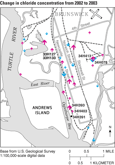
Chloride concentrations have been monitored in the Brunswick area since the late 1950s. Graphs of chloride concen- tration in water samples from wells in the upper and lower water-bearing zones of the Upper Floridan aquifer are shown for wells in the south Brunswick area (graphs for wells 34H393 and 34H403, below) and north Brunswick area (graphs for wells 33H127 and 33H133, below). Chloride concentration in water from the Lower Floridan aquifer is shown for well 34H391 in the south Brunswick area (graph, below). More information on the Brunswick area monitoring can be accessed at http://ga2.er.usgs.gov/Brunswick
Maps showing the concentration of dissolved chloride in the Upper Floridan aquifer at Brunswick were prepared for June 2002 and June 2003 (facing page). The June 2002 map (43 wells) is similar to the previously published map for 2001 (Leeth and others, 2003) and shows that areas of highest concentration are near the two industrial pumping centers in the northern part of the city, as well as the original area of contamination in the southern part of the city. The map for June 2003 (56 wells) shows the effect of reduced pumping from the Upper Floridan aquifer at an industrial wellfield located along the northeastern extent of the plume. This decrease in pumping changed flow patterns in the aquifer and the distribution of dissolved chloride. In the southern plume area, concentrations increased by as much as 237 mg/L. Directly north, in the central plume area, concentrations decreased by as much as 92 mg/L. In the north-central and western plume area, concentrations increased by as much as 421 mg/L. In parts of the area, concentrations in wells located adjacent to each other varied substantially— for example, in the northeastern plume area, concentrations in well 34H078 dropped by 107 mg/L, whereas concentrations in well 34H413, located about 700 ft northeast of the well increased by 202 mg/L. The reason for this variation is unknown; however, previous investigators have reported the presence of fractures and solution openings in the Brunswick area that could produce highly variable flow conditions in the area (Maslia and Prowell, 1990; Jones and others, 2002).
Georgia Environmental Protection Division, 1997, Secondary maximum contaminant levels for drinking water: Environmental Rule 391-3-5-19, revised October 1997: Official Code of Georgia Annotated Statutes, Statute 12-5-170 (Georgia Safe Drinking Water Act), variously paginated.
Jones, L.E., Prowell, D.C., and Maslia, M.L., 2002, Hydrogeology and water quality (1978) of the Floridan aquifer system at U.S. Geological Survey TW-26, on Colonels Island, near Brunswick, Georgia: U.S. Geo-logical Survey Water-Resources Investigations Report 02-4020, 44 p.
Leeth, D.C., Clarke, J.S., Craigg, S.D., and Wipperfurth, C.J., 2003, Ground-water conditions in Georgia, 2001: U.S. Geological Survey Water-Resources Investigations Report 03-4032, 96 p. Online at http://ga.water.usgs.gov/pubs/wrir/wrir034032/
Maslia, M.L., and Prowell, D.C., 1990, Effect of faults on fluid flow and chloride contamination in a carbonate aquifer system: Journal of hydrology, vol. 115, p. 1– 49.
U.S. Environmental Protection Agency, 2000, Maximum contaminant levels (Part 143, National Secondary Drinking Water Regulations): U.S. Code of Federal Regulations, Title 40, Parts 100 –149, revised as of July 1, 2000, p. 612 – 614.
Wait, R.L., 1965, Geology and occurrence of fresh and brackish ground water in Glynn County, Georgia: U.S. Geological Survey Water-Supply Paper 1613-E, 94 p.
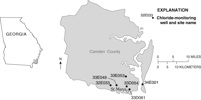
Chloride concentrations in the Upper Floridan aquifer have been monitored periodically in the Camden County area from 1959 to 1997 and annually from 1994 to the present. During 2002 – 03, the U.S. Geological Survey collected 82 water samples from 35 wells. Six of the wells (table below) are part of a network maintained for the St. Johns Water Management District in Florida. The other 29 wells were sampled as part of a study evaluating the effects of decreased ground-water withdrawal in the Camden County, St. Marys area because of the closure of the Durango Paper Mill during October 2002. Data from these wells indicate chloride concentrations generally ranged from 30 to 50 milligrams per liter (mg/L), with the exception of well 33D061, which had concentrations ranging from 48 to 184 mg/L during 1982 – 2003. The source of the high chloride concentration in this well is not known; how-ever, Rose (2001, 2002) evaluated the potential for saltwater intrusion in Camden County. In addition in adjacent Glynn County, several investigators (Wait, 1965; Gregg and Zimmerman, 1974; Krause and Randolph, 1989; Clarke and others, 1990; Jones and others, 2002) have documented chloride contamination of the Upper Floridan aquifer from deep saline zones.
Clarke, J.S., Hacke, C.M., and Peck, M.F., 1990, Geology and ground-water resources of the coastal area of Georgia: Georgia Geologic Survey Information Circular 113, 106 p.
Gregg, D.O., and Zimmerman, E.A., 1974, Geologic and hydrologic control of chloride contamination in aquifers at Brunswick, Glynn County, Georgia: U.S. Geological Water-Supply Paper 2029-D, 44 p.
Jones, L.E., Prowell, D.C., and Maslia, M.L., 2002, Hydrogeology and water quality (1978) of the Floridan aquifer system at U.S. Geological Survey TW-26, on Colonels Island, near Brunswick, Georgia: U.S. Geological Survey Water-Resources Investigations Report 02-4020, 44 p.
Krause, R.E., and Randolph, R.B., 1989, Hydrology of the Floridan aquifer system in southeast Georgia and adjacent parts of Florida and South Carolina: U.S. Geological Survey Professional Paper 1403-D, 65 p.
Rose, Seth, 2001, Susceptibility of the Upper Floridan aquifer in Camden County to salt water intrusion: Georgia Geologic Survey Project Report 46, p. 42.
Rose, Seth, 2002, Salt-water intrusion potential for Camden County, Georgia: Georgia Geologic Survey Project Report 49, p. 78.
Wait, R.L., 1965, Geology and occurrence of fresh and brackish ground water in Glynn County, Georgia: U.S. Geological Survey Water-Supply Paper 1613-E, 94 p.
Chloride-monitoring network in the Upper Floridan aquifer, Camden County, Georgia
[mg/L, milligrams per liter, —, no data]
| Site name | Other identifier | Open interval (feet below land surface) | Chloride concentration September 20021 (mg/L) | Chloride concentration January 20031 (mg/L) | Chloride concentration May 20031 (mg/L) |
|---|---|---|---|---|---|
| 32E033 | Georgia Welcome Center | 420 – 600 | 30 | 34 | 41 |
| 33D054 | St. Marys 2 | 563 –1,000 | 31 | 31 | 32 |
| 33D061 | Gilman Paper Company 11 | 550 – 1,090 | 175 | 129 | 110 |
| 33E049 | Osprey Cove | 522 – 840 | 31 | 32 | 33 |
| 33E053 | Kings Bay 2 | 570 – 900 | 33 | 35 | 36 |
| 34E001 | Cumberland Island Georgia Geologic Survey test well 1 | 540 – 640 | — | 32 | 33 |
1Bill Osborne, St. Johns River Water Management District, written commun., 2004
![]() Charts showing chloride concentrations in wells in Camden County
Charts showing chloride concentrations in wells in Camden County
Back to the Table of Contents
Recent USGS publications on Georgia or Georgia Water-Resources Information