U.S. Geological Survey Scientific Investigations Report 2005-5065
Back to the Table of Contents
Maps in this section provide an overview of ground-water levels in major aquifers in Georgia during 2003. In addition, hydrographs provide a visual summary of ground-water conditions for the past 5 years (1999 –2003) compared to the period of record. Discussion of each aquifer is subdivided into areas where wells would likely have similar water-level fluctuations and trends if they were unaffected by pumping. The map on the facing page gives the location of selected wells that were continuously monitored by the USGS during the 2003 calendar year, including 18 wells that were monitored in real time.
Changes in ground-water levels measured in wells are caused by changes in aquifer storage. Taylor and Alley (2001) described the many factors that affect ground-water storage; these are briefly discussed here. When recharge to an aquifer exceeds discharge, ground-water levels rise; when discharge to an aquifer exceeds recharge, ground-water levels decline. Recharge varies in response to precipitation and surface-water infiltration into an aquifer. Discharge occurs as natural flow from an aquifer to streams and springs, as evapotranspiration, and as withdrawal from wells. Hydraulic responses and controls on ground-water levels in major aquifers in Georgia are summarized in the table on pages 10 and 11.
Water levels in aquifers in Georgia typically follow a cyclic pattern of seasonal fluctuation, with rising water levels occurring during winter and spring because of greater recharge from precipitation and declining water levels occurring during summer and fall because of less recharge, greater evapotranspiration, and pumping. The magnitude of fluctuations can vary greatly from season to season and from year to year in response to varying climatic conditions. This cyclic pattern can be seen on the 5-year hydrograph of well 31U009 in Bulloch County (below).
Ground-water pumping is the most significant human activity that affects the amount of ground water in storage and the rate of discharge from an aquifer (Taylor and Alley, 2001). As ground-water storage is depleted within the radius of influence of pumping, water levels in the aquifer decline, forming a cone of depression around the well. In areas having a high density of pumped wells, multiple cones of depression can form and produce water-level declines across a large area. These declines may alter ground-water-flow directions, reduce flow to streams, capture water from a stream or adjacent aquifer, or alter ground-water quality. The effects of sustained pumping can be seen on a hydrograph of well 07N001 in Randolph County (below).
Taylor, C.J., and Alley, W.M., 2001, Ground-water-level monitoring and the importance of long-term water-level data: U.S. Geological Survey Circular 1217, 68 p.
Water levels in 17 wells were used to define conditions in the surficial aquifer system during 2003 (map and table, facing page). Water in the surficial aquifer system typically is in contact with the atmosphere (referred to as an unconfined or water-table aquifer), but locally (especially in coastal Georgia) may be under pressure exerted by overlying sediments or rocks (referred to as a confined aquifer). Where unconfined, water levels change quickly in response to recharge and discharge. Consequently, hydrographs from these wells show a strong relation to climatic fluctuations.
Water levels in 10 of the 17 wells measured were within the normal range during 2003, with well 38Q208 below normal. Well 38Q208 was constructed during 1998, and water levels in the well have generally declined since that time. The hydrograph for this well does not show an obvious influence from pumping. Water levels in seven of the wells were above normal during 2003 as a result of the relatively normal to above normal rainfall that occurred in Georgia.
Water-level hydrographs for three wells (shown below) completed in the surficial aquifer system were chosen to illustrate monthly mean water levels during 1999 – 2003 and period-of-record water-level statistics. These long-term water-level records indicate that during 2002 and 2003, water levels in the surficial aquifer system were at or above normal throughout Georgia, with the effects of drought lessening by early 2002 and ending almost everywhere by the end of 2003.
The hydrograph for well 11AA01 in Spalding County shows that the water level during 2002 was mostly below normal but began to rise in the latter part of the year; this rise continued into 2003 when the water level was typically at or above normal. The hydrograph for well 07H003 in Miller County shows a different pattern with the water level at or above normal during 2002 and 2003. The hydrograph for well 35P094 in Chatham County shows a similar pattern to that of well 07H003 with the water level in or above the normal range after the first part of 2002 and continuing through 2003. It is apparent from both the hydrographs and the water-level summary maps that for most of the State, water levels in the surficial aquifer system had recovered from drought by 2003.
![]() Map of the Surficial aquifer system in Georgia.
Map of the Surficial aquifer system in Georgia.
| Site name | County | Other identifier |
|---|---|---|
| 32R003 | Bulloch | Bulloch South test well 2 |
| 33D072 | Camden | Georgia Geologic Survey, St. Marys, test well 3 |
| 35P094 | Chatham | University of Georgia, Bamboo Farm well |
| 37P116 | Chatham | Georgia Geologic Survey, Skidaway Institute, test well 4 |
| 38Q208 | Chatham | Fort Pulaski, Savannah Harbor Expansion, monitoring well 4, COE |
| 38Q209 | Chatham | Fort Pulaski, Savannah Harbor Expansion, monitoring well 3, COE |
| 39Q029 | Chatham | Tybee, Savannah Harbor Expansion, monitoring well 1, COE |
| 09G003 | Decatur | U.S. Geological Survey, test well DP-6 |
| 33H208 | Glynn | Georgia–Pacific, south test well 3 |
| 34H438 | Glynn | Georgia Geologic Survey, Coffin Park, test well 3 |
| 34H492 | Glynn | Coastal Georgia Community College P-17 |
| 12Z001 | Lamar | Dixie Pipeline |
| 07H003 | Miller | U.S. Geological Survey, test well DP-3 |
| 11J013 | Mitchell | U.S. Geological Survey, test well DP-12 |
| 11AA01 | Spalding | University of Georgia, Experiment Station |
| 32L017 | Wayne | Georgia Geologic Survey, Gardi, test well 3 |
| 13M007 | Worth | U.S. Geological Survey, test well DP-9 |
Water levels in 15 wells were used to define 2003 conditions in the Brunswick aquifer system — consisting of the upper and lower Brunswick aquifers — and equivalent low-permeability sediments to the north and west in southeastern Georgia. The Brunswick aquifer system is confined throughout the known area of extent (map and table, facing page). In three wells, water levels were in the normal range; in three wells, water levels were below the normal range; and in nine wells water levels were above the normal range. These variations reflect differences in local pumping, interaquifer leakage effects, and recharge.
Water-level hydrographs for the Brunswick aquifer system and equivalent-sediment wells (shown below) were chosen to illustrate monthly mean water levels during 1999 –2003 and period-of-record water-level statistics. These water levels show that during 2002, effects from drought were still apparent, but by 2003 water levels had begun to rise into the normal range. Conversely, in well 34H437, the water level remained at or above normal during this same period, as it has been for the previous 5 years.
The water level in well 31U009 (completed in undifferentiated sediments equivalent to the upper Brunswick aquifer) was well below normal during 2002, reaching a record low in August 2002, but began to rise in the second half of the year and was normal by the end of 2003. The hydrograph for well 32L016, completed in the upper Brunswick aquifer, shows the water level for 2002 – 03 was below the normal range, nearing record lows in January of 2002. The water level in this well began to rise in the latter half of 2002 and continued to rise through 2003. Well 34H437, also completed in the upper Brunswick aquifer, is unusual because the water level generally remained above normal for the entire period. Like wells 31U009 and 32L016, the water level in well 34H437 began to rise in the latter part of 2002 and continued through 2003, so that the water level reached record highs by May of 2003.
![]() Full size version of the Brunswick aquifer map
Full size version of the Brunswick aquifer map
| Site name | Water-bearing unit1 | County | Other identifier |
|---|---|---|---|
| 36N012 | L | Bryan | Genesis Pointe |
| 31U009 | UX | Bulloch | Georgia Geologic Survey, Hopeulikit, test well 2 |
| 33D071 | U | Camden | Georgia Geologic Survey, St. Marys, test well 2 |
| 35Q050 | B | Chatham | Georgia Forestry Commission, test well CB-1 |
| 39Q026 | UX | Chatham | Tybee Island, test well 3 |
| 39Q028 | UX | Chatham | Tybee, Savannah Harbor Expansion, monitoring well 2, COE |
| 34S008 | LX | Effingham | Pineora test well EB-1 |
| 35S008 | LX | Effingham | Effingham County, Georgia Geologic Survey, corehole |
| 35T005 | UX | Effingham | Springfield, Georgia, Miocene well |
| 33G028 | B | Glynn | Georgia Ports Authority, well 3 |
| 33J062 | L | Glynn | Georgia Forestry Commission, test well GB-1 |
| 33J065 | U | Glynn | Georgia Forestry Commission, test well GB-4 |
| 34H437 | U | Glynn | Georgia Geologic Survey, Coffin Park, test well 2 |
| 34J077 | U | Glynn | Golden Isle, test well 1S |
| 32L016 | U | Wayne | Georgia Geologic Survey, Gardi, test well 2 |
1B, Brunswick aquifer system; L, lower Brunswick aquifer; U, upper Brunswick aquifer;
UX, undifferentiated, low-permeability equivalent to the upper Brunswick aquifer; LX, undifferentiated, low-permeability equivalent to the lower Brunswick aquifer
The Upper Floridan aquifer underlies most of the Coastal Plain of Georgia, southern South Carolina, extreme southeastern Alabama, and all of Florida (Miller, 1986). The aquifer is one of the most productive in the United States, and a major source of water in the region. During 2000, approximately 819 million gallons per day (Mgal/d) were withdrawn from the Upper and Lower Floridan aquifers in Georgia, primarily for industrial and irrigation uses (Fanning, 2003).
The Upper Floridan aquifer predominately consists of Eocene to Oligocene limestone, dolomite, and calcareous sand. The aquifer is thinnest along its northern limit (map, facing page) and thickens to the southeast, where the maximum thickness is about 1,700 feet (ft) in Ware County (Miller, 1986). The aquifer is confined throughout most of its extent, except where it crops out or is near land surface along the northern limit, and in areas of karst topography in parts of south- western and south-central Georgia.
The Coastal Plain of Georgia has been informally divided into four hydrologic areas for discussion of water levels (map, facing page) — the southwestern, south-central, east-central, and coastal areas. This subdivision is a modification of that used by Peck and others (1999) and is similar to that used by Clarke (1987).
Southwestern area. All or parts of 16 counties constitute the southwestern area. In this area, the Upper Floridan aquifer ranges in thickness from about 50 ft in the northwest to about 475 ft in the southeast (Hicks and others, 1987). The aquifer is overlain by sandy clay residuum, which is hydraulically connected to streams. With the introduction of center pivot irrigation systems around 1975, the Upper Floridan aquifer has been used widely as the primary water source for irrigation in southwestern Georgia (Hicks and others, 1987). According to Fanning (2003), about 514 Mgal/d of water was withdrawn from the Upper Floridan aquifer in the southwestern area during 2000, with 87 percent used for irrigation.
Within the southwestern area, lies the city of Albany– Dougherty County area. In this area, most of the water withdrawn from the Upper Floridan aquifer is for public supply; about 19 Mgal/d of water was withdrawn during 2000 with irrigation withdrawal about the same amount (20 Mgal/d) (Fanning, 2003).
South-central area. Six counties constitute the south-central area. In this area, the Upper Floridan aquifer ranges in thickness from about 300 to 700 ft (Miller, 1986). Lowndes County is a karst region, having abundant sinkholes and sinkhole lakes that have formed where the aquifer crops out and the overlying confining unit has been removed by erosion (Krause, 1979). Direct recharge from rivers to the Upper Floridan aquifer occurs through these sinkholes at a rate of about 70 Mgal/d (Krause, 1979). In the south-central area, ground-water use totaled about 94 Mgal/d in 2000, with the majority of the withdrawal used for irrigation (Fanning, 2003).
East-central area. Four counties constitute the east-central area. In this area, the Upper Floridan aquifer can be as thick as about 650 ft in the southeast to absent in the north. In this area, ground-water withdrawal totaled about 15 Mgal/d during 2000 and was used predominantly for irrigation (Fanning, 2003).
Coastal area. The Georgia Environmental Protection Division (GaEPD) defines the coastal area of Georgia to include the 6 coastal counties and adjacent 18 counties, an area of about 12,240 square miles. In this 24-county area, the Upper Floridan aquifer may be thin or absent in the north (Burke County) to about 1,700 ft thick in the south (Ware County) (Miller, 1986). Excluding withdrawals for thermoelectric- power generation, nearly 71 percent of all withdrawals in the area are from ground water (Fanning, 2003), primarily for industrial purposes. During 2000, about 382 Mgal/d of water was withdrawn from the Upper Floridan aquifer in the coastal area (Julia L. Fanning, U.S. Geological Survey, oral commun., 2003).
The coastal area has been subdivided by GaEPD into three subareas — the northern, central, and southern — to facilitate implementation of the State's water-management policies. The central subarea includes the largest concentration of pumpage in the coastal area — the Savannah, Brunswick, and Jesup pumping centers. The northern subarea is northwest of the Gulf Trough (Herrick and Vorhis, 1963), a prominent geologic feature that is characterized by a zone of low permeability in the Upper Floridan aquifer that inhibits flow between the central and northern subareas. In this area, pumping from the aquifer primarily is agricultural, with no large pumping centers. The southern subarea is separated from the central subarea by the Satilla line, a postulated hydrologic boundary (W.H. McLemore, Georgia Environmental Protection Division, Geologic Survey Branch, oral commun., 2000). In this area, the largest pumping center is at St. Marys, Georgia – Fernandina Beach, Florida.
![]() Areas of the Upper Floridan aquifer referred to in this report.
Areas of the Upper Floridan aquifer referred to in this report.
Clarke, J.S., 1987, Potentiometric surface of the Upper Floridan aquifer in Georgia, May 1985, and water-level trends, 1980–85: Georgia Geologic Survey Hydrologic Atlas 16, scale 1:1,000,000, 1 sheet.
Fanning, J.L., 2003, Water use in Georgia by county for 2000 and water-use trends for 1980 –2000: Georgia Geologic Survey Information Circular 106, 176 p.
Herrick, S.M., and Vorhis, R.C., 1963, Subsurface geology of the Georgia Coastal Plain: Georgia Department of Natural Resources, Division of Mines, Mining, and Geology Information Circular 25, 80 p.
Hicks, D.W., Gill, H.E., and Longsworth, S.A., 1987, Hydrogeology, chemical quality, and availability of ground water in the Upper Floridan aquifer, Albany area, Georgia: U.S. Geological Survey Water-Resources Investigations Report 87-4145, 52 p.
Krause, R.E. 1979, Geohydrology of Brooks, Lowndes, and western Echols Counties, Georgia: U.S. Geological Survey Water-Resources Investigations Report 78-117, 48 p.
Miller, J.A., 1986, Hydrogeologic framework of the Floridan aquifer system in Florida and parts of Georgia, Alabama, and South Carolina: U.S. Geological Survey Professional Paper 1403-B, 91 p.
Peck, M.F., Clarke, J.S., Ransom, III, Camille, and Richards, C.J., 1999, Potentiometric surface of the Upper Floridan aquifer in Georgia and adjacent parts of Alabama, Florida and South Carolina, May 1998, and water-level trends in Georgia, 1990 – 98: Georgia Department of Natural Resources, Environmental Protection Division, Georgia Geologic Survey, Hydrologic Atlas 22, 1 plate.
Water levels in 17 wells were used to define ground-water conditions in the Upper Floridan aquifer in southwestern Georgia during 2003 (map, facing page). In this area, water in the Upper Floridan aquifer typically is confined; however, in areas where no sediments overlie the aquifer (typically to the north and west) water is unconfined. Water levels in 13 of the 17 wells were within the normal range during 2003. Water levels in three wells were above normal, and the water level in one well was below normal.
Water-level hydrographs for three Upper Floridan aquifer wells in southwestern Georgia (below) were chosen to illustrate monthly mean water levels during 1999 –2003 and period-of-record water-level statistics. Drought effects continued to be reflected by ground-water levels through 2002, but obvious recovery began to occur in the latter part of the year and continued throughout 2003. Water levels in wells 09F520 and 08K001 show pronounced seasonal responses to climatic effects and irrigation pumpage. The water level in well 09F520 in Decatur County was below normal during most of 2002 but rose in early 2003 to above normal ending the year in the normal range. The water level in well 08K001 in Early County was below normal at the beginning of 2002 but rose to above normal in 2003 and ended the year in the normal range. The water level in well 15L020 in Worth County has shown a downward trend for most of the period of record. The rate of this downward trend increased during early 1999 and continued through most of 2002 when the water level in this well reached a record low. The water level did rise in the well in 2003, similar to the other wells discussed but was still below normal because of the long-term decline.
![]() Full size map of the Upper Floridan Aquifer-Southwestern area
Full size map of the Upper Floridan Aquifer-Southwestern area
| Site name | County | Other identifier |
|---|---|---|
| 10H009 | Baker | Ichauway |
| 12K014 | Baker | Blue Springs, observation well |
| 10K005 | Calhoun | Bill Jordan, Ocala well |
| 09F520 | Decatur | Graham Bolton |
| 09G001 | Decatur | U.S. Geological Survey, test well DP-4 |
| 06G006 | Early | Doug Harvey, test well 1 |
| 08K001 | Early | Ike Newberry, test well 1 |
| 12F036 | Grady | U.S. Geological Survey, Cairo |
| 12M017 | Lee | U.S. Geological Survey, test well 19 |
| 07H002 | Miller | U.S. Geological Survey, test well DP-2 |
| 08G001 | Miller | Viercocken |
| 10G313 | Mitchell | Harvey Meinders |
| 11J012 | Mitchell | U.S. Geological Survey, test well DP-11 |
| 13J004 | Mitchell | Aurora Dairy |
| 06F001 | Seminole | Roddenbery Company Farms, test well 1 |
| 13M006 | Worth | U.S. Geological Survey, test well DP-8 |
| 15L020 | Worth | City of Sylvester |
Water levels in 14 wells were used to define ground-water conditions in the Upper Floridan aquifer near Albany, Georgia, during 2003 (Dougherty County map, facing page). In this area, water in the Upper Floridan aquifer is semiconfined. Water levels in 9 of the 14 wells were within the normal range during 2003. Water levels in three of the wells were above normal and in two of the wells were below normal.
Water-level hydrographs for three Upper Floridan aquifer wells in the Albany area (below) were chosen to illustrate monthly mean water levels during 1999 –2003 and period-of-record water-level statistics. Effects from drought are apparent from water-level declines in the three wells through 2000; although water levels were near normal in 2001, water levels continued to decline into early 2002, when the drought ended. The water level in well 11K003 in the southwest was below normal for all 2002 but rose to normal or above normal in 2003. The water level in well 12L029 in the northeastern area was below normal at the beginning of 2002 but rose through the normal range to above normal for a majority of 2003. The water level in well 13L049 remained well below normal during 2002 reaching record lows by summer. Because of data loss in the latter part of 2002 and early 2003, the time of the rise from below normal is uncertain but during most of 2003 the water level was at or above normal.
In addition to continuous water-level monitoring, synoptic water-level measurements are taken periodically in wells in and around the Albany area. During October 2002 and September 2003, water-level measurements were collected from 68 wells and subsequently used to construct maps showing the potentiometric surface of the Upper Floridan aquifer. The potentiometric-contour maps (facing page) show that water generally flows from northwest to southeast, toward the Flint River. Water levels were low in the fall of 2002, and a few small depressions existed in the water surface. In these areas, water was flowing toward these depressions. In the southeastern part of the mapped area, flow was away from the river toward the southwest. In the fall of 2003, water levels had increased, but depressions in the water surface remained, with flow toward the depressions.
![]() Map of wells around Albany, Dougherty County
Map of wells around Albany, Dougherty County
| Site name | Other identifier |
|---|---|
| 11K003 | Nilo test well, north |
| 11K015 | U.S. Geological Survey, test well 14 |
| 12K141 | Albany Water, Gas, and Light Commission, A750 |
| 12L028 | Vandy W. Musgrove |
| 12L029 | U.S. Geological Survey, test well 13 |
| 12L030 | U.S. Geological Survey, test well 16 |
| 12L277 | Albany Water, Gas, and Light Commission, test well 1 |
| 12L370 | Albany Water, Gas, and Light Commission, MW-100D |
| 12L372 | Albany Water, Gas, and Light Commission, MW-100I |
| 13K014 | U.S. Geological Survey, test well 15 |
| 13L012 | U.S. Geological Survey, test well 3 |
| 13L048 | U.S. Geological Survey, test well 17 |
| 13L049 | Miller Ammo Supply |
| 13L180 | Marine Corps Logistic Base, core hole 3 |
![]() Map of potentiometric surfaces of the Upper Floridan aquifer
Map of potentiometric surfaces of the Upper Floridan aquifer
Water levels in three wells were used to define ground-water conditions in the Upper Floridan aquifer in south-central Georgia during 2003 (map and table, facing page). In this area, water in the Upper Floridan aquifer generally is confined, but locally is unconfined in areas of karst features in Lowndes County. Water levels in all three wells were below normal for most of 2002 and in two of the three wells during 2003.
Water-level hydrographs for the three Upper Floridan aquifer wells in south-central Georgia (below) were chosen to illustrate monthly mean water levels during 1999 – 2003 and period-of-record water-level statistics. Drought effects are apparent in the three wells beginning mid-1999 and continuing into 2002. The water level in well 19E009 in Lowndes County was below normal during most of 2002 but began to rise in the latter part of the year and was above normal for most of 2003. In well 19E009, the water level shows a more pronounced response to climatic effects because of proximity to karst features. In the other two wells, climatic effects are less pronounced, and water levels are influenced primarily by pumping. The hydrograph for well 18H016 in Cook County shows the continued downward trend of previous years, with the water level reaching record lows during 2002 but rising for most of 2003, though still below normal. The hydrograph for well 18K049 in Tift County shows a similar pattern with the long-term decline continuing into late 2002 and early 2003 (when record low water levels were reached) but with some water level rise in the latter part of the year — again, not enough to reach the normal water-level range.
![]() Map of the Upper Floridan Aquifer, South-Central area
Map of the Upper Floridan Aquifer, South-Central area
| Site name | County | Other identifier |
|---|---|---|
| 18H016 | Cook | U.S. Geological Survey, Adel test well |
| 19E009 | Lowndes | City of Valdosta |
| 18K049 | Tift | U.S. Geological Survey, test well 1 |
Water levels in two wells were used to define ground-water conditions in the Upper Floridan aquifer in east-central Georgia during 2003 (map and table, facing page). In this area, water in the Upper Floridan aquifer is confined to the southeast and is semiconfined to the northwest. The water level in one of the wells was within the normal range and in the other well was below normal during 2003.
Water-level hydrographs for both Upper Floridan aquifer wells in east-central Georgia (below) were chosen to illustrate monthly mean water levels during 1999 – 2003 and period-of-record water-level statistics. Effects from drought are apparent in both wells during early 2002, with recovery apparent during the latter half of 2002 and during 2003. Well 21T001 in Laurens County is located in the northwestern part of the area, where the aquifer is semiconfined. The water level in the well was below normal during early 2002, reaching a record low that year but began to recover in the last quarter of the year and was normal or slightly above normal during most of 2003. Water levels in this area are influenced by climatic effects and agricultural pumping. Well 25Q001 in Montgomery County is located in an area where the aquifer is deeply buried and confined and is influenced by local and regional pumping. The water level in this well has shown a downward trend for most of the period of record. The downward trend in water level continued through 2002, but for most of 2003 the water level in this well rose, although water levels remained below normal.
![]() Map of the Upper Floridan Aquifer, East-Central area
Map of the Upper Floridan Aquifer, East-Central area
| Site name | County | Other identifier |
|---|---|---|
| 21T001 | Laurens | Danny Hogan |
| 25Q001 | Montgomery | Montgomery County Board of Education |
Water levels in two wells were used to define ground-water conditions in the Upper Floridan aquifer in the northern coastal area during 2003 (map and table, facing page). In this area, water in the Upper Floridan aquifer is unconfined, especially in updip areas to the north, and confined elsewhere. Water levels in both of the wells generally were at or below the normal range during 2003. Both wells are located in areas where agricultural water use is prevalent.
Water-level hydrographs for both Upper Floridan aquifer wells in northern coastal Georgia (below) were chosen to illustrate monthly mean water levels during 1999 –2003 and period-of-record water-level statistics. Drought effects are apparent in both wells through 2002 but were beginning to abate by the latter part of the year. The water level in well 26R001 in Toombs County has a downward trend for most of the period of record continuing through 2002, when water levels reached record lows. This trend ended in the latter part of 2002, however, when the water level began to rise but remained below normal through 2003. A similar pattern occurs in the water level in well 31U008 in Bulloch County, which was near record lows during 2002, because of long-term declines; however, during late 2002, the water level began to rise and reached the normal range during the last half of 2003.
![]() Map of the Upper Floridan Aquifer, North-Central area
Map of the Upper Floridan Aquifer, North-Central area
| Site name | County | Other identifier |
|---|---|---|
| 26R001 | Toombs | City of Vidalia, well 2 |
| 31U008 | Bulloch | Georgia Geologic Survey, Hopeulikit, test well 1 |
Water levels in 16 wells were used to define ground-water conditions in the Upper Floridan aquifer in the central coastal area of Georgia (excluding Glynn County) during 2003 (map and inset, facing page). In this area, water in the Upper Floridan aquifer is confined and influenced primarily by pumping. Water levels in six wells were within the normal range, water levels in seven wells were above normal, and water levels in three wells were below normal during 2003.
Water-level hydrographs for three Upper Floridan aquifer wells in the central coastal area of Georgia (below) were chosen to illustrate monthly mean water levels during 1999 – 2003 and period-of-record water-level statistics. The water level in well 32R002 in Bulloch County equaled record lows during 2002 and continued to be below normal for most of the year. During late 2002, the water level in the well began to rise, and by mid-2003 was within the normal range. Well 36Q008, near Savannah in Chatham County, was normal or above normal during 2002 – 03, likely because of continued decreases in water use from conservation (Julia L. Fanning, U.S. Geological Survey, oral commun., 2003). The hydrograph for well 33M004 in Long County shows a continuation of the long-term decline from drought that carried into 2002 when record lows were reached. Beginning about mid-2002, however, the water level began to rise and was within the normal range by the end of 2003.
![]() Map of the Upper Floridan Aquifer, Central Coastal area
Map of the Upper Floridan Aquifer, Central Coastal area
| Site name | County | Other identifier |
|---|---|---|
| 35P110 | Bryan | Richmond Hill, test well |
| 32R002 | Bulloch | Georgia Geologic Survey, Bulloch South, test well 1 |
| 36Q008 | Chatham | Lance-Atlantic Company |
| 36Q020 | Chatham | H.J. Morrison |
| 37P114 | Chatham | Georgia Geologic Survey, Skidaway Institute, test well 2 |
| 37Q016 | Chatham | East Coast Terminal well |
| 37Q185 | Chatham | U.S. Geological Survey, Hutchinson Island, test well 1 |
| 38Q002 | Chatham | U.S. National Park Service, test well 6 |
| 39Q003 | Chatham | U.S. Geological Survey, test well 7 |
| 39Q025 | Chatham | Georgia Geologic Survey, Tybee Island, test well 2 |
| 35T003 | Effingham | City of Springfield |
| 34N089 | Liberty | U.S. Geological Survey, test well 1 |
| 33M004 | Long | U.S. Geological Survey, test well 3 |
| 35M013 | McIntosh | U.S. Fish and Wildlife Service, Harris Neck 1 |
| 30L0031 | Wayne | City of Jesup Housing Authority |
| 32L015 | Wayne | Georgia Geologic Survey, Gardi, test well 1 |
1 Well completed in upper and lower Brunswick aquifers and the Upper Floridan aquifer
Water levels in six wells were used to define ground-water conditions in the Upper Floridan aquifer in the city of Brunswick in the central coastal area of Georgia during 2003 (map and inset, facing page). In this area, water in the Upper Floridan aquifer is confined and primarily influenced by pumping for industrial and public supply. Water levels in all six wells were above the normal range during 2003.
Water-level hydrographs for three Upper Floridan aquifer wells at the city of Brunswick (below) were chosen to illustrate monthly mean water levels during 1999 – 2003 and period-of-record water-level statistics. Water levels in all three wells followed a similar pattern of long-term rise, primarily because of decreases in water use. The water level in well 33H133 was above the normal range during all of 2002 and continued to rise, nearing record highs, during 2003. The water level in well 34H334 was within the normal range during early 2002, but rose to above normal during the latter half of 2002 and continued to rise, reaching record highs during 2003. The water level in well 34H371 showed a similar pattern to that of well 33H133, whereby the water level was above normal for all of 2002 and continued to rise during 2003 to reach near record highs.
In addition to continuous water-level monitoring, synoptic water-level measurements are periodically taken in wells in the Brunswick area. Water-level measurements from 8 wells were collected during May and June 2002 and from 22 wells during June 2003, and subsequently used to construct maps showing the potentiometric surface of the Upper Floridan aquifer. The potentiometric-contour maps (facing page) show that water generally flows from the southeast to the north-northwest toward industrial pumping centers in north Brunswick, which have caused a depression in the potentiometric surface. The change in water-level altitudes between the 2002 and 2003 maps is indicative of the overall rise in water levels between 2002 and 2003.
![]() Map of the Upper Floridan aquifer in the Brunswick area
Map of the Upper Floridan aquifer in the Brunswick area
| Site name | County | Other identifier |
|---|---|---|
| 33H127 | Glynn | U.S. Geological Survey, test well 3 |
| 33H133 | Glynn | U.S. Geological Survey, test well 6 |
| 33H207 | Glynn | Georgia-Pacific, south, test well 2 |
| 34H125 | Glynn | U.S. Geological Survey, test well 1 |
| 34H334 | Glynn | U.S. Geological Survey, test well 4 |
| 34H371 | Glynn | U.S. Geological Survey, test well 11 |
![]() Potentiometric contour map, Brunswick, May and June 2002
Potentiometric contour map, Brunswick, May and June 2002
![]() Potentiometric contour map, Brunswick, June 2003
Potentiometric contour map, Brunswick, June 2003
Water levels in five wells were used to define ground-water conditions in the Upper Floridan aquifer in the southern coastal area of Georgia during 2003 (map and table, facing page). In this area, water in the Upper Floridan aquifer is confined and influenced mostly by pumping in the St. Marys, Georgia – Fernandina Beach, Florida, area to the east, and by climatic effects and pumping to the west. The water level in two wells, one in Ware and the other in Charlton County, was within the normal range. The three other wells were above normal during 2003.
Water-level hydrographs for three Upper Floridan aquifer wells in the central coastal area (below) were chosen to illustrate monthly mean water levels during 1999 –2003 and period-of-record water-level statistics. Water-level declines in all three wells continued from mid- to late 2002, but water levels began to rise markedly in the latter part of the year. The water level in well 33E027 in Camden County was at or below normal during early 2002 but rose markedly in the last quarter of the year to reach record highs during 2003. This marked rise resulted from the end of the drought and a large decrease in water use that occurred during late 2002. During October 2002, the Durango Corporation ceased operations at the paper mill in St. Marys, Georgia, decreasing water use by about 35 million gallons per day (Michael F. Peck, U.S. Geological Survey, written commun., 2004). The water level in well 27E004 in Charlton County was above normal until early 1999 when the water level began to decline. This decline continued until mid-2002 when water levels neared record lows. This decline ended during late 2002 when the water level began to rise and was above normal for most of 2003. A hydrograph for well 27G003 in Ware County shows an almost identical pattern to that of well 27E004, with water-level decline beginning during early1999, reaching record lows during 2002 and rising to normal during 2003.
In addition to continuous water-level monitoring, synoptic water-level measurements are taken periodically, in cooperation with the St. Johns River Water Management District, in wells in and around the southern coastal area of Georgia and adjacent parts of Florida. During September 2003, water levels were measured in 52 wells and subsequently used to construct a potentiometric-surface map of the Upper Floridan aquifer. The map (inset, facing page) shows that water generally flowed from west to east, toward the Atlantic Ocean, and toward pumping centers at Fernandina Beach, and Jacksonville, Florida. Compared to the published map for 2001 potentiometric contours in this same area (Knowles and Kinnaman, 2002), water levels have risen throughout the area.
Knowles, Leel, Jr., and Kinnaman, S.L., 2002, Potentiometric surface of the Upper Floridan aquifer in the St. Johns River Water Management District and vicinity, Florida, September 2001: U.S. Geological Survey Open-File Report 02-182, 1 sheet.
Kinnaman, S.L., and Knowles, Leel, Jr., 2004, Potentiometric surface of the Upper Floridan aquifer in the St. Johns River Water Management District and vicinity, Florida, September 2003: U.S. Geological Survey Open-File Report 04-1288, 1 sheet.
![]() Map of Upper Floridan aquifer, Southern Coastal area
Map of Upper Floridan aquifer, Southern Coastal area
| Site name | County | Other identifier |
|---|---|---|
| 33D069 | Camden | U.S. National Park Service, Cumberland Island National Seashore |
| 33E007 | Camden | Huntly-Jiffy |
| 33E027 | Camden | U.S. Navy, Kings Bay, test well 1 |
| 27E004 | Charlton | U.S. Geological Survey, test well OK-9 |
| 27G0031 | Ware | U.S. Geological Survey, test well 1 |
1 Well completed in both Upper and Lower Floridan aquifers, with most contribution from the Upper Floridan aquifer
Water levels in 13 wells were used to define ground-water conditions in the Lower Floridan aquifer and underlying units in central and southern coastal Georgia during 2003 (map and table, facing page). In this area, water in the Lower Floridan aquifer is confined and influenced mostly by pumping. Water levels in 11 of the 13 wells were above the normal range during 2003. The water level in one well was below normal in Wayne County, and one well was within the normal range in Chatham County.
Water-level hydrographs for four Lower Floridan aquifer wells in coastal Georgia (below) were chosen to illustrate monthly mean water levels during 1999–2003 and period-of-record water-level statistics. In wells 39Q024 (Chatham County) and 33H188 (Glynn County), water levels neared record lows during 2002 but were at or above normal by the end of 2002, with the water level in well 33H188 reaching record highs during 2003. In contrast wells 38Q201 (Chatham County) and 34H391 (Glynn County) were within the normal range during 2002 and rose to above normal by late 2003 with well 34H391 nearing record highs by midyear. Note that the water-level rise in this aquifer during 2003 was regional in extent, including wells as far south as Camden County and as far north as Chatham County.
![]() Map of Lower Floridan Aquifer and Underlying Units in Coastal Georgia
Map of Lower Floridan Aquifer and Underlying Units in Coastal Georgia
| Site name | Water-bearng unit1 | County | Other identifier | |
|---|---|---|---|---|
| 35P109 | LF | Bryan | Richmond Hill, test well | |
| 33D073 | LF | Camden | St. Marys, test well (deep) | |
| 37Q186 | P | Chatham | Hutchinson Island, test well 2 | |
| 38Q201 | P | Chatham | Georgia Geologic Survey, Fort Pulaski, test well | |
| 39Q024 | LF | Chatham | Georgia Geologic Survey, Tybee Island, test well 1 | |
| 33H188 | F | Glynn | U.S. Geological Survey, test well 26 | |
| 33H206 | LF | Glynn | Georgia-Pacific, south, test well 1 | |
| 33J044 | LF | Glynn | U.S. Geological Survey, test well 27 | |
| 34H391 | LF | Glynn | U.S. Geological Survey, test well 16 | |
| 34H436 | LF | Glynn | Georgia Geologic Survey, Coffin Park, test well 1 | |
| 34H500 | LF | Glynn | U.S. Geological Survey, test well 30 | |
| 35L085 | LF | McIntosh | Dan Hawthorne, test well 1 | |
| 32L005 | LF | Wayne | Hopkins No. 2 |
1LF, Lower Floridan aquifer; P, Paleocene unit of low permeability; F, Fernandina permeable zone
Water levels in 12 Claiborne aquifer wells and 1 Gordon aquifer well were used to define ground-water conditions in southwestern and east-central Georgia during 2003 (map and table, facing page). Water in the Claiborne and Gordon aquifers can be confined or unconfined. Water levels in 9 of the 12 Claiborne aquifer wells and 1 Gordon aquifer well were normal during most of 2003, likely reflecting effects of recharge and decreased pumping. Water levels in three wells penetrating the Claiborne aquifer were below normal during 2003; these wells are located in areas near agricultural pumping and likely reflect that pumping.
Water levels in two Claiborne aquifer wells and one Gordon aquifer well (below) were chosen to illustrate monthly mean water levels during 1999 – 2003 and period-of-record water-level statistics. Water levels continued to fall to below normal during early 2002 but began to rise in the latter half of the year, and continued to rise throughout 2003 so that the water level was above normal in the Claiborne aquifer well 12L019 in Dougherty County. A similar pattern occurs in well 06K010 in Early County, with the water level nearing record lows in the early part of 2002 but beginning to rise into 2003 and continuing to rise into the normal range by the close of 2003. The water level in the Gordon aquifer well 32Y033 in Burke County was below normal during 2002 and the early part of 2003, but record loss in the well in the latter part of the year preclude discussion of most of 2003.
![]() Map of Claiborne and Gordon Aquifers
Map of Claiborne and Gordon Aquifers
| Site name | Water-bearing unit1 | County | Other identifier |
|---|---|---|---|
| 14P015 | C | Crisp | Georgia Geologic Survey, Veteran's Memorial State Park, test well 2 |
| 11K002 | C | Dougherty | U.S. Geological Survey, test well 11 |
| 11L001 | C | Dougherty | U.S. Geological Survey, test well 4 |
| 12L019 | C | Dougherty | U.S. Geological Survey, test well 5 |
| 13L011 | C | Dougherty | U.S. Geological Survey, test well 2 |
| 13L015 | C | Dougherty | Miller Brewing Company |
| 06K010 | C | Early | Georgia Geologic Survey, Kolomoki Mounds State Park, test well 3 |
| 11P015 | C | Lee | Pete Long, test well 2 |
| 12M001 | C | Lee | U.S. Geological Survey, test well 8 |
| 11J011 | C | Mitchell | U.S. Geological Survey, test well DP-10 |
| 09M009 | C | Randolph | C.T. Martin, test well 1 |
| 13M005 | C | Worth | U.S. Geological Survey, test well DP-7 |
| 32Y033 | G | Burke | Brighams Landing, test well 3 |
1C, Claiborne aquifer; G, Gordon aquifer
Water levels in 11 wells were used to define ground-water conditions in the Clayton aquifer in southwest Georgia during 2003 (map, facing page). In this area, water in the Clayton aquifer is confined and influenced mostly by pumping. Water levels in 6 of the 11 wells were below normal, with 5 wells within the normal range.
Water-level hydrographs for three Clayton aquifer wells in southwest Georgia (below) were chosen to illustrate monthly mean water levels during 1999 – 2003 and period-of-record water-level statistics. Long-term water-level decline in all three of the wells is apparent from the hydrographs. The water level in well 13L002 in Dougherty County continued to be below normal until late into 2003, when the water level rose to within the normal range for the first time since 1999. The water level in well 07N001 (Randolph County) also continued below normal for 2002 and 2003, with very little apparent recovery from drought effects. The water level in well 14P014 (Crisp County) began to rise during late 2001— when the water level was below normal — through 2003, when the water level rose into the normal range for the first time since 1999.
| Site name | County | Other identifier |
|---|---|---|
| 14P014 | Crisp | Georgia Geologic Survey, Veteran's Memorial State Park, test well 1 |
| 11K005 | Dougherty | U.S. Geological Survey, test well 12 |
| 11L002 | Dougherty | Georgia Geologic Survey, Albany Nursery |
| 12L020 | Dougherty | U.S. Geological Survey, test well 6 |
| 13L002 | Dougherty | Albany Water, Gas, and Light Commission, Turner City 2 |
| 13L013 | Dougherty | U.S. Geological Survey, test well 7 |
| 06K009 | Early | Georgia Geologic Survey, Kolomoki Mounds State Park, test well 1 |
| 11P014 | Lee | Pete Long, test well 1 |
| 12M002 | Lee | U.S. Geological Survey, test well 9 |
| 07N001 | Randolph | City of Cuthbert |
| 09M007 | Randolph | C.T. Martin, test well 2 |
Water levels from 12 wells that penetrate the Cretaceous aquifer system were used to define ground-water conditions throughout central and southwest Georgia during 2003 (map and table, facing page). In this area, water in the Cretaceous aquifer system mostly is confined but can be unconfined in stream valleys. Water levels in 10 of the wells were below the normal range during 2003, reflecting declines related to ground-water pumping. Two wells were within the normal range.
Water-level hydrographs for three Cretaceous aquifer wells in central and southwest Georgia (below) were chosen to illustrate monthly mean water levels during 1999 – 2003 and period-of-record water-level statistics. Water levels in the three wells generally declined and were below the normal range during most of 1999 – 2003. In well 28X001 in Burke County, the water level continued the trend of decline through the latter part of 2002 when water levels reached record lows, and although this trend was reversed during 2003, the water level was still below normal at the end of 2003. A similar pattern of long-term decline with a water-level rise during 2003 is apparent in well 12L021 in Dougherty County; however, the water-level rise during 2003 was such that the water level was above normal by the end of 2003. The effects of long-term water-level decline are apparent from the hydrograph of well 06S001 in Muscogee County, where the change in water level has been small during the past 5 years but where heavy agricultural pumping continues.
![]() Map of the Cretaceous Aquifer System
Map of the Cretaceous Aquifer System
| Site name | Water-bearing unit1 | County | Other identifier |
|---|---|---|---|
| 28X001 | M | Burke | U.S. Geological Survey, Midville, test well 1 |
| 32Y030 | LM | Burke | Brighams Landing, test well 1 |
| 32Y031 | LD | Burke | Brighams Landing, test well 2 |
| 06S001 | T | Muscogee | U.S. Army, Fort Benning |
| 12L021 | P | Dougherty | U.S. Geological Survey, test well 10 |
| 24V001 | M | Johnson | U.S. Geological Survey, test well 1 |
| 21U004 | M | Laurens | Georgia Department of Natural Resources, No. 3 |
| 18T001 | M | Pulaski | U.S. Geological Survey, Arrowhead test well 1 |
| 29AA09 | UM | Richmond | Georgia Geologic Survey, Gracewood State Hospital |
| 30AA04 | DM | Richmond | Richmond County Water System, U.S. Geological Survey, McBean 2 Survey, McBean 2 |
| 18U001 | D | Twiggs | Georgia Kraft, U.S. Geological Survey, test well 3 |
| 23X027 | DM | Washington | City of Sandersville, well 8 |
1D, Dublin aquifer system; DM, Dublin – Midville aquifer system; LD, Lower Dublin aquifer; LM, Lower Midville aquifer; M, Midville aquifer system; P, Providence aquifer; T, Tuscaloosa Formation; UM, Upper Midville aquifer
Water levels were measured in two wells in the Paleozoic- rock aquifers of northwest Georgia during 2003 (map and table, facing page). In this area, water in the Paleozoic-rock aquifers is under confined conditions in wells. Water levels in two wells monitored by the U.S. Geolgoical Survey (USGS) were within the normal range during 2003.
Water-level hydrographs for the two Paleozoic-rock aquifer wells in northwestern Georgia (below) were chosen to illustrate monthly mean water levels during 1999 –2003 and period-of-record water-level statistics. It should be stressed that because the USGS monitors only two wells in this aquifer, these statistics represent only a limited area and not the aquifer as a whole.
The water level in well 07KK64 in Gordon County was normal or above normal throughout 2002 and 2003, showing complete recovery from the minimal effects of drought in this area. The water level in well 03PP01 in Walker County also was normal or above normal during 2002 and 2003.
![]() Map of the Paleozoic-Rock Aquifers
Map of the Paleozoic-Rock Aquifers
| Site name | County | Other identifier |
|---|---|---|
| 07KK64 | Gordon | Calhoun, Georgia, test well 1 |
| 03PP01 | Walker | U.S. National Park Service, Chickamauga Battlefield Park |
Water levels in seven wells were measured in crystalline-rock aquifers in the Piedmont and Blue Ridge physiographic provinces of Georgia during 2003 (map and table, facing page). In this area, water is present in discontinuous joints and fractures and may be confined or unconfined. Crystalline-rock aquifers typically have local extent and can be highly affected by localized water use and climate. Water levels in six of the wells were within the normal range, with the water level in a single well above the normal range during 2003.
Water-level hydrographs for three crystalline-rock aquifer wells (below) were chosen to illustrate monthly mean water levels during 1999 – 2003 and period-of-record water-level statistics. Effects of drought were still apparent in all three wells during the early part of 2002. Water levels in the three wells began to rise in the latter part of 2002 at the end of the drought. Water levels in well 12JJ04 in Dawson County and well 10DD02 in Fulton County were below normal in early 2002 but began to rise in the latter part of the year and were within the normal range by the middle of and into late 2003. The water level in well 21BB04 in Greene County also was below normal during early 2002 but rose in the latter part of the year. The water level in the well was above normal by the middle of 2003 but had again fallen below normal by the end of the year.
![]() Map of the Crystalline-Rock Aquifers
Map of the Crystalline-Rock Aquifers
| Site name | County | Other identifier |
|---|---|---|
| 09JJ02 | Cherokee | Reinhardt College, well A |
| 12JJ04 | Dawson | U.S. Geological Survey, test well 1 |
| 11FF04 | DeKalb | U.S. Geological Survey, test well 5 |
| 10DD02 | Fulton | U.S. Army, Fort McPherson |
| 21BB04 | Greene | Charles Veazey |
| 14FF42 | Gwinnett | Gwinnett County Airport |
| 16MM03 | White | Unicoi State Park, well 4 |
Back to the Table of Contents
Recent USGS publications on Georgia or Georgia Water-Resources Information
 Example hydrographs showing monthly mean water levels in wells 31U009 and 07N001 for the period 1999–2003 and summary statistics for the period of record for these wells.
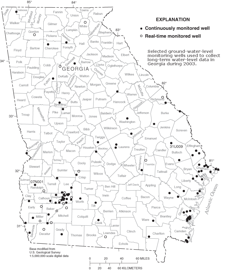 Selected ground-water-level monitoring wells used to collect long-term water-level data in Georgia during 2003.