
In cooperation with the Little St. Germain Lake District
Lake-Water Quality and the Effects of Winter Aeration
Streamflow and Stream-Water Quality
Water and Phosphorus Loading to Little St. Germain Lake
Effects of Phosphorus Reductions
Figure 1. Drainage basin of Little St. Germain Lake, Vilas County, Wis.
Figure 2. Morphometry of Little St. Germain Lake, Vilas County, Wis.
Figure 3. Hydrologic features simulated with GFLOW analytic elements near L...
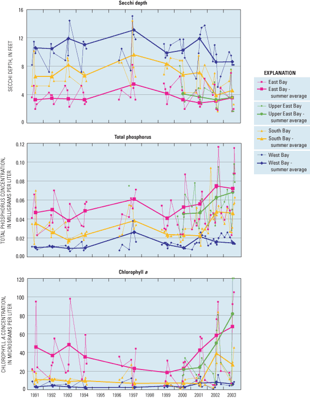
Figure 4. Measured Secchi depths, total phosphorus and Chlorophyll a concen...
Figure 5. Distribution of dissolved oxygen in Little St. Germain Lake, Vila...
Figure 6. Late winter vertical distribution of dissolved oxygen (February, ...
Figure 7. Distribution of dissolved oxygen in the Upper East Bay of Little ...
Figure 8. Distribution of dissolved oxygen in South and Second South Bays o...
Figure 9. Trophic state indices based on total phosphorus concentrations fo...
Figure 10. Flow and total phosphorus concentrations in Muskellunge Creek an...
Figure 11. Average total phosphorus concentrations in Muskellunge Creek and...
Figure 12. Schematic of the components of the water budget for Little St. G...
Figure 13. Monthly precipitation, inflow, outflow, and daily average water ...
Figure 14. Measured and simulated head for the calibrated GFLOW model for t...
Figure 15. Surface-water contributing area, simulated ground-water contribu...
Figure 16. Water budgets for Little St. Germain Lake, Vilas County, Wis. fo...
Figure 17. Phosphorus loading into and out of Little St. Germain Lake, Vila...
Figure 18. Phosphorus budgets for Little St. Germain Lake, Vilas County, Wi...
Table 1. Morphometry of Little St. Germain Lake and each of its basins, Vil...
Table 2. Monthly water budget for Little St. Germain Lake, for October 1, 1...
Table 3. Measured and simulated cumulative net ground-water discharge value...
Table 4. Monthly phosphorus budget, in pounds, for Little St. Germain Lake,...
Table 5. Simulated changes in average June through August near-surface tota...
Table 6. Simulated changes in June through August near-surface chlorophyll ...
| Multiply | By | To obtain |
|---|---|---|
| Length | ||
| inch (in.) | 2.54 | centimeter (cm) |
| inch (in.) | 25.4 | millimeter (mm) |
| foot (ft) | 0.3048 | meter (m) |
| mile (mi) | 1.609 | kilometer (km) |
| Area | ||
| acre | 4,047 | square meter (m2) |
| acre | 0.004047 | square kilometer (km2) |
| square mile (mi2) | 2.590 | square kilometer (km2) |
| Volume | ||
| cubic foot (ft3) | 0.02832 | cubic meter (m3) |
| acre-foot (acre-ft) | 1,233 | cubic meter (m3) |
| Flow rate | ||
| cubic foot per second (ft3/s) | 0.02832 | cubic meter per second (m3/s) |
| Mass | ||
| pound, avoirdupois (lb) | 0.4536 | kilogram (kg) |
| Hydraulic conductivity | ||
| foot per day (ft/d) | 0.3048 | meter per day (m/d) |
Temperature, in degrees Celsius (°C) can be converted to degrees Fahrenheit (°F) as follows:
°F = [1.8 x °C] + 32.
Specific conductance is given in microsiemens per centimeter at 25 degrees Celsius (µS/cm at 25°C).
Concentrations of chemical constituents in water are given either in milligrams per liter (mg/L) or micrograms per liter (µg/L).
Sea Level: In this report, "sea level" refers to the National Geodetic Vertical Datum of 1929 (NGVD of 1929) – a geodetic datum derived from a general adjustment of the first-order level of both the United States and Canada, formerly called Sea Level Datum of 1929.
Herbert S. Garn, Assistant Center Director, U.S. Geological Survey, Middleton, Wis.
Thomas C. Winter, Hydrologist, U.S. Geological Survey, Denver, Col.
Stephen Sward, Ted Ritter, Ron Mackowski, and Ervin Stiemke, Little St. Germain Lake District, St. Germain, Wis.
Michael Eberle, Technical Publications Editor, U.S. Geological Survey, Columbus, Ohio
Jennifer L. Bruce, Geographer, U.S. Geological Survey, Middleton, Wis.
Michelle M. Greenwood, Cartographer, U.S. Geological Survey, Middleton, Wis.
Leah N. Hout, Editor, U.S. Geological Survey, Columbus, Ohio
James M. Gerhart, U.S. Geological Survey, Baltimore, Md.
Little St. Germain Lake is a 978-acre, multibasin lake in Vilas County, Wisconsin. In the interest of protecting and improving the water quality of the lake, the Little St. Germain Lake District initiated several cooperative studies with the U.S. Geological Survey between 1991 and 2004 to (1) document the water quality and the extent of winter anoxia in the lake, (2) evaluate the success of aerators at eliminating winter anoxia, (3) develop water and nutrient budgets for the lake, and (4) assess how the water quality of the lake should respond to changes in phosphorus loading. This report presents the results of these cooperative studies with special emphasis on the water quality in the lake since 2000, including the effects of winter aeration and the importance of ground-water contributions of phosphorus to the productivity of the lake.
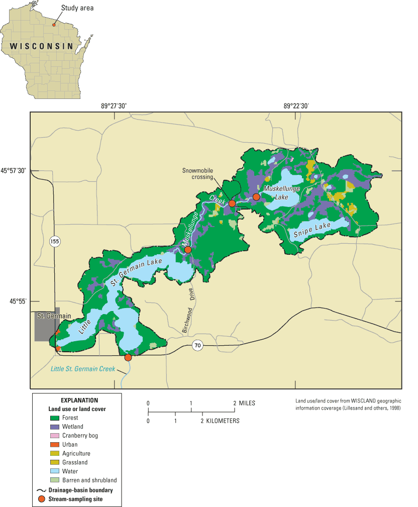
Figure 1. Drainage basin of Little St. Germain Lake, Vilas County, Wis.
Measurements collected during these studies indicate that the water quality in Little St. Germain Lake was consistently different among basins. The West Bay consistently had the best water quality, the South Bay had intermediate water quality, and the East and Upper East Bays consistently had the worst water quality. The water quality in each of the basins was relatively stable from 1991 to 2000; however, since 2001, the West Bay has changed from oligotrophic to mesotrophic, the South Bay has changed from mesotrophic to eutrophic, and the East and Upper East Bays have changed from eutrophic to eutrophic/hypereutrophic.
Winter anoxia frequently occurred throughout most of the lake, except in the West Bay and just below the ice in the East Bay. To eliminate winter anoxia, coarse-bubble line aerators were installed and operated in the Upper East, East, and South Bays. The aerators in the Upper East and South Bays were very successful at eliminating winter anoxia; however, the aerator in the East Bay had little impact on the dissolved oxygen concentrations throughout its basin.
Detailed water and phosphorus budgets computed for the lake indicated that inflow from Muskellunge Creek was the major source of phosphorus to the lake and that ground water was the secondary source. Results from a detailed ground-water-flow model indicated that ground water flows into the lake from all sides, except the south sides of the West and Second South Bays. Most of the phosphorus appears to come from natural sources, such as ground water and surface water flowing through relatively undeveloped areas surrounding Little St. Germain Lake and Muskellunge Lake.
Several empirical water-quality models were used to simulate how the East and Upper East Bays of the lake should respond to reductions in phosphorus loading from Muskellunge Creek. Simulation results indicated that reductions in tributary loading could improve the water quality of the East and Upper East Bays. Improving the water quality of these bays would also improve the water quality of the South and Second South Bays because of the flow of water through the lake. However, even with phosphorus loading from Muskellunge Creek completely eliminated, most of the lake would remain borderline mesotrophic/eutrophic because of the contributions of phosphorus from ground water.
Little St. Germain Lake, located just northeast of St. Germain in Vilas County, Wisconsin (fig. 1), is one of 21 impoundments operated by Wisconsin Valley Improvement Company (WVIC) to provide storage for power and for recreational use. The level of the lake, which was originally dammed in 1882, has been maintained by the WVIC at about 5 ft above its natural level since 1929, and it is annually drawn down about 1.5 ft from December through March. In the interest of protecting and improving the water quality of the lake, the Little St. Germain Lake District has collaborated with the Wisconsin Department of Natural Resources (WDNR) and the U.S. Geological Survey (USGS) to conduct several water-quality studies. From 1983 to 1985, the WDNR examined the water quality of the lake and various management alternatives (Wisconsin Department of Natural Resources, 1985). Results of the study indicated that, because of relatively high loading of phosphorus to the lake, most of the lake was eutrophic (based on relatively high chlorophyll a concentrations), with the possible exception of the West Bay. The results also indicated that monitoring of the lake should continue and that actions should be taken to decrease the nutrient loading to the lake by controlling erosion, fertilizer runoff, and leakage from septic systems.
The lake was monitored in detail during 1991–94 by the USGS as part of a cooperative study with the Little St. Germain Lake District. The study demonstrated variation in water quality among the various basins of the lake and found extensive areas of winter anoxia (absence of oxygen). Further in-depth studies were done by the USGS during 1994–2000 to refine the water and phosphorus budgets of the lake, quantify the effects of annual drawdowns, define the extent of winter anoxia, and provide information needed to develop a comprehensive lake-management plan (Robertson and Rose, 2000). Results of the study indicated that Muskellunge Creek was the dominant source of phosphorus to the lake; however, ground-water contributions (based on limited information) appeared to be important and should be better quantified. The results of the study also indicated extensive areas of winter anoxia in the Upper East, South, and Second South Bays (fig. 2). As a result of that study, aerators were placed in the Upper East Bay, the South Bay, and in the northern end of the East Bay and operated throughout the winter.
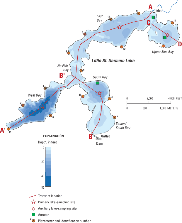
Figure 2. Morphometry of Little St. Germain Lake, Vilas County, Wis.
The USGS, in cooperation with the Little St. Germain Lake District, continued to study Little St. Germain Lake from 2000 to 2004. The goals of this effort were to (1) continue to document the water quality in the lake, (2) evaluate the success of the aerators at eliminating winter anoxia, (3) refine the nutrient budget of the lake by better quantifying flow and phosphorus contributions from ground water directly entering the lake and entering by way of Muskellunge Creek during November 1, 2000, to October 31, 2001, and (4) assess how the water quality of the lake should respond to changes in phosphorus loading. To better define the contributions from ground water (locations and amounts), a ground-water-flow model was developed for the Little St. Germain area. This report presents the results of the studies since 1991, with special emphasis on the water quality in the lake since 2000–including the effects of winter aeration and the importance of ground-water contributions of phosphorus to the productivity of the lake.
Little St. Germain Lake (fig. 1) is a multibasin lake with a total surface area of 978 acres and volume of 11,498 acre-ft (table 1). In this report, the lake is discussed in terms of six basins or "bays" (fig. 2 and table 1): Upper East Bay (119 acres), East Bay (336 acres), No Fish Bay (69 acres), West Bay (213 acres), South Bay (122 acres), and Second South Bay (119 acres). The major tributary to the lake is Muskellunge Creek, which flows about 3 mi from shallow, eutrophic Muskellunge Lake into the north end of the East Bay (fig. 2). Muskellunge Lake was extensively studied by the USGS during 2000–2001 as part of a cooperative study with the Muskellunge Lake Association (Robertson and others, 2003); results from that study are used to further describe the importance of ground water and contributions from natural sources to Little St. Germain Lake. Outflow from the lake is to Little St. Germain Creek, which leaves the south side of the Second South Bay and flows about 1 mi before draining into the Wisconsin River.
Table 1. Morphometry of Little St. Germain Lake and each of its basins, Vilas County, Wisconsin.
| Basin/Total | Maximum Depth (feet) | Mean Depth (feet) | Area (acres) | Volume (acre-feet) |
|---|---|---|---|---|
| Upper East | 15 | 7.5 | 119 | 893 |
| East | 12 | 8.9 | 336 | 2,982 |
| No Fish | 6 | 4.4 | 69 | 305 |
| West | 53 | 24.1 | 213 | 5,140 |
| South | 21 | 11.6 | 122 | 1,417 |
| Second South | 9 | 6.4 | 119 | 761 |
| Entire lake | 53 | 11.8 | 978 | 11,498 |
The total watershed area of Little St. Germain Lake is 10 mi2 (not including the lake itself). The watershed is predominantly forest (68 percent), wetland (17 percent), and water (8 percent), although areas of low-density residential development are increasing, especially immediately around the lakes (fig. 1). The soils in the watershed consist mainly of well-drained sand and sandy loams. These soils are thought to be naturally high in phosphorus content (Wisconsin Department of Natural Resources, 1985).
Data used to describe the water quality of the lake were collected from April 1991 to March 2004; however, no data were collected from September 1994 to July 1996 and September 1997 to February 1999. Lake water-quality properties were generally measured five times per year (late winter, May, June, July, and August) at three sites: the centers of the East, West, and South Bays (fig. 2). In addition, water-quality data were collected at the center of the Upper East Bay from 2000 to 2004. At all sites, depth profiles of water temperature, dissolved oxygen, specific conductance, and pH were measured during each visit with a multiparameter instrument. Water samples were collected at these sites at either or both near surface (1.5 ft below the surface during open water or just below ice during ice cover) or near bottom (1.5 ft above bottom) with a Van Dorn sampler. Near-surface water samples were analyzed for concentrations of total phosphorus (an indicator of the amount of available nutrients) and chlorophyll a (an indicator of the algal population). During ice-free periods, Secchi depths (an indicator of water clarity) also were measured. During spring overturns after ice out in 1991 through 1994, in 2002, and in 2003, surface-water samples were analyzed for a full suite of water-quality constituents in the South and West Bays.
Additional depth-profile measurements of temperature and oxygen were made at various locations during the winters of 1997–2004 to assess the extent and timing of anoxia before and during operation of the aerators. The most extensive set of profiles was collected in the basins in which aerators were placed: Upper East Bay, East, and South Bays (fig. 2).
Inflow and phosphorus loading to the lake were determined from flow measurements and water samples collected approximately monthly in Muskellunge Creek at Birchwood Drive (fig. 1) during October 1996–September 1997, December 1998–January 2000, and November 2000–October 2003. During 1996–97 and 1998–2000, flows between measurements were estimated by linearly interpolating between monthly measurements. Continuous (15-minute intervals) water-elevation measurements were collected at Birchwood Drive and the outlet of Muskellunge Lake from March 2001 through October 2001 to better describe the flow throughout Muskellunge Creek and better estimate the total phosphorus contributions from Muskellunge Creek. The monthly streamflow measurements were used to develop stage-discharge relations, which were then used in conjunction with water-elevation data to compute flow at these locations. During 1996–97, water samples collected at Birchwood Drive were analyzed for total phosphorus concentration. During 1998–99, water temperature and dissolved oxygen also were measured at Birchwood Drive, and the samples also were analyzed for dissolved phosphorus. During 1999–2003, water temperature and dissolved oxygen measurements were measured, and water-quality samples (analyzed for total and dissolved phosphorus) were collected approximately monthly at the Muskellunge Lake outlet (Robertson and others, 2003) and at the snowmobile crossing between the two lakes (fig. 1) to help define the sources of water and phosphorus to Muskellunge Creek.
Surface-water outflow from Little St. Germain Lake was estimated from water-elevation measurements made at the dam at Highway 70 by WVIC. Water levels at the dam on Little St. Germain Creek were monitored almost daily from 1991 to 2003 by the WVIC (U.S. Geological Survey, Wisconsin District Lake-Studies Team, 2004). Additional flow measurements and water samples were collected monthly just below the dam from December 1998 through September 2003 to better describe the outflow from the lake. Water samples were analyzed for total phosphorus. The flow measurements at the dam indicated that low flows were underestimated; therefore, those flows were adjusted accordingly.
Fifteen small, shallow piezometers (small-diameter observation wells) were installed approximately 1 to 3 ft below the water table around the lake (fig. 2) to help define areas contributing ground water to the lake, determine the phosphorus concentrations in the ground water entering the lake, and quantify the phosphorus loading from ground water. Ground-water gradient (determined from water elevation in the piezometer and the water elevation of the lake) and phosphorus concentrations in the ground water in each piezometer were measured two times: May and August 2001.
All chemical analyses of water samples were done by the Wisconsin State Laboratory of Hygiene in accordance with standard analytical procedures described in the "Manual of Analytical Methods, Inorganic Chemistry Unit" (Wisconsin State Laboratory of Hygiene, 1993).
Data collected during this study were published in two annual USGS data report series. Streamflow data were published in "Water Resources Data, Wisconsin–Water Year 2001" (Waschbusch and others, 2002) and lake data in the series "Water Quality and Lake-Stage Data for Wisconsin Lakes, Water Years 1994–2003" (the most recent Little St. Germain Lake data were published in U.S. Geological Survey, Wisconsin District Lake-Studies Team, 2004).
Coarse-bubble line aerators were installed in the Upper East and East Bays in fall 2001 (fig. 2) and operated during the winters of 2002, 2003, and 2004. (All winters are described in terms of the year in which the ice left the lake.) Each aerator is supplied by 5-horsepower blowers on the nearby shoreline. The air travels through 4-in. pipe out to the aerators, which were constructed of 2-in. pipe with 1/8-in. holes placed about 4 ft apart. The aerator in the East Bay is about 600 ft off the northwest shore at a depth of about 4 ft. This aerator was designed to release 42 ft3/min of air at 6 psi through two parallel 67-ft lines placed about 100 ft apart; each line has 16 holes. The aerator in Upper East Bay is near the center of the bay at a depth of about 10 to 12 ft. This aerator was designed to release 117 ft3/min of air at 10 psi through five parallel 75-ft lines about 100 ft apart; each line has 18 holes. A coarse-bubble line aerator was installed into the South Bay in fall 2002 (fig. 2) and operated during the winters of 2003 and 2004. The aerator in the South Bay is about 600 ft off the northwest shore at a depth of about 20 ft. This aerator was designed to release 117 ft3/min of air at 10 psi through five parallel 75-ft lines placed about 100 ft apart; each line has 18 holes. Each of the aerators is operated from shortly after ice formation until shortly before ice out.
The two-dimensional, analytic-element, steady-state, ground-water-flow model, GFLOW (Haitjema, 1995) was used to define ground-water-source areas around Little St. Germain Lake (and Muskellunge Lake) and to allocate ground-water discharge to shoreline segments represented by the piezometers installed around the lake. A complete description of analytic-element modeling is beyond the scope of this report; however, a brief description is given below. A complete discussion of the methods for applying the model can be found in Strack (1989) and Haitjema (1995).
An infinite aquifer is assumed in analytic-element modeling. In GFLOW, the study area (domain) does not require a grid or involve interpolation between cells. To construct an analytic-element model, features that affect ground-water flow (such as surface-water bodies, aquifer characteristics, and recharge) are entered as mathematical elements or strings of elements (described below). The amount of detail specified for the features depends on the distance from the area of interest. Each element is represented by an analytic solution. The effects of these individual solutions are added together to arrive at a solution for the ground-water-flow system. Because the solution is not confined to a grid, ground-water levels (heads) and flows can be computed anywhere in the study area without averaging values at specific locations in the model (nodal averaging). In the GFLOW model, the analytic elements are two dimensional and are used to simulate only steady-state conditions. Ground-water-flow systems are three dimensional; however, two-dimensional models can provide reasonable approximations of ground-water flowlines when the lengths of the flowlines are long compared to the aquifer thickness (Haitjema, 1995, p. 23). In the study area, most ground water was assumed to move through unconsolidated deposits that have a maximum saturated thickness of 200 ft or less. The lengths of flowlines from recharge areas to discharge areas are typically several thousand feet or more in length.
The GFLOW model for the study area covers an area extending approximately 4 to 7 mi around Little St. Germain Lake (fig. 3). The geometry of the single-layer model includes a bottom elevation set at 1,500 ft and an average aquifer thickness of 200 ft, which were based on well logs for the study area and additional information from Patterson (1989). Recharge was applied to the model area using an inhomogeneity element (an element with different aquifer properties from the rest of the study area). Surface-water features were simulated using several types of linesink elements. The model includes "far-field" and "near-field" sources and sinks of water (collectively referred to as linesinks; fig. 3). The far-field area surrounds the near-field area of interest. In the far field, streams are simulated as coarse linesinks having little or no resistance between the surface-water feature and the ground-water-flow system. The purpose of simulating the far field is to have the model explicitly define the regional ground-water-flow field near the area of interest. The near field represents the area of interest and includes Little St. Germain and Muskellunge Lakes and other adjacent lakes and streams (fig. 3). Base flows in near-field streams (Muskellunge Creek and Little St. Germain Creek near the lake outlet) were used to calibrate the model (flux calibration); flows in far-field streams were not. Near-field streams and lakes, in good connection with the ground-water-flow system, were included as linesinks with resistance.
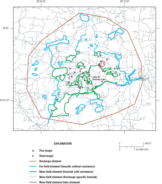
A constant value for stage was used for Little St. Germain Lake even though there was an annual stage fluctuation of about 1.5 ft. Cyclic fluctuations of this magnitude should have minimal effect on regional ground-water flow, and the net gains and losses to the ground-water-flow system immediately adjacent to the lake should be approximated by steady-state conditions on an annual basis. Muskellunge Lake was simulated with a special type of linesink with resistance, called a lake element, by use of the methodology described by Hunt and others (2003). The lake element solves for lake stage on the basis of simulated surface-water inflows and estimated surface-water outflows from the lake.
In analytic-element modeling, resistance is computed by dividing the bed-sediment thickness by the vertical hydraulic conductivity. For this model, resistance was set equal to 0.3 day for near-field streams, and 1.0 day for near-field lakes. These values are similar to sediment-resistance values used in other nearby GFLOW models (Hunt and others, 1998; Graczyk and others, 2003). Assigned stream widths ranged from 10 to 40 ft. The leakage length for near-field lakes was set equal to 64 ft and calculated by use of methods described by Hunt and others (2003). Perched or mounded lakes (such as Pincherry and Honeysuckle Lakes) were included as discharge-specified linesinks. The value assigned to discharge-specified linesinks limits the amount of water that can be added to the ground-water-flow system from perched lakes. The amount of discharge assigned to this type of linesink (8.9 in/yr) was computed from the long-term precipitation for the area (Hunt and others, 1998) minus evaporation (estimated in the section entitled "Water and Phosphorus Loading to Little St. Germain Lake", page 19).
Water quality in Little St. Germain Lake was consistently different among basins, except for a few water-quality characteristics (specific conductance and pH) that were similar throughout the lake but varied seasonally. Specific conductance ranged from about 75 µS/cm in summer to about 90 µS/cm in winter, and pH ranged from about 7 (in standard units) in winter to about 8 in summer.
Water clarity, based on Secchi-depth readings, was highly variable and ranged from about 1.5 ft in the East and Upper East Bays to more than 15 ft in the West Bay. The West Bay consistently had the greatest water clarity, which ranged from 5 to 15 ft (average summer, June through August, clarity ranged from 8.6 to 13.1 ft). The South Bay had intermediate clarity that ranged from 1.6 to 14 ft (average summer clarity from 3.9 to 9.6 ft). The East and Upper East Bays consistently had the least water clarity, which ranged from 1.6 to 8 ft (average summer clarity from 2.8 to 5.5 ft) (fig. 4). In the West Bay, water clarity was usually greatest in late summer; however, in the East and South Bays, it was usually greatest in early summer. The summer average water clarities in East, Upper East, and South Bays were less in 2002 and 2003 than in any other year measured. Water clarity in these basins in summer 2004 was comparable to 2002 and 2003 water clarity (Ron Mackowski, Little St. Germain Lake District, written commun., 2004).
The extent of thermal stratification differed among basins because of differences in the morphometries of the basins and limited circulation between basins. The West Bay, being relatively deep, consistently became strongly stratified during summer, with bottom temperatures remaining around 7–9°C. The South Bay, being moderately deep, became stratified during summer; however, in some years, stratification was frequently broken down by wind mixing. Because of the frequent deep mixing, bottom temperatures in the South Bay usually increased as summer progressed. Most of the rest of the lake is relatively shallow, which resulted in stratification being very weak in these areas, with seldom more than 2 or 3°C of stratification. During winter and without aeration, thermal stratification was weak but present throughout the entire water column in each of the basins. With aeration in the Upper East Bay and South Bay, little if any thermal stratification existed above the depth of the aerators; however, limited thermal stratification occurred below the depths of the aerators. The aerator in the East Bay, owing to its shallow depth, appeared to have little effect on the winter stratification in the center of the basin.
Thermal stratification during summer, which primarily occurred in the West and South Bays, isolated the deepest water from surface interactions. Thus, as summer progressed, dissolved oxygen concentrations in water below the thermocline decreased as a consequence of decomposition of dead algae and other organic matter that settled from the surface and the biochemical oxygen demand of the sediment. Water below about 25–30 ft in the West Bay usually became anoxic in late June and stayed anoxic throughout summer. In the South Bay, the variable strength of thermal stratification resulted in anoxia in the deepest water during summers when stratification was extensive and low oxygen concentrations during summers when mixing was more frequent. Anoxia seldom occurred in the other bays during summer because of frequent mixing.
Before freezing, the entire water column of most lakes is nearly saturated with oxygen; however, after a lake freezes and snow cover increases as winter progresses, oxygen can be quickly consumed, especially in shallow, productive lakes. This was the case in Little St. Germain Lake, especially in the shallower basins when aeration was not used. Oxygen depletion was much more severe during winter than during summer because of the lack of oxygen transfer through the surface as a result of the ice cover and because the snow cover reduced light penetration and therefore limited oxygen-producing photosynthesis. To demonstrate the spatial extent of oxygen depletion, transects of oxygen profiles were collected from the inlet to the outlet (A–B; fig. 2) and from the West Bay to the outlet (A'–B; fig. 2) in March 1997 (fig. 5) and March 1999. Detailed transects were collected in March because this was near to when oxygen depletion was expected to be most severe. Anoxia occurred in each of the basins, and by mid-March only small areas of the lake were habitable by most warm-water fish (areas with dissolved oxygen concentrations greater than about 2 mg/L, Barton and Taylor, 1996). These habitable areas include water down to depths of about 30 ft in the West Bay and down to about 5 ft in the East Bay. Without aeration, in most years, oxygen was almost completely consumed by mid-February in the Upper East, No Fish, South, and Second South Bays.
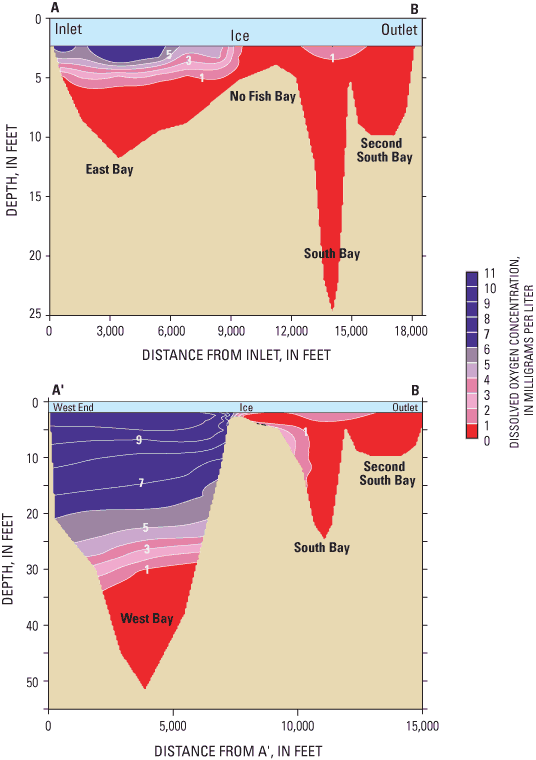
Water entering from Muskellunge Creek apparently may help alleviate the extent of late-winter anoxia in the East Bay. Although dissolved oxygen concentrations in Muskellunge Creek may be low in midwinter (less than 6 mg/L in February 1999 and possibly much lower in other years), concentrations can be high later in winter when parts of Muskellunge Creek are free of ice (greater than 10 mg/L in March 1999). Dissolved oxygen concentrations in the middle of the East Bay were lower in February 1997 than they were later in March 1997. This increase appears to be associated with cold, highly oxygenated water originating from Muskellunge Creek propagating across the basin (fig. 5). Dissolved oxygen concentrations in the Upper East Bay, which are not influenced by Muskellunge Creek inflow, did not increase from February to March. A detailed analysis of the flow in the lake demonstrated that the upper 3 ft of water (just below the ice) throughout the East Bay could be replaced by water from Muskellunge Creek in about 30 days.
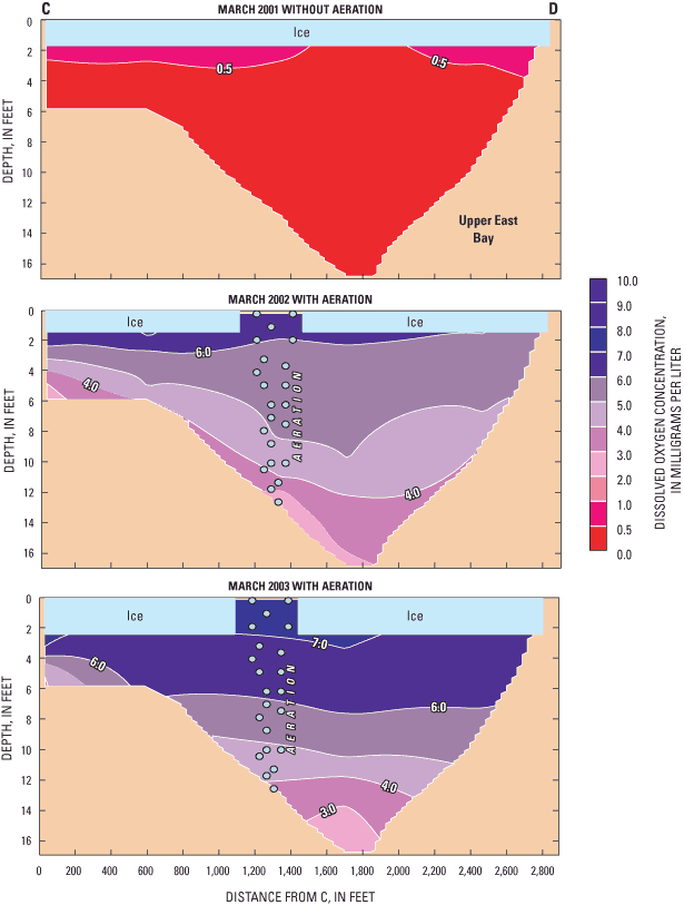
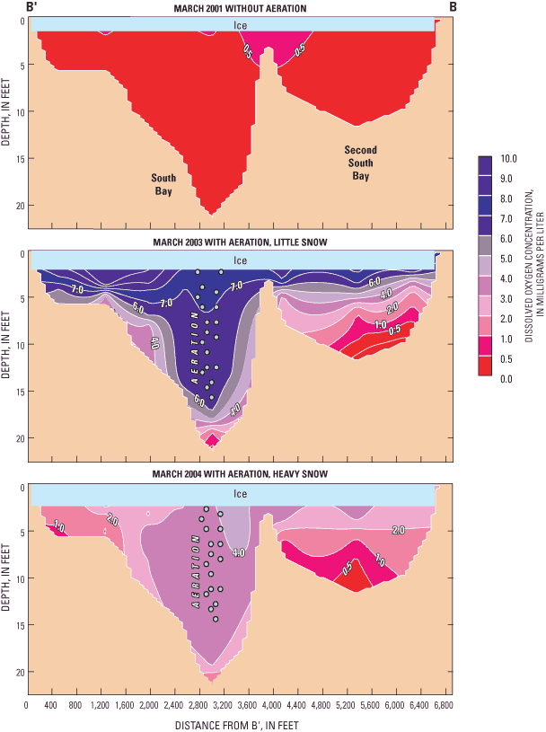
Aerators were operated in the East and Upper East Bays in the winters of 2002, 2003, and 2004, and operated in the South Bay in 2003 and 2004 to eliminate winter anoxia and the associated fish kills and odor problems near the outlet. Winter fish kills (referred to as "winterkills") usually result when dissolved oxygen concentrations throughout the lake drop below a critical concentration (usually considered below 2 mg/L; Wetzel, 1983). The success of the aerators at eliminating winter anoxia and the potential for fish kills can be evaluated by comparing oxygen profiles collected at the center of the basins (fig. 6) and oxygen transects collected across the basins (figs. 7 and 8) in late winter (March) in years with and without aeration. Each of the three years which the aerators were operated had distinct characteristics: 2002 had ice cover form later than normal, 2003 had very little snowfall, and 2004 had a more typical freeze date and relatively heavy snowfall. In 2002, the late ice formation should have resulted in delayed dissolved oxygen depletion. In 2003, there was very little snowfall, which resulted in thick clear ice that enabled light to penetrate into the water throughout most of the winter. This should have resulted in oxygen being depleted at a much slower rate than what typically occurs in Little St. Germain Lake because of oxygen production associated with algal and macrophyte productivity. Therefore, it is difficult to evaluate the effectiveness of the aerators at eliminating winter anoxia in 2003. The earlier freeze date and more snowfall in 2004 should have resulted in the most severe oxygen depletion and the best evaluation of the aerators during harsh winter conditions. More winterkills in nearby lakes were reported in 2004 than in most other years.
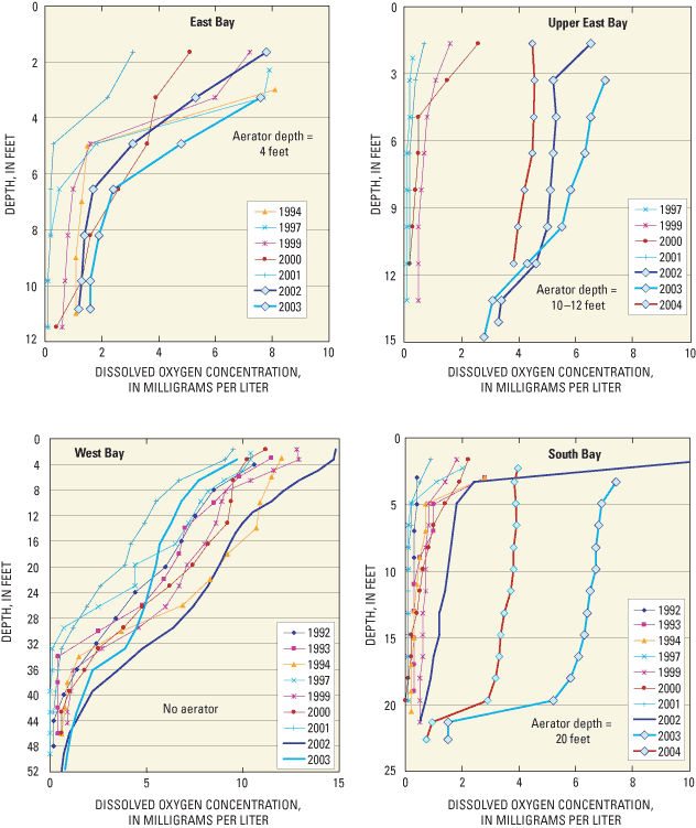
The aerator in the East Bay appeared to have minimal effect on the dissolved oxygen concentrations throughout the basin. The dissolved oxygen profile collected in 2002 at the center of the basin was very similar to those measured in 1994 and 2000 when aerators were not operated (fig. 6). The slightly higher dissolved oxygen concentrations in 2003 than in other years may have resulted from the very little snowfall that year. The ineffectiveness of the aerators may have been caused by being placed in water that was too shallow (approximately 4 ft) and (or) the aerator releasing too little air given the size of the East Bay.
The aerator in the Upper East Bay was very successful at eliminating winter anoxia and possible winterkills. In all three years of operation, dissolved oxygen concentrations remained above 3.5 mg/L throughout almost the entire water column, except below the depth of the aerators (fig. 6). Relatively high dissolved oxygen concentrations were found throughout the basin (fig. 7). Even during 2004, dissolved oxygen concentrations were above 4 mg/L throughout most of the water column. These concentrations were below the Wisconsin state standard of 5 mg/L for dissolved oxygen in warm-water lakes (Shaw and others, 1993) but were above the 2-mg/L critical concentration for most fish.
The aerator in the South Bay was very successful at eliminating winter anoxia and possible winterkills in the South and Second South Bays. In both years of operation, dissolved oxygen concentrations remained above 3 mg/L throughout almost the entire water column in the South Bay, except below the depth of the aerators where concentrations diminished sharply (fig. 6). Relatively high dissolved oxygen concentrations were found throughout most of the basin, but concentrations did diminish near the sediment surface (fig. 8). Even during the harsh winter of 2004, dissolved oxygen concentrations were above 3 mg/L throughout most of the water column. The movement of water with low dissolved oxygen concentrations from No Fish Bay to the South Bay resulted in lower dissolved oxygen concentrations on the northwest side of the South Bay, especially near the bottom (fig. 8).
The positive effects of the aerator in the South Bay were propagated downstream into the Second South Bay. The movement of water with relatively high dissolved oxygen concentrations from the South Bay into the Second South Bay increased dissolved oxygen concentrations in the water above the depth of the sill separating the two basins (fig. 8). The cooler, less dense water from the South Bay flowed over the warmer and more dense water below the sill depth in the Second South Bay. This resulted in a zone of oxygenated water (greater than 2 mg/L) just below the ice in the Second South Bay.
Phosphorus and nitrogen are essential nutrients for plant growth and are the nutrients that usually limit algal growth in Midwestern lakes. High nutrient concentrations can cause high algal populations (blooms) and can therefore be the cause of accelerated eutrophication (that is, accelerated aging and increased productivity) of lakes. The ratio of near-surface concentrations of total nitrogen to total phosphorus is often used to indicate which of these nutrients should potentially limit algal productivity in a lake. The specific value of this ratio that determines which nutrient is potentially limiting varies under different conditions such as water temperature, light intensity, and nutrient deficiencies (Corell, 1998); however, a ratio greater than about 12:1, by weight, usually indicates that phosphorus is the potentially limiting nutrient. Total nitrogen was measured only during spring overturn in the South and West Bays and once at the four main sampling sites in 2002; therefore, the nitrogen to phosphorus ratio could only be quantified at a few times. In July 2002, the nitrogen-to-phosphorus ratio ranged from about 10:1 in the East and Upper East Bays, to about 17:1 in the South Bay, to about 50:1 in the West Bay. These ratios are similar to those measured in the South and West Bays at spring overturn in 2002 and other years. Therefore, phosphorus should usually be the nutrient limiting algal growth in most of the lake (possibly co-limiting in the East and Upper East Bays) and the nutrient to focus on when considering management efforts to improve water quality.
Phosphorus concentrations at the surface ranged from 0.006 mg/L (West Bay) to 0.116 mg/L (East Bay) (fig. 4). The West Bay consistently had the lowest concentrations, which ranged from 0.006 to 0.038 mg/L (average summer concentrations from 0.009 to 0.026 mg/L; fig. 4). The South Bay had intermediate concentrations, which ranged from 0.012 to 0.094 mg/L (average summer concentrations from 0.018 to 0.048 mg/L). The East and Upper East Bays consistently had the highest concentrations, which ranged from 0.023 to 0.116 mg/L (average summer concentrations from 0.038 to 0.075 mg/L). Phosphorus concentrations were usually highest in late summer in the East and Upper East Bays; however, no consistent seasonal patterns were evident in the South and West Bays. The highest phosphorus concentrations were measured in 2002 and 2003 in all locations but the West Bay.
Phosphorus can be released from lake sediments, especially during periods of anoxia. Increased phosphorus concentrations just above the sediments primarily were observed in the West Bay during late summer, when the deep water was anoxic. Phosphorus concentrations typically reached 0.2–0.3 mg/L just above the bottom in late summer in the West Bay. Because of the variable strength of stratification in the South Bay and variable lengths of time with anoxia near the bottom, the buildup of phosphorus in the deep water was variable. In 2003, phosphorus concentrations were greater than 0.6 mg/L in August; however, in most years, phosphorus concentrations were similar to those measured near the surface because of mixing. Anoxia was seldom measured in the other bays during summer because of frequent and extensive mixing events, and therefore near-bottom phosphorus concentrations were very similar to those measured at the surface. Although anoxia was common under the ice, near-bottom phosphorus concentrations were not as great as during summer anoxia. Near-bottom concentrations of about 0.2 mg/L were measured in each of the basins, but only in the absence of aeration.
Chlorophyll a is a photosynthetic pigment found in algae and other green plants. Its concentration, therefore, is commonly used as a measure of the density of the algal population of a lake. In the northern part of Wisconsin, concentrations greater than 15 µg/L are usually considered to be high and are usually associated with algal blooms. Chlorophyll a concentrations ranged from less than 1 µg/L (West Bay) to greater than 100 µg/L (East and Upper East Bays) (fig. 4). Differences in chlorophyll a concentrations among basins directly coincided with the differences in the phosphorus concentrations among basins. Concentrations were commonly greater than 15 µg/L in the East and Upper East Bays and occasionally greater than 15 µg/L in the South Bay, but only once was a concentration greater than 15 µg/L observed in the West Bay. Average summer concentrations were highest in the East and Upper East Bays (from 18 to 82 µg/L), moderate in the South Bay (from 6 to 39 µg/L), and lowest in the West Bay (from 2 to 8 µg/L) (fig. 4). Chlorophyll a concentrations increased dramatically in all of the basins in 2002 and 2003, but especially in the South Bay.
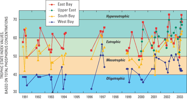
One method of classifying the water quality or productivity of lakes is by computing Trophic State Indices (TSIs). These indices, based on near-surface concentrations of total phosphorus and chlorophyll a and on Secchi depths (Carlson, 1977), place these three characteristics on similar scales. Oligotrophic lakes (TSIs less than 40) typically have a limited supply of nutrients and are typically clear; algal populations and phosphorus concentrations are low, and the deepest water is likely to contain oxygen throughout the year. Mesotrophic lakes (TSIs between 40 and 50) typically have a moderate supply of nutrients, are prone to moderate algal blooms, and have occasional oxygen depletions at depth. Eutrophic lakes (TSIs greater than 50) are nutrient rich with correspondingly severe water-quality problems, such as frequent seasonal algal blooms, oxygen depletion in lower parts of the lakes, and poor clarity. Lakes with TSIs greater than 60 are considered hypereutrophic and usually have extensive algal blooms throughout summer. These three indices are related to each other in complex ways that differ seasonally and among lakes. All three of the indices indicated that the East and Upper East Bays were eutrophic and often hypereutrophic, especially during 2002 and 2003 (fig. 9). For these basins, the average summer TSIs based on surface phosphorus ranged from 56 to 64, based on surface chlorophyll a ranged from 58 to 67, and based on Secchi depth ranged from 53 to 63. All three indices indicated that the South Bay was mesotrophic to eutrophic from 1991 to 2001 and eutrophic to hypereutrophic in 2002 and 2003 (average summer TSIs based on surface phosphorus, 45 to 60; based on surface chlorophyll a, 47 to 61; and based on Secchi depth, 45 to 60). All three indices indicated that the West Bay was usually oligotrophic prior to 2001 and mesotrophic from 2001 to 2003 (the average summer TSIs based on surface phosphorus, 35 to 50; based on surface chlorophyll a, 36 to 48; and based on Secchi depth, 40 to 47). Based on the indices, all of the basins were more eutrophic in 2002 and 2003 than in any of the other years monitored.
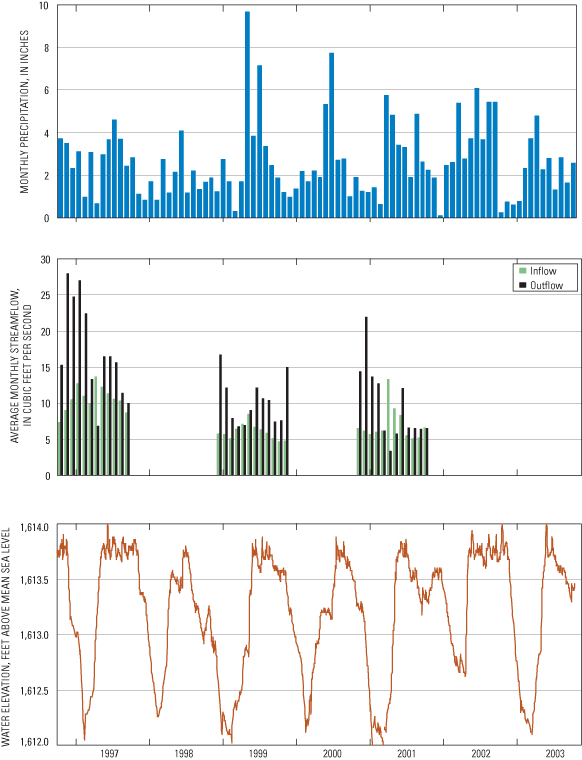
Streamflows for the three sites on Muskellunge Creek and the outlet from Little St. Germain Lake are shown in figure 10. Flow increases in Muskellunge Creek from the Muskellunge Lake outlet, to the snowmobile crossing, to Birchwood Drive. During 2001, the only year with true daily data from March through October, average streamflow increased from 3.1 ft3/s at the Muskellunge Lake outlet to 7.0 ft3/s at Birchwood Drive. There was little daily variability in Muskellunge Creek during 2001, which indicated that the interpolation between monthly measurements should be a relatively accurate means of computing daily flows for the other years for which daily data were not available. The average annual flow at Birchwood Drive in 2001 computed using the daily flows interpolated between the approximately monthly calibration data was 7.2 ft3/s compared to 7.0 ft3/s computed using daily measurements. Measurements throughout 1999 to 2003 indicate similar differences among sites. During 2001, the flow at the Little St. Germain Lake outlet was 9.7 ft3/s. Average annual flows into the lake (at Birchwood Drive) and out of the lake were highest in 1997 and were relatively similar in all other years. Flows were highest in Muskellunge Creek during spring; however, flow out of the lake was highest during the fall and early winter drawdown of the lake.
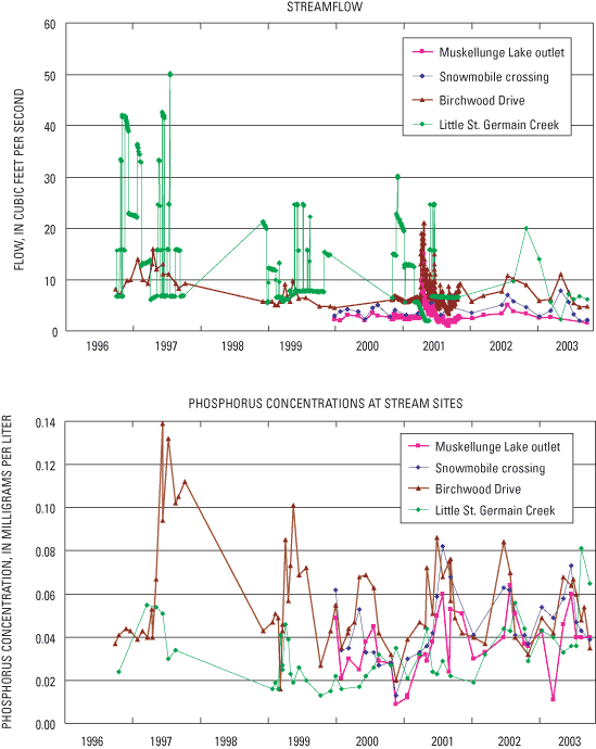
Phosphorus concentrations in Muskellunge Creek consistently increased from the Muskellunge Lake outlet to Birchwood Drive (figs. 10 and 11). Concentrations at all of the sites were highest during summer and lowest during winter. Phosphorus concentrations at the Muskellunge Lake outlet ranged from about 0.009 mg/L in the winter to about 0.06 mg/L in summer. Phosphorus concentrations at Birchwood Drive ranged from 0.016 mg/L in winter of 2000 to 0.14 mg/L during summer 1997. Phosphorus concentrations at the snowmobile crossing were between those of these two sites, but generally were more similar to those at the Muskellunge Lake outlet. Phosphorus concentrations at Birchwood Drive were much higher in 1997 than during any other time, especially in midsummer to late summer. The high concentrations in 1997 may have been due to effects of beaver activity on Muskellunge Creek. Ponding of water behind beaver dams may have resulted in a high release of phosphorus from the organic-rich wetland sediments that are not otherwise inundated with water.
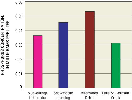
Concentrations at the Little St. Germain Lake outlet usually were lower than those entering the lake and ranged from 0.013 to 0.081 mg/L. The highest concentrations were measured in 2002 and 2003, coinciding with the high concentrations in the South Bay. The average total phosphorus concentration for 1999 to 2003 (fig. 11) increased from 0.036 mg/L at the Muskellunge Lake outlet, to 0.045 mg/L at the snowmobile crossing, to 0.053 mg/L at Birchwood Drive. Phosphorus concentrations in Muskellunge Creek are high considering that most of the watershed of Little St. Germain Lake is relatively pristine (fig. 1). The high concentrations may be the result of leaching from the soils that are thought to be rich in phosphorus in this area (Wisconsin Department of Natural Resources, 1985). The average total phosphorus concentration of the water leaving the lake during this period was 0.031 mg/L.
From 1999 through 2003, the dissolved phosphorus concentrations in Muskellunge Creek ranged from 0.013 to 0.045 mg/L, representing about 55 percent of the phosphorus in the creek. The average dissolved phosphorus concentration at Birchwood Drive was 0.027 mg/L. The average dissolved phosphorus concentration at this site during May through August was 0.033 mg/L, representing about 53 percent of the phosphorus.
Because the productivity in Little St. Germain Lake should potentially be limited by the input of phosphorus (based on nitrogen-to-phosphorus ratios), reduction in phosphorus input to the lake would be a logical management goal. Most phosphorus that enters lakes is associated with the input of water. Therefore, to determine where the water and phosphorus originates and how changes in phosphorus loading should affect the trophic status of the lake, the water and phosphorus budgets of the lake were quantified. Water and phosphorus budgets were computed on a monthly basis for three different annual periods: the period from October 1, 1996, to September 30, 1997 (referred to as monitoring year 1997; MY1997); the period from December 1, 1998, to November 30, 1999 (referred to as MY1999); and the period from November 1, 2000, to October 31, 2001 (referred to as MY2001). Water and phosphorus budgets were constructed as part of the earlier study on the lake (Robertson and Rose, 2000). That study indicated that phosphorus from Muskellunge Creek was the dominant source of phosphorus; however, ground-water contributions also were important and needed to be better quantified. Therefore, the water and phosphorus budgets for 2001 were computed with greater detail, especially regarding the inputs from ground water. This information was used to refine the budgets of the earlier study.
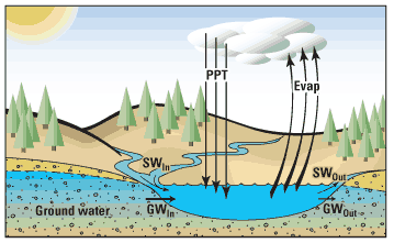
The hydrology of Little St. Germain Lake can be described in terms of components of its water budget (fig. 12). The water budget for the lake may be represented by the equation
ΔS = (PPT + SWIn + GWIn) – (Evap + SWOut + GWOut) (1)
where ΔS is the change in the volume of water stored in the lake during the period of interest and is equal to the sum of the volumes of water entering the lake minus the sum of the volumes leaving the lake. Water enters the lake as precipitation (PPT), surface-water inflow (SWIn), and ground-water inflow (GWIn). Water leaves the lake through evaporation (Evap), surface-water outflow (SWOut), and ground-water outflow (GWOut).
Changes in lake volume were determined from water elevations monitored at the outlet dam near Highway 70 (fig. 1) and the morphometry of the lake, assuming a constant surface area of the lake. Lake stage fluctuated from a minimum elevation of 1,611.9 ft to a maximum of 1,614.0 ft (fig. 13). Typically, the lake stage was relatively stable from May through mid-November, lowered about 1.5 ft between mid November and early February, and remained relatively stable until mid-March before again filling to its summer level. The lake stage at the end of MY1997 was similar to that at the beginning of the period; therefore, the change in storage was only 59 acre-ft (table 2). The lake stage at the end of MY1999 was about 0.6 ft higher than at the beginning of that year and resulted in a change in storage of 529 acre-ft. The lake stage at the end of MY2001 period was about 0.3 ft higher than at the beginning of that year and resulted in a change in storage of 326 acre-ft.
[ft3/s, cubic feet per second. Numbers may not add exactly to totals due to rounding. Totals for rates in ft3/s are means.]
| Month | Precipitation | Evaporation | Muskellunge Creek input | Change in storage | Net ground- water input | Ground- water input | Ground- water output | Outlet | |||||
|---|---|---|---|---|---|---|---|---|---|---|---|---|---|
| inches | acre-feet | inches | acre-feet | ft3/s | acre-feet | acre- feet | ft3/s | acre-feet | acre- feet | acre- feet | ft3/s | acre-feet | |
| October 1, 1996, to September 30, 1997 (MY1997) | |||||||||||||
| Oct. | 3.7 | 305 | 1.9 | 153 | 7.4 | 456 | 39 | 6.1 | 375 | 425 | 49 | 15.3 | 944 |
| Nov. | 3.5 | 287 | 0.4 | 33 | 9.0 | 539 | -431 | 7.5 | 443 | 502 | 58 | 28.0 | 1,668 |
| Dec. | 2.3 | 189 | 0.0 | 0 | 10.5 | 647 | -343 | 5.7 | 348 | 393 | 46 | 24.8 | 1,527 |
| Jan. | 3.1 | 255 | 0.0 | 0 | 12.8 | 789 | -500 | 2.0 | 123 | 139 | 16 | 27.0 | 1,666 |
| Feb. | 1.0 | 79 | 0.0 | 0 | 11.0 | 613 | -176 | 6.9 | 382 | 433 | 50 | 22.5 | 1,250 |
| Mar. | 3.1 | 252 | 0.0 | 0 | 10.0 | 614 | 305 | 4.2 | 260 | 294 | 34 | 13.3 | 821 |
| Apr. | 0.7 | 56 | 1.0 | 83 | 13.7 | 816 | 949 | 9.6 | 570 | 645 | 75 | 6.9 | 410 |
| May | 3.0 | 243 | 3.8 | 310 | 12.3 | 756 | 196 | 8.5 | 521 | 589 | 68 | 16.5 | 1,015 |
| June | 3.7 | 300 | 4.3 | 350 | 11.4 | 679 | 20 | 6.3 | 372 | 421 | 49 | 16.5 | 982 |
| July | 4.6 | 376 | 4.4 | 361 | 10.6 | 654 | -39 | 4.2 | 256 | 290 | 34 | 15.7 | 965 |
| Aug. | 3.7 | 302 | 3.7 | 305 | 10.4 | 640 | 59 | 2.0 | 126 | 142 | 17 | 11.4 | 704 |
| Sept. | 2.4 | 199 | 2.8 | 230 | 8.7 | 519 | -20 | 1.6 | 92 | 104 | 12 | 10.1 | 600 |
| Total | 34.8 | 2,844 | 22.4 | 1,825 | 10.6 | 7,722 | 59 | 5.3 | 3,869 | 4,377 | 508 | 17.3 | 12,552 |
| December 1, 1998, to November 30, 1999 (MY1999) | |||||||||||||
| Dec. | 1.2 | 100 | 0.0 | 0 | 5.8 | 358 | -372 | 3.3 | 203 | 230 | 27 | 16.8 | 1,033 |
| Jan. | 2.7 | 224 | 0.0 | 0 | 5.7 | 352 | -176 | -0.4 | -27 | 0 | 27 | 11.8 | 725 |
| Feb. | 1.7 | 140 | 0.0 | 0 | 4.6 | 285 | 284 | 6.3 | 348 | 394 | 46 | 7.9 | 489 |
| Mar. | 0.3 | 26 | 0.0 | 0 | 6.5 | 400 | 127 | 1.9 | 118 | 134 | 16 | 6.8 | 418 |
| Apr. | 1.7 | 139 | 1.0 | 83 | 6.9 | 426 | 313 | 3.7 | 219 | 248 | 29 | 6.3 | 388 |
| May | 9.7 | 790 | 3.8 | 310 | 8.5 | 526 | 862 | 6.7 | 413 | 467 | 54 | 9.3 | 573 |
| June | 3.8 | 314 | 4.3 | 350 | 6.5 | 401 | -157 | 3.4 | 205 | 232 | 27 | 11.5 | 711 |
| July | 7.2 | 585 | 4.4 | 361 | 6.4 | 393 | 274 | 5.2 | 319 | 361 | 42 | 10.7 | 661 |
| Aug. | 3.4 | 274 | 3.7 | 305 | 5.9 | 361 | -196 | 1.6 | 98 | 111 | 13 | 8.9 | 547 |
| Sept. | 2.5 | 202 | 2.8 | 230 | 5.0 | 307 | -78 | 1.7 | 101 | 115 | 13 | 8.7 | 536 |
| Oct. | 1.9 | 153 | 1.9 | 153 | 4.7 | 290 | 20 | 3.3 | 201 | 227 | 26 | 7.7 | 472 |
| Nov. | 1.2 | 98 | 0.4 | 33 | 4.6 | 285 | -372 | 2.9 | 172 | 194 | 23 | 14.5 | 893 |
| Total | 37.3 | 3,045 | 22.4 | 1,825 | 6.0 | 4,383 | 529 | 3.3 | 2,371 | 2,712 | 341 | 10.3 | 7,445 |
| November 1, 2000, to October 31, 2001 (MY2001) | |||||||||||||
| Nov. | 1.9 | 155 | 0.4 | 33 | 6.3 | 389 | -202 | 2.5 | 148 | 167 | 19 | 14.0 | 861 |
| Dec. | 1.3 | 104 | 0.0 | 0 | 6.2 | 382 | -846 | 0.3 | 21 | 24 | 3 | 22.0 | 1,353 |
| Jan. | 1.2 | 100 | 0.0 | 0 | 5.7 | 352 | 49 | 7.2 | 441 | 499 | 58 | 13.7 | 843 |
| Feb. | 1.4 | 117 | 0.0 | 0 | 5.5 | 337 | -215 | 0.7 | 40 | 45 | 5 | 11.5 | 709 |
| Mar. | 0.6 | 53 | 0.0 | 0 | 6.2 | 381 | 411 | 5.8 | 358 | 405 | 47 | 6.2 | 381 |
| Apr. | 5.7 | 469 | 1.0 | 83 | 12.9 | 795 | 1,136 | 2.6 | 157 | 178 | 21 | 3.3 | 202 |
| May | 4.8 | 394 | 3.8 | 310 | 9.2 | 570 | 215 | -1.3 | -79 | 0 | 79 | 5.8 | 359 |
| June | 3.4 | 281 | 4.3 | 350 | 8.1 | 499 | -78 | 3.6 | 215 | 243 | 28 | 11.7 | 722 |
| July | 3.3 | 270 | 4.4 | 361 | 5.6 | 343 | -176 | -0.3 | -19 | 0 | 19 | 6.6 | 409 |
| Aug. | 1.9 | 156 | 3.7 | 305 | 5.2 | 318 | -215 | 0.3 | 21 | 24 | 3 | 6.6 | 405 |
| Sept. | 4.9 | 398 | 2.8 | 230 | 5.0 | 311 | 0 | -1.5 | -92 | 0 | 92 | 6.3 | 387 |
| Oct. | 2.6 | 216 | 1.9 | 153 | 6.6 | 409 | 248 | 2.9 | 178 | 201 | 23 | 6.5 | 402 |
| Total | 33.2 | 2,713 | 22.4 | 1,825 | 7.0 | 5,084 | 326 | 1.9 | 1,389 | 1,786 | 397 | 9.7 | 7,034 |
Precipitation was measured by a weather observer near St. Germain, Wis. (fig. 13). During these three periods, precipitation (in inches) ranged from 33.2 in MY2001, to 34.8 in MY1997, to 37.3 in MY1999 (table 2). Evaporation from the lake was estimated from average monthly evaporation-pan data from 7 years of data collected at the Rainbow Flowage, which is about 15 mi west of Little St. Germain Lake. Monthly lake/pan coefficients computed as part of a study on Vandercook Lake, Vilas County (Wentz and Rose, 1991), were then used to adjust the pan evaporation rates to obtain total lake evaporation. These coefficients ranged from 0.75 in May to 1.17 in October. No evaporation was assumed to occur when the lake was ice covered. About 22 in. of water (1,825 acre-ft) was estimated to have evaporated from the lake during each period (table 2), most of this during summer. It was assumed that the monthly evaporation was the same each year.
Surface-water inflow to the lake was measured at Birchwood Drive on Muskellunge Creek (fig. 13). It was assumed that there was no surface-water inflow to the lake downstream from Birchwood Drive. Any surface-water inflow downstream from this point was incorporated into ground-water inflow. Daily average flows at Birchwood Drive were computed by linearly interpolating between monthly measurements in MY1997 and MY1999. In MY2001, daily average flows were computed by linearly interpolating between monthly measurements from November through February and from the 15-minute flow data for March through October. Average annual inflow ranged from 10.6 ft3/s (7,722 acre-ft) in MY1997, to 7.0 ft3/s (5,084 acre-ft) in MY2001, to 6.0 ft3/s (4,383 acre-ft) in MY1999. Inflow to the lake in MY1997 was about 1.8 times that in MY1999 even though there was less precipitation in MY1997. This demonstrates that the flow in Muskellunge Creek is driven by long-term changes in precipitation and ground-water inflow rather than short-term fluctuations.
The average flow out of the lake was 17.3 ft3/s (12,552 acre-ft) in MY1997, 10.3 ft3/s (7,445 acre-ft) in MY1999, and 9.7 ft3/s (7,034 acre-ft) in MY2001 (table 2). Outflow from the lake in MY1997 also was higher than in MY1999 even though there was less precipitation in MY1997, which again demonstrates that long-term changes in precipitation and ground-water inflow are important to the hydrology of Little St. Germain Lake. In all three years, outflow from the lake was about 1.4 to 1.7 times greater than the input from Muskellunge Creek.
After converting all of the hydrologic components in the water budget equation (eq. 1) into acre-ft and solving for net ground-water input (GWIn – GWOut), it was estimated that there was a net ground-water input to Little St. Germain Lake of about 3,900 acre-ft (5.3 ft3/s) in MY1997, 2,400 acre-ft (3.3 ft3/s) in MY1999, and 1,400 acre-ft (1.9 ft3/s) in MY2001 (table 2). In order to better define the contributions from ground water (locations and input and output amounts) a ground-water-flow model was developed for the Little St. Germain Lake watershed based on the flow conditions in MY2001.
Ground-water gradients from the 15 piezometers installed around the lake (fig. 2), water levels in wells and lakes in the area, flows at the Muskellunge Lake outlet, Birchwood Drive, and the Little St. Germain Lake outlet were used to calibrate the ground-water-flow model, GFLOW (Haitjema, 1995). The model was then used to define ground-water-source areas around Little St. Germain Lake (and Muskellunge Lake) and to allocate ground-water discharge to the shoreline segments represented by the piezometers.
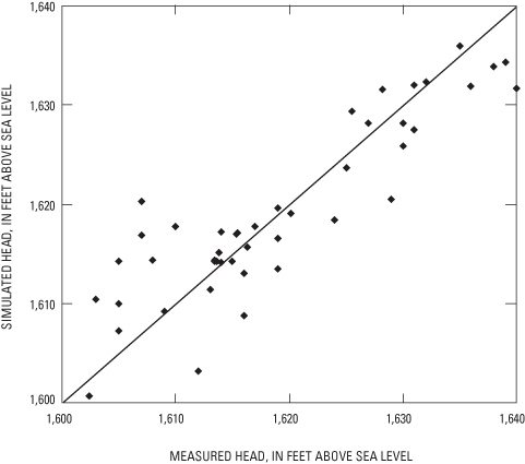
The GFLOW model was calibrated by varying horizontal hydraulic conductivity and ground-water recharge within an expected range until there was a reasonable match between measured and simulated ground-water levels and base flows for streams in the near field. Areal recharge to the ground-water-flow system was set equal to 8.9 in/yr, and horizontal hydraulic conductivity was set equal to 28 ft/d for the calibrated model. These values are similar to those used by Hunt and others (1998). For 46 water-level targets (fig. 3), the calibrated model had a mean difference between measured and simulated water levels of 0.1 ft and mean absolute difference of 3.6 ft (fig. 14).
Simulated cumulative net ground-water discharges were within 0.4 ft3/s of independently determined cumulative net ground-water discharges at the Muskellunge Lake outlet, at Muskellunge Creek at Birchwood Drive, and at Little St. Germain Creek at Highway 70 in MY2001 (table 3). Net ground-water discharge to Muskellunge Lake was determined as the residual in the water-budget equation (2.46 ft3/s; 1.87 ft3/s from eq. 1 plus 0.59 ft3/s, the estimated ground-water discharge to the southeast tributary of Muskellunge Lake that was included in the discharge simulated by the ground-water-flow model; Robertson and others, 2003). The total net ground-water discharge at Birchwood Drive (5.69 ft3/s) was estimated by adding the ground-water discharge to Muskellunge Creek (3.23 ft3/s, estimated by subtracting the daily outflow from Muskellunge Lake from the total flow measured at Birchwood Drive and by use of a graphical base-flow separation analysis on the difference between these two sites to determine surface runoff) to that estimated at the Muskellunge Lake outlet. The total net ground-water discharge at Highway 70 was estimated by adding the net ground-water input to Little St. Germain Lake from table 2 (1.9 ft3/s) to the net ground-water discharge at Birchwood Drive. Simulated net ground-water discharges in table 3 were obtained by removing precipitation minus evaporation on the surfaces of Muskellunge Lake (0.28 ft3/s) and Little St. Germain Lake (1.004 ft3/s) from the model estimates.
[ft3/s, cubic feet per second; in/yr, inches per year; MY, monitoring year]
| Comparison site | Cumulative net ground-water discharge (ft3/s) | |
|---|---|---|
| Independently determined values for MY2001 | Model-simulated values* | |
| Muskellunge Lake at the outlet | 2.46 | 2.20 |
| Muskellunge Creek at Birchwood Drive | 5.69 | 5.32 |
| Little St. Germain Lake outlet at Highway 70 | 7.79 | 8.12 |
* Simulated net ground-water discharge values from the lakes were modified from the actual model output by subtracting precipitation minus evaporation (8.9 in/yr) applied to the lake surfaces. For Muskellunge Lake and Muskellunge Creek, 0.28 ft3/s was subtracted, and for the Little St. Germain Lake outlet at Highway 70, 1.284 ft3/s was subtracted.
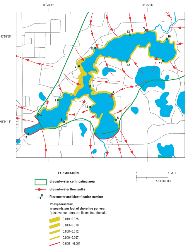
The ground-water contributing area for Little St. Germain Lake was delineated using particle tracking techniques in GFLOW. The area contributing ground water to the lake (14.1 mi2) is different and slightly larger than the area contributing surface water (10 mi2; 11.5 mi2 if the lake surface is included)(fig. 15). The model results indicated that ground water discharges into the lake from all sides except for two small areas at the south ends of the Second South and West Bays. Water levels (heads) measured in piezometers indicated that some parts of the lake alternate between contributing and losing ground water at different times of the year. During May and June 2001, water levels measured at 13 piezometers indicated that ground water flowed into the lake on all sides except the south side of West Bay, where it was leaving the lake. During August and September 2001, water-level measurements at 15 piezometers indicated that ground-water discharged into all sides of the lake except the south side of the West Bay, the northeast side of the South Bay, and the south side of the East Bay. No piezometers were installed near the outlet of the lake in an area simulated as losing water. Most of the urban development around the southwest part of the West Bay and along Highway 70 is in areas that do not contribute ground water to the lake.
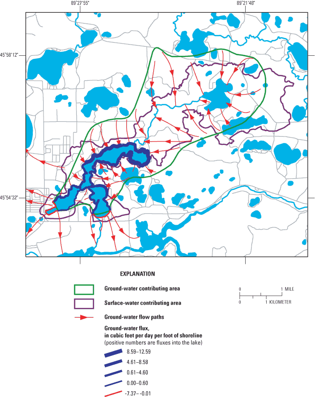
The simulated ground-water fluxes into and out of the lake were calculated for 16 shoreline segments. The segment lengths correspond to the length of shoreline halfway between adjacent piezometers installed around the lake (fig. 2), except for the segment representing the south end of the South Bay. No piezometers were installed in this area; therefore, the segment between piezometers in the South and Second South Bays was divided into two segments, one of which represents the shoreline near the lake outlet that was simulated to lose water to the ground-water-flow system. The amount of ground water entering the lake through each shoreline segment is shown in figure 15 by the thickness of the segment lines around the lake. The ground-water flux into the lake ranged from 0.4 ft3/day per foot of shoreline (West Bay near piezometer 3, close to where water is lost to the ground-water-flow system) to 12.6 ft3 per day per foot of shoreline (near piezometer 13, along the north shore of East Bay). Ground-water fluxes out of the lake ranged from 2.5 to 7.4 ft3 per day per foot of shoreline, in the West and Second South Bays, respectively.
The total annual simulated ground-water flow into Little St. Germain Lake (GWIn) was 2.65 ft3/s (based on summing contributions of shoreline segments contributing ground water to the lake), and the total annual simulated loss from the lake to the ground-water-flow system (GWOut) was 0.30 ft3/s (based on summing shoreline segments gaining water from the lake). The net annual ground-water flow to Little St. Germain Lake was 2.35 ft3/s, which is similar to the total annual net ground-water input estimated from the MY2001 water budget (1.9 ft3/s, table 2). This results in the total ground-water inflow to the lake being about 13 percent higher than net inflow. In the earlier study (Robertson and Rose, 2000), total ground-water inflow was assumed to be 50 percent higher than net inflow. Therefore, less ground water enters the lake than assumed in the earlier study.
Based on the similarity between the model output and the base flows in Muskellunge Creek and Little St. Germain Creek (table 3) and the annual net ground-water input from the water budget in MY2001 (table 2), the model appears to accurately simulate the ground-water flow near Little St. Germain Lake. In the model, ground-water flow to the lake is assumed to be uniform throughout the year, although in reality there is seasonal variation caused by variable recharge and seasonal regulation of stage in Little St. Germain Lake. The monthly distribution of net ground-water input to the lake was obtained directly from the water budget (table 2), and the monthly inputs and outputs to the lake were obtained based on the assumption that the ratio of inputs to outputs was similar to that estimated by the ground-water-flow model for the entire year. The annual net ground-water inputs for MY1997 and MY1999 were estimated directly from the water budgets for the respective years, and the monthly distribution of inputs and outputs for those years (table 2) was again obtained based on the assumption that the ratio of inputs to outputs was similar to that found with the ground-water-flow model. The ground-water inputs to the lake were estimated to be about 4,380 acre-ft in MY1997, 2,710 acre-ft in MY1999, and 1,790 acre-ft in MY2001.
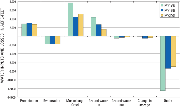
The complete water budget (table 2 and fig. 16) indicated that the major source of water to the lake is from surface-water inflow from Muskellunge Creek, which represented about 43 percent (MY1999) to 53 percent (MY2001) of the total water input to the lake. Ground water and precipitation each contributed between 19 and 30 percent of the total water input. During a dry year after an extended dry period (such as prior to MY1999), direct precipitation and ground water contribute almost as much water as Muskellunge Creek (about 40 percent from Muskellunge Creek and about 30 percent from both precipitation and ground water). The major loss of water from the lake is through the outlet (ranging from 76 percent of the total water loss in MY2001 to 84 percent MY1997). About 12 to 20 percent of the water lost from the lake is through evaporation, and about 3 to 4 percent is lost to the ground-water-flow system.
To help define where the phosphorus in Little St. Germain Lake originates and how much may be controllable, a detailed phosphorus budget was computed for each of the three monitoring years. Sources of phosphorus to the lake include precipitation, surface- and ground-water inflow, and contributions from septic systems. Phosphorus is removed from the lake through surface- and ground-water outflow and deposition to the lake sediments.
The phosphorus concentration in precipitation was assumed to be constant at 7 µg/L, a value suggested by Rose (1993) for northern Wisconsin. Therefore, direct precipitation contributed between about 52 lb (MY2001) and 58 lb (MY1999) of phosphorus to the lake during each study year (table 4).
[MY, monitoring year. Numbers may not add exactly to totals due to rounding.]
| Month | Precipitation | Muskellunge Creek | Ground- water input | Ground- water output | Septic systems | Outlet | Total input | Total output | Gain in lake |
|---|---|---|---|---|---|---|---|---|---|
| October 1, 1996, to September 30, 1997 (MY1997) | |||||||||
| Oct. | 5.8 | 50.1 | 72.0 | 2.7 | 7.4 | 65.0 | 135.3 | 67.7 | 67.6 |
| Nov. | 5.5 | 63.3 | 85.1 | 3.1 | 7.4 | 140.2 | 161.2 | 143.3 | 18.0 |
| Dec. | 3.6 | 75.2 | 66.7 | 3.0 | 7.4 | 149.7 | 152.9 | 152.8 | 0.2 |
| Jan. | 4.8 | 85.6 | 23.5 | 1.3 | 7.4 | 194.4 | 121.5 | 195.6 | -74.2 |
| Feb. | 1.5 | 69.6 | 73.4 | 4.6 | 7.4 | 162.8 | 151.9 | 167.5 | -15.5 |
| Mar. | 4.8 | 70.4 | 49.8 | 3.5 | 7.4 | 120.2 | 132.5 | 123.8 | 8.7 |
| Apr. | 1.1 | 108.4 | 109.4 | 8.3 | 7.4 | 60.6 | 226.3 | 68.9 | 157.4 |
| May | 4.6 | 181.8 | 99.9 | 8.1 | 7.4 | 146.0 | 293.8 | 154.1 | 139.7 |
| June | 5.7 | 211.9 | 71.4 | 6.1 | 7.4 | 127.9 | 296.4 | 134.0 | 162.4 |
| July | 7.2 | 221.6 | 49.2 | 2.6 | 7.4 | 82.1 | 285.3 | 84.6 | 200.7 |
| Aug. | 5.7 | 184.7 | 24.1 | 1.2 | 7.4 | 64.4 | 222.0 | 65.6 | 156.4 |
| Sept. | 3.8 | 151.3 | 17.7 | 0.9 | 7.4 | 55.3 | 180.2 | 56.3 | 123.9 |
| Total | 54.1 | 1,473.9 | 742.3 | 45.5 | 89.1 | 1,368.6 | 2,359.3 | 1,414.1 | 945.2 |
| December 1, 1998, to November 30, 1999 (MY 1999) | |||||||||
| Dec. | 1.9 | 42.9 | 38.9 | 1.7 | 7.4 | 53.5 | 91.1 | 55.1 | 36.0 |
| Jan. | 4.2 | 44.7 | 0.0 | 1.7 | 7.4 | 68.0 | 56.4 | 69.7 | -13.2 |
| Feb. | 2.7 | 38.4 | 66.8 | 2.9 | 7.4 | 47.0 | 115.3 | 49.9 | 65.4 |
| Mar. | 0.5 | 60.2 | 22.7 | 1.0 | 7.4 | 23.9 | 90.9 | 24.9 | 66.0 |
| Apr. | 2.6 | 80.0 | 42.1 | 1.8 | 7.4 | 26.0 | 132.2 | 27.8 | 104.3 |
| May | 15.0 | 130.3 | 79.2 | 3.3 | 7.4 | 33.2 | 232.0 | 36.5 | 195.4 |
| June | 6.0 | 79.4 | 39.3 | 1.7 | 7.4 | 36.4 | 132.1 | 38.1 | 94.0 |
| July | 11.1 | 75.3 | 61.2 | 1.9 | 7.4 | 30.9 | 155.1 | 32.8 | 122.3 |
| Aug. | 5.2 | 56.7 | 18.8 | 0.6 | 7.4 | 23.5 | 88.1 | 24.2 | 63.9 |
| Sept. | 3.8 | 33.0 | 19.4 | 0.7 | 7.4 | 22.2 | 63.7 | 22.9 | 40.7 |
| Oct. | 2.9 | 23.8 | 38.5 | 1.7 | 7.4 | 30.8 | 72.7 | 32.4 | 40.2 |
| Nov. | 1.9 | 29.6 | 33.0 | 1.4 | 7.4 | 47.2 | 71.9 | 48.6 | 23.3 |
| Total | 57.9 | 694.4 | 459.9 | 20.3 | 89.1 | 442.7 | 1,301.3 | 463.0 | 838.3 |
| November 1, 2000, to October 31, 2001 (MY 2001) | |||||||||
| Nov. | 2.9 | 23.9 | 28.4 | 1.2 | 7.4 | 77.7 | 62.6 | 78.9 | -16.3 |
| Dec. | 2.0 | 30.2 | 4.1 | 0.2 | 7.4 | 104.3 | 43.7 | 104.5 | -60.7 |
| Jan. | 1.9 | 36.4 | 84.6 | 3.6 | 7.4 | 52.0 | 130.2 | 55.7 | 74.6 |
| Feb. | 2.2 | 38.9 | 7.7 | 0.3 | 7.4 | 49.7 | 56.2 | 50.0 | 6.2 |
| Mar. | 1.0 | 47.4 | 68.7 | 3.0 | 7.4 | 31.7 | 124.6 | 34.6 | 90.0 |
| Apr. | 8.9 | 102.5 | 30.1 | 1.3 | 7.4 | 21.1 | 149.0 | 22.4 | 126.6 |
| May | 7.5 | 96.2 | 0.0 | 4.9 | 7.4 | 29.3 | 111.1 | 34.2 | 76.9 |
| June | 5.3 | 95.9 | 41.2 | 1.8 | 7.4 | 46.2 | 149.8 | 47.9 | 101.9 |
| July | 5.1 | 69.1 | 0.0 | 0.8 | 7.4 | 29.7 | 81.7 | 30.6 | 51.1 |
| Aug. | 3.0 | 62.0 | 4.0 | 0.1 | 7.4 | 28.1 | 76.4 | 28.3 | 48.1 |
| Sept. | 7.6 | 52.4 | 0.0 | 4.7 | 7.4 | 23.2 | 67.4 | 27.9 | 39.5 |
| Oct. | 4.1 | 50.8 | 34.2 | 1.5 | 7.4 | 24.0 | 96.5 | 25.5 | 71.0 |
| Total | 51.6 | 705.7 | 302.9 | 23.4 | 89.1 | 517.0 | 1,149.2 | 540.5 | 608.8 |
During each monitoring year, phosphorus concentrations were measured approximately monthly in Muskellunge Creek at Birchwood Drive (fig. 10). Daily concentrations for each monitoring year were obtained by linearly interpolating between each measurement. The amount of phosphorus delivered to the lake was then computed by multiplying the daily phosphorus concentrations by the daily inflow volumes. The total input of phosphorus from Muskellunge Creek was estimated to be about 1,470 lb (MY1997), 690 lb (1999), and 710 lb (2001) (table 4). About 50 percent of the phosphorus loading from surface-water inflow occurred between May and August. Because dissolved phosphorus represents about 50 percent of the total phosphorus at this site (throughout the year and during May through August), the total annual load of dissolved phosphorus ranged from about 350 lb (MY1999 and MY2001) to 750 lb (MY1997), of which about 175 lb (MY1999 and MY2001) to about 375 lb (MY1997) were delivered from May through August.
Dissolved phosphorus concentrations were measured twice in 13 of the 15 piezometers installed around the lake (fig. 2). Concentrations were not measured if the ground-water head gradient at a location was away from the lake (such as at piezometers 3 and 14). Ground-water simulations indicated that the gradient along most of the shoreline near piezometer 3 should be towards the lake; therefore, the concentration in piezometer 3 was assumed to be the average of that measured in piezometers 1 and 2. Ground water was leaving the lake at piezometer 14; therefore, a concentration was not measured. Phosphorus concentrations varied only slightly between measurements at each location. The median overall phosphorus concentration from all piezometers was 0.019 mg/L. All average concentrations were less than 0.035 mg/L, except in piezometers 4 (0.076 mg/L), 6 (0.303 mg/L), and 7 (0.386 mg/L) near No Fish Bay and the South Bay (fig. 2). Phosphorus input was then computed by multiplying the average phosphorus concentration in each piezometer by the monthly ground-water flux computed for each shoreline segment. The input of phosphorus from each shoreline segment is shown in figure 17 (for MY2001) by the thickness of the segment line. Most phosphorus enters the middle part of the lake represented by piezometers 6 and 7, where the phosphorus concentrations were highest. Ground water was estimated to contribute about 740 lb (MY1997), 460 lb (MY1999), and 300 lb (MY2001) of phosphorus during the various monitoring years (table 4).
The amount of phosphorus leaving the lake with ground-water outflow was estimated by multiplying the monthly ground-water outflow (table 2; proportioned between piezometers 5 and 14 based on the model output for MY1999) by the monthly average in-lake, near-surface phosphorus concentration estimated for the South and West Bays, respectively. Ground-water outflow was estimated to have removed about 46 lb (MY1997), 20 lb (MY1999), and 23 lb (MY2001) of phosphorus during the various monitoring years (table 4). About 80 percent of the phosphorus removed with ground-water outflow was from the South and Second South Bays.
The input of phosphorus from septic systems (M) was estimated by use of equation 2 (Reckhow and others, 1980):
M = ES * (Number of capita years) * (1 – SR) (2)
where M is a function of an export coefficient, ES, and a soil retention coefficient, SR. In applying equation 2, it was assumed that the most likely value for ES was 1.5 lb of phosphorus per capita per year and the most likely value for SR was 0.85. Typical export coefficients range from 1.1 lb per capita per year (Reckhow and others, 1980; Panuska and Kreider, 2002) to 1.8 lb per capita per year (Garn and others, 1996). The total number of capita years was estimated to be 330. This value was obtained on the basis of the assumptions that 300 of the 415 lake-front dwellings were in areas where ground water flowed toward the lake, 40 percent of these dwellings had 2 permanent residents (240 capita years), 30 percent of these dwellings had 3 residents living on the lake for 3 months (68 capita years), and 30 percent of these dwellings had 3 residents living on the lake for 1 month (22 capita years) (Ted Ritter, Little St. Germain Lake District, oral commun., 2004). This estimate includes all residents on the lake except those on the west part of the West Bay and the southern part of the Second South Bay where ground water was flowing away from the lake. The total input from septic systems was then computed to be 89 lb per year and was aassumed to be uniformly distributed throughout each year. This estimate is twice that estimated by Robertson and Rose (2000) because the ground-water-flow model indicated that much more of the lake had areas contributing ground water than previously estimated. By applying low and high estimates for ES (1.1 and 2.2 lb of phosphorus per capita per year, respectively) and SR (0.9 and 0.5, respectively), low and high estimates of phosphorus from septic systems were computed to be 36 and 363 lb, respectively.
The phosphorus leaving the lake's outlet was computed for each monitoring year by multiplying the daily outflow volumes by the measured or estimated daily concentrations. Estimated concentrations were obtained by linearly interpolating between the measurements in figure 10. The total amount of phosphorus in surface-water outflow was estimated to be about 1,370 lb (MY1997), 440 lb (MY1999), and 520 lb (MY2001) (table 4). The larger load in MY1997 than those estimated for the other two years was due to a combination of higher concentrations and higher flows than in the other two years. About 35 to 45 percent of the phosphorus load leaving the lake occurred between November and January when the lake was being drawn down.
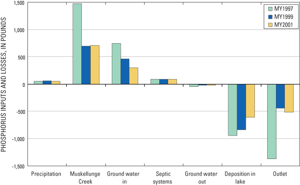
The total phosphorus input to the lake was about 2,360 lb in MY1997, 1,300 lb in MY1999, and 1,150 lb in MY2001 (table 4). The phosphorus budget (fig. 18) indicates that inflow from Muskellunge Creek was the major source of phosphorus to the lake (53 to 62 percent) and ground water was the secondary source (26 to 35 percent). Phosphorus from precipitation and septic systems each accounted for less than 8 percent of the total input. With the worst assumptions regarding input from septic systems, they would contribute between 14 percent (MY1997) to 26 percent (MY2001) of the total phosphorus input. Approximately 34 to 58 percent of the total phosphorus input to the lake (463 lb in MY1999 and 1,414 lb in MY1997) was exported out of the lake through Little St. Germain Creek. The remaining 32 to 66 percent of the phosphorus input (about 610 lb in MY2001 to 950 lb in MY1997) was deposited in the bed sediment of the lake. The overall phosphorus loading from MY1997 and MY1999 is very similar to that estimated by Robertson and Rose (2000). In the earlier study, the total phosphorus input in MY1997 was estimated to be 2,410 lb (compared to 2,360 lb in this study) and in MY1999 was estimated to be 1,310 lb (compared to 1,300 lb in this study). The primary differences in the phosphorus budgets were that phosphorus input from septic systems increased by about 45 lb and phosphorus input from ground water decreased by 93 and 52 lb, in MY1997 and MY1999, respectively, compared to the earlier study.
The total phosphorus input to the lake was estimated to be about 2,360 lb in MY1997, 1,300 lb in MY1999, and 1,150 lb in MY2001. Most of this phosphorus is input into the East and Upper East Bays and results in the water quality in these basins being poorer than other parts of the lake. One way to determine how much of the phosphorus loading to these basins would need to be reduced to improve their water quality is through the use of empirical models. These models relate phosphorus loading to measures describing lake-water quality (such as phosphorus and chlorophyll a concentrations and Secchi depth).
Several empirical models within the Wisconsin Lakes Modeling Suite (WiLMS; Panuska and Kreider, 2002) relate the hydrology and phosphorus loading to in-lake phosphorus concentrations. Four of these models were applicable to the East and Upper East Bay of Little St. Germain Lake (table 5). These two basins were modeled as a single lake because of the mixing between the two basins and their similar water quality. Therefore, the morphometry (based on data from table 1), hydrology (based on data from table 2), and phosphorus loading (based on data from table 4) to these basins for the three monitoring years and various phosphorus-reduction scenarios were input into these models within WiLMS and near-surface phosphorus concentrations and changes in their phosphorus concentrations were simulated. In computing the total phosphorus load to these two basins, loading from precipitation was computed for only the surface area of these two basins (46 percent of the total), loading from ground water was only the portion contributed to these basins, and the loading from septic systems were based on only 150 of the 300 dwellings contributing phosphorus to the lake. Therefore, the total loading for MY1997 was 2,031 lb, for MY1999 was 1,068 lb, and for MY2001 was 973 lb.
[All concentrations are in milligrams per liter; %, percent; MY, monitoring year; ft/yr, feet per year]
| MY1997 | |||||||
|---|---|---|---|---|---|---|---|
| Measured | Simulated tributary-load reductions | ||||||
| Base (0%) | 25% | 50% | 75% | 100% | |||
| Phosphorus loading (pounds) | 2,031 | 1,662 | 1,294 | 925 | 557 | ||
| Model | |||||||
| Walker, 1987 | 0.061 | 0.045 | 0.039 | 0.033 | 0.026 | 0.018 | |
| Canfield and Bachman, 1981 Natural Lakes | 0.061 | 0.049 | 0.042 | 0.034 | 0.026 | 0.017 | |
| Canfield and Bachman, 1981 Artificial Lakes | 0.061 | 0.042 | 0.036 | 0.030 | 0.024 | 0.016 | |
| Reckhow, 1977, Water load less than 164 ft/yr | 0.061 | 0.051 | 0.042 | 0.032 | 0.023 | 0.014 | |
| Average of models | 0.061 | 0.047 | 0.040 | 0.032 | 0.025 | 0.016 | |
| MY1999 | |||||||
| Measured | Simulated tributary-load reductions | ||||||
| Base (0%) | 25% | 50% | 75% | 100% | |||
| Phosphorus loading (pounds) | 1,068 | 894 | 720 | 547 | 373 | ||
| Model | |||||||
| Walker, 1987 | 0.041 | 0.039 | 0.035 | 0.030 | 0.025 | 0.019 | |
| Canfield and Bachman, 1981 Natural Lakes | 0.041 | 0.039 | 0.034 | 0.029 | 0.023 | 0.017 | |
| Canfield and Bachman, 1981 Artificial Lakes | 0.041 | 0.034 | 0.030 | 0.026 | 0.021 | 0.016 | |
| Reckhow, 1977, Water load less than 164 ft/yr | 0.041 | 0.036 | 0.030 | 0.024 | 0.018 | 0.013 | |
| Average of models | 0.041 | 0.037 | 0.032 | 0.027 | 0.022 | 0.016 | |
| MY2001 | |||||||
| Measured | Simulated tributary-load reductions | ||||||
| Base (0%) | 25% | 50% | 75% | 100% | |||
| Phosphorus loading (pounds) | 973 | 797 | 620 | 444 | 267 | ||
| Model | |||||||
| Walker, 1987 | 0.056 | 0.034 | 0.030 | 0.025 | 0.020 | 0.013 | |
| Canfield and Bachman, 1981 Natural Lakes | 0.056 | 0.034 | 0.029 | 0.024 | 0.018 | 0.012 | |
| Canfield and Bachman, 1981 Artificial Lakes | 0.056 | 0.030 | 0.026 | 0.022 | 0.017 | 0.012 | |
| Reckhow, 1977, Water load less than 164 ft/yr | 0.056 | 0.031 | 0.025 | 0.020 | 0.014 | 0.008 | |
| Average of models | 0.056 | 0.032 | 0.028 | 0.023 | 0.017 | 0.011 | |
| Average of three years | |||||||
| Measured | Simulated tributary-load reductions | ||||||
| Year | Base (0%) | 25% | 50% | 75% | 100% | ||
| 1997 | 0.061 | 0.047 | 0.040 | 0.032 | 0.025 | 0.016 | |
| 1999 | 0.041 | 0.037 | 0.032 | 0.027 | 0.022 | 0.016 | |
| 2001 | 0.056 | 0.032 | 0.028 | 0.023 | 0.017 | 0.011 | |
| Average of years | 0.053 | 0.039 | 0.033 | 0.027 | 0.021 | 0.015 | |
| Percent reduction | 14 | 29 | 45 | 62 | |||
| Predicted concentration with load reduction | 0.053 | 0.045 | 0.037 | 0.029 | 0.020 | ||
The models within WiLMS that were applied to the East and Upper East Bays use annual hydrologic and phosphorus loadings but simulate the water quality for the growing season (June through September); therefore, output from the model simulations was compared with the summer-average data for MY1997, MY1999, and MY2001 (table 5). Data were available for only the East Bay for MY1997 and MY1999; therefore, all comparisons including MY2001 were done with measured East Bay data only. There are no calibration factors in WiLMS; however, the output can be adjusted to account for model biases by only interpreting the results as a percentage change from some base condition.
The average phosphorus concentration predicted by the models for the three years was 0.039 mg/L, which is 26 percent lower than that measured in the East Bay (0.053 mg/L) (table 5). For MY1997, the average simulated concentration was 0.047 mg/L compared to 0.061 mg/L measured in the East Bay. For MY1999, the average simulated concentration was 0.037 mg/L compared to 0.041 mg/L measured in the East Bay. For MY2001, the average simulated concentration was 0.032 mg/L compared to 0.056 mg/L measured in the East Bay. The models consistently underestimated the phosphorus concentrations in the East Bay. This difference between simulated and measured concentrations may be the result of the release of phosphorus from the sediments of Little St. Germain Lake being higher than the sediment releases in the lakes that were used to develop the models used in WiLMS. The models were then applied with the data for various phosphorus-reduction scenarios: 25-, 50-, 75-, and 100-percent reduction in tributary loading from Muskellunge Creek; phosphorus contributions from all of the other sources were maintained at their present levels. The models predicted that these reductions in tributary loading would cause the average phosphorus concentration in these two basins to decrease 14 percent in response to a 25-percent reduction, by 29 percent in response to a 50-percent reduction, by 45 percent in response to a 75-percent reduction, and by 62 percent in response to a 100-percent reduction in tributary loading. If it is assumed that these percentages of change apply to the summer-average concentration measured in these bays, then a 25-percent reduction in tributary loading would result in a summer average concentration of 0.045 mg/L, a 50-percent decrease would result in 0.037 mg/L, a 75-percent reduction would result in 0.029 mg/L, and a 100-percent decrease in loading would result in 0.020 mg/L. Therefore, a 75- to 100-percent reduction in tributary loading would be needed for these parts of the lake to have a summer average phosphorus concentration of 0.024 mg/L and be classified as borderline mesotrophic/eutrophic.
Empirical relations have also been developed that predict summer average chlorophyll a concentrations and Secchi depths from near-surface phosphorus concentrations. Empirical relations developed for Wisconsin lakes by Lillie and others (1993) for nonstratified impoundments, also contained within WiLMS, were applied to determine how the various reductions in phosphorus loading from Muskellunge Creek (tributary loading) should affect near-surface, summer average chlorophyll a concentrations and Secchi depths in the East and Upper East Bays (table 6). These models predicted that with the measured summer average phosphorus concentration of 0.053 mg/L, the East and Upper East Bays should have a chlorophyll a concentration of 18.5 µg/L (compared to 25.8 µg/L measured in the East Bay for these three years) and a Secchi depth of 3.3 ft (compared to 4.3 ft measured). The predicted average summer phosphorus concentrations from table 5 were then input into the empirical relations. With a near-surface phosphorus concentration of 0.045 µg/L (based on a 25-percent reduction in tributary loading), the models predicted a chlorophyll a concentration of 16.5 µg/L (an 11-percent reduction from 18.5 µg/L predicted for 0.053 mg/L of phosphorus) and a Secchi depth of 3.28 ft (no change from that predicted for 0.053 mg/L of phosphorus)(table 6). With a near-surface phosphorus concentration of 0.020 mg/L (based on a 100-percent decrease in tributary loading), the models predicted a chlorophyll a concentration of 9.4 µg/L (a 49-percent decrease from that predicted for 0.053 mg/L of phosphorus) and a Secchi depth of 4.3 ft (a 30-percent increase from that predicted for 0.053 mg/L of phosphorus). If it is assumed that these percentages of change again apply to the average summer conditions measured in the East Bay, then a 25-percent reduction in tributary loading would result in a summer average chlorophyll a concentration of 23.0 µg/L and a summer average Secchi depth of 4.3 ft, a 50-percent reduction would result in a summer average chlorophyll a concentration of 20.1 µg/L and a summer average Secchi depth of 4.7 ft, a 75-percent reduction would result in a summer average chlorophyll a concentration of 16.9 µg/L and a summer average Secchi depth of 4.7 ft, and a 100-percent reduction would result in a summer average chlorophyll a concentration of 13.1 µg/L and a summer-average Secchi depth of 5.6 ft. Therefore, although phosphorus-load reductions would reduce phosphorus and chlorophyll a concentrations and increase water clarity, even with a 100-percent removal of phosphorus from Muskellunge Creek, the East and Upper East Bays would still be classified as eutrophic.
[%, percent; mg/L, milligrams per liter; µg/L, micrograms per liter]
| Tributary-load reduction | ||||||
|---|---|---|---|---|---|---|
| Constituent – summer average | Measured | Base (0%) | 25% | 50% | 75% | 100% |
| Simulated values | ||||||
| Total phosphorus (mg/L) | 0.053 | 0.053 | 0.045 | 0.037 | 0.029 | 0.020 |
| Chlorophyll a (µg/L) | 25.8 | 18.5 | 16.5 | 14.4 | 12.1 | 9.4 |
| Secchi depth (feet) | 4.3 | 3.3 | 3.3 | 3.6 | 3.6 | 4.3 |
| Percent reduction | ||||||
| Chlorophyll a | 0% | 11% | 22% | 35% | 49% | |
| Secchi depth | 0% | 0% | -10% | -10% | -30% | |
| Predicted response to tributary-load reduction (based on simulated percent reductions) |
||||||
| Total phosphorus (mg/L) | 0.053 | 0.053 | 0.045 | 0.037 | 0.029 | 0.020 |
| Chlorophyll a (µg/L) | 25.8 | 25.8 | 23.0 | 20.1 | 16.9 | 13.1 |
| Secchi depth (feet) | 4.3 | 4.3 | 4.3 | 4.7 | 4.7 | 5.6 |
Large reductions in phosphorus loading from Muskellunge Creek could have a significant effect on the water quality of not only the East and Upper East Bays, but also the South and Second South Bays because of the net flow of water through the lake. A reduction in phosphorus concentrations in these basins would also protect the water quality of the West Bay. However, because of the substantial contributions of phosphorus to the lake estimated from ground water, even with phosphorus loading from Muskellunge Creek completely eliminated, most of the lake would still be classified as borderline mesotrophic/eutrophic.
In the interest of protecting and improving the water quality of Little St. Germain Lake, the Little St. Germain Lake District initiated several cooperative studies with the U.S. Geological Survey between 1991 and 2004 to (1) document the water quality and the extent of winter anoxia in the lake, (2) evaluate the success of aerators at eliminating winter anoxia, (3) develop water and nutrient budgets for the lake, and (4) assess how the water quality of the lake should respond to changes in phosphorus loading.
Water quality in Little St. Germain Lake consistently varied among basins. The West Bay consistently had the greatest water clarity and lowest total phosphorus and chlorophyll a concentrations, the South Bay had intermediate clarity and intermediate phosphorus and chlorophyll a concentrations, and the East and Upper East Bays had the least water clarity and highest phosphorus and chlorophyll a concentrations. The summer average water quality in the lake was relatively stable from 1991 to 2000; however, water quality appears to have degraded since 2001. The West Bay has changed from oligotrophic to mesotrophic, the South Bay has changed from mesotrophic to eutrophic, and the East and Upper East Bays have changed from eutrophic to eutrophic/hypereutrophic.
Before aerators were installed and operated in the lake, winter anoxia frequently occurred throughout most of the lake, except in the West Bay and just below the ice in the East Bay. To eliminate winter anoxia, coarse-bubble line aerators were installed and operated in the Upper East, East, and South Bays. The aerator in the East Bay appeared to have little effect on dissolved oxygen concentrations throughout its basin. The ineffectiveness of the East Bay aerator may have been caused by the aerator being placed in water that was too shallow and (or) the aerator releasing too little air given the size of the East Bay. The aerators in the Upper East and South Bays were very successful at eliminating winter anoxia, and they maintained dissolved oxygen concentrations above 3.5 mg/L throughout almost the entire water column, except below the depth of the aerators.
Based on nitrogen-to-phosphorus ratios measured in the lake, the productivity in the lake is potentially limited by the supply of phosphorus. Detailed water and phosphorus budgets constructed for the lake indicated that the total phosphorus input to the lake was about 2,360 lb in monitoring year (MY)1997, 1,300 lb in MY1999, and 1,150 lb in MY2001. They also indicated that inflow from Muskellunge Creek was the major source of phosphorus to the lake (53 to 62 percent) and that ground water was the secondary source (26 to 35 percent). Precipitation and septic systems each accounted for less than 8 percent of the total phosphorus input. Results from a detailed ground-water-flow model indicated that ground water flows into the lake from all sides, except the south sides of West and Second South Bays. Simulated total ground-water inflow to the lake is about 13 percent higher than net inflow rather than 50 percent higher than net inflow as assumed in an earlier study by Robertson and Rose (2000). Therefore, compared to what was estimated in the earlier study, there was less ground-water input into the lake (and less phosphorus), but more input from septic systems. The net result was very little change in the phosphorus budget from the earlier study. Most of this phosphorus appears to come from natural sources—ground water and surface water flowing through relatively undeveloped areas surrounding Little St. Germain Lake and Muskellunge Lake.
Several empirical models within the Wisconsin Lakes Modeling Suite (WiLMS) were used to simulate how the water quality of East and Upper East Bays of the lake should respond to specific reductions in phosphorus loads from Muskellunge Creek. Simulation results indicated that large reductions in tributary loads could improve the water quality of the East and Upper East Bays. A 75- to 100-percent reduction in tributary loading would be needed for these parts of the lake to be classified as borderline mesotrophic/eutrophic. Improving the water quality of these bays would also improve the water quality of the South and Second South Bays because of the net flow of water through the lake. However, even with phosphorus loading from Muskellunge Creek completely eliminated, most of the lake would still be classified as borderline mesotrophic/eutrophic because of the contributions of phosphorus from ground water.
Barton, B.A., and Taylor, B.R., 1996, Oxygen requirements in northern Alberta Rivers with a general review of the adverse effects of low dissolved oxygen, Water Quality Research Journal of Canada, v. 31, no. 2, p. 361–409.
Canfield, D.E., and Bachmann, R.W., 1981, Prediction of total phosphorus concentrations, chlorophyll a, and Secchi depths in natural and artificial lakes: Canadian Journal of Fisheries Aquatic Sciences, v. 38, p. 414–423.
Carlson, R.E., 1977, A trophic state index for lakes: Limnology and Oceanography, v. 22, p. 361–369.
Corell, D.L., 1998, The role of phosphorus in the eutrophication of receiving waters–A review: Journal of Environmental Quality, v. 27, p. 261–266.
Garn, H.S., Olson, D.L., Seidel, T.L., and Rose, W.J., 1996, Hydrology and water quality of Lauderdale Lakes, Walworth County, Wisconsin, 1993–94: U.S. Geological Survey Water-Resources Investigations Report 96–4235, 29 p.
Graczyk, D.J., Hunt, R.J., Greb, S.R., Buchwald, C.A., and Krohelski, J.T., 2003, Hydrology, nutrient concentrations, and nutrient yields in nearshore areas of four lakes in northern Wisconsin, 1999–2001: U.S. Geological Survey Water-Resources Investigations Report 03–4144, 64 p.
Haitjema, H.M., 1995, Analytic element modeling of ground-water flow: San Diego, Calif., Academic Press, 394 p.
Hunt, R.J., Anderson, M.P., and Kelson, V.A., 1998, Improving a complex finite-difference ground water flow model through the use of an analytic element screening model: Ground Water, v. 36, no. 6., p. 1011–1017.
Hunt, R.J., Haitjema, H.M., Krohelski, J.T., and Feinstein, D.T., 2003, Simulating lake-ground water interactions—Approaches and insights: Ground Water, v. 41, no. 2, p. 227–237.
Lillesand, T., Chipman, J., Nagel, D., Reese, H., Bobo, M., and Goldman, R., 1998, Upper Midwest GAP analysis image processing protocol: Onalaska, Wis., U.S. Geological Survey, Environmental Management Technical Center, EMTC 98–G00, 25 p.
Lillie, R.A., Graham, Susan, and Rasmussen, Paul, 1993, Trophic state index equations and regional predictive equations for Wisconsin Lakes: Wisconsin Department of Natural Resources Management Findings, no. 35, 4 p.
Panuska, J.C., and Kreider, J.C., 2002, Wisconsin lake modeling suite program documentation and user's manual, Version 3.3 for Windows: Wisconsin Department of Natural Resources PUBL–WR–363–94, 32 p. [Available online through the Wisconsin Lakes Partnership: accessed December 29, 2004, at URL [http://www.dnr.state.wi.us/org/water/fhp/lakes/laketool.htm]
Patterson, G.L., 1989, Water resources of Vilas County, Wisconsin: Wisconsin Geological and Natural History Survey Miscellaneous Paper 89–1, 46 p.
Reckhow, K.H., 1977, Phosphorus models for lake management: Ph.D. dissertation, Harvard University, Cambridge, Massachusetts, Catalog No. 7731778, University Microfilms International, Ann Arbor, Michigan.
Reckhow, K.H., Beaulac, M.N., and Simpson, J.T., 1980, Modeling phosphorus loading in lake response under uncertainty: A manual and compilation of export coefficients: U.S. Environmental Protection Agency EPA–440/5–80–011.
Robertson, D.M., and Rose, W.J., 2000, Hydrology, water quality, and phosphorus loading of Little St. Germain Lake, Vilas County, Wisconsin: U.S. Geological Survey Water Resources Investigations Report 00–4209, 8 p.
Robertson, D.M., Rose, W.J., and Saad, D.A., 2003, Water quality and the effects of changes in phosphorus loading to Muskellunge Lake, Vilas County, Wisconsin: U.S. Geological Survey Water-Resources Investigations Report 03–4011, 18 p.
Rose, W.J., 1993, Water and phosphorus budgets and trophic state, Balsam Lake, northwestern Wisconsin, 1987–89: U.S. Geological Survey Water-Resources Investigations Report 91–4125, 28 p.
Shaw, Byron, Mechenich, Christine, and Klessig, Lowell, 1993, Understanding lake data: Madison, Wis., University of Wisconsin Extension Report G3582, 19 p.
Strack, O.D.L., 1989, Groundwater mechanics: Englewood Cliffs, N.J., Prentice-Hall, 732 p.
U.S. Geological Survey, Wisconsin District Lake-Studies Team, 2004, Water-quality and lake-stage data for Wisconsin lakes, water year 2003: U.S. Geological Survey Open-File Report 2004–1087, 158 p.
Walker, W.W., Jr., 1987, Empirical methods for predicting eutrophication in impoundments, Report no. 4, Phase III, Applications manual: U.S. Corps of Engineers Waterways Experimental Station Technical Report no. E–81–9, Vicksburg, Miss., 305 p.
Waschbusch, R.J., Olson, D.L., Ellefson, B.R., and Stark, P.A., 2002, Water-resources data, Wisconsin, water year 2001: U.S. Geological Survey Water-Data Report WI–01–1, 610 p.
Wentz, D.A., and Rose, W.J., 1991, Hydrology of Lakes Clara and Vandercook in north-central Wisconsin: U.S. Geological Survey Water-Resources Investigations Report 89–4204, 24 p.
Wetzel, R.G., 1983, Limnology, second edition, Saunders College Publishing, Philadelphia, Pa., 767 p.
Wisconsin Department of Natural Resources, 1985, Little St. Germain Lake, Vilas County, feasibility study results and management alternatives: Bureau of Water Resources Management, Lake Management Program, 22 p.
Wisconsin State Laboratory of Hygiene, Environmental Sciences Section, 1993, Manual of analytical methods, inorganic chemistry unit: Wisconsin State Laboratory of Hygiene, revised November 1993 [variously paged].
Document Accessibility: Adobe Systems Incorporated has information about PDFs and the visually impaired. This information provides tools to help make PDF files accessible. These tools convert Adobe PDF documents into HTML or ASCII text, which then can be read by a number of common screen-reading programs that synthesize text as audible speech. In addition, an accessible version of Acrobat Reader 6.0, which contains support for screen readers, is available. These tools and the accessible reader may be obtained free from Adobe at Adobe Access.
| AccessibilityFOIAPrivacyPolicies and Notices | |
 |
|