
Figure 2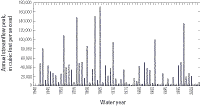
Annual peak streamflows measured from 1942 to 2003 for the gaging station on the Yuba River below Englebright Dam (YRE, 11418000) in the upper Yuba River watershed, California.
See table 1 for station name and location. Data source: http://nwis.waterdata.usgs.gov/, accessed November 8, 2004.
Figure 3A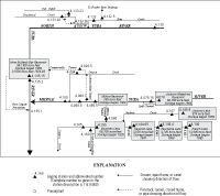
Stream diversions and reservoir storage in the upper Yuba River watershed, California.
Figure 3B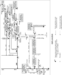
Stream diversions and reservoir storage in the upper Yuba River watershed, California.
Figure 4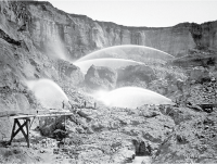
Hydraulic mining at Malakoff Diggings (circa 1876), located in the South Yuba River watershed, California.
Historic photograph taken by Carleton E. Watkins, Hearst Mining Collection, Bancroft Library, University of California at Berkeley.
Study Area
The Yuba River, a tributary to the Feather River in northern California, drains approximately 1,344 mi2 along the western slope of the Sierra Nevada (fig. 1). The study area is within the upper Yuba River watershed, which encompasses the area upstream of Englebright Lake and includes three tributaries: the North Yuba River, the Middle Yuba River, and the South Yuba River. A significant part of the Yuba River sediment load is deposited in New Bullards Bar Reservoir (Brown and Thorpe, 1947; Dendy and Champion, 1978), in Englebright Lake (Childs and others, 2003; Snyder and others, 2004b; Snyder and others, 2004c), and behind Log Cabin Dam and Our House Dam (Yuba County Water Agency, 1989). Because only wash-load-sized material (the finer part of the sediment load carried by streamflow) bypasses New Bullards Bar Reservoir on the North Yuba River, the focus of this study was on sediment transport solely within the Middle Yuba and South Yuba Rivers.
The upper Yuba River tributaries (North Yuba, Middle Yuba, and South Yuba Rivers) are steep, mountain drainages that flow through narrow, deeply incised canyons alternating between bedrock and alluvial reaches. Alluvial reaches store considerable volumes of sediment in the channel bed, active bars, and infrequent well-vegetated floodplains and terraces (Curtis and others, 2005). Bedrock reaches have minimal channel storage, although patchy alluvium may be found in deep pools or behind bedrock constrictions or large boulders. Large volumes of sediment, derived from upstream hydraulic-mining activities, are currently stored in several upland tributaries that flow into the Middle Yuba and South Yuba Rivers.
Climate, Precipitation, and Runoff
The study area has a mediterranean climate with hot, dry summers and cool, wet winters. Beginning in November, Pacific frontal systems bring winter precipitation into northern California, and approximately 85 percent of the annual precipitation falls between November and April. Mean annual precipitation ranges from 20 in. at Marysville at the western downstream end of the watershed (fig. 1) to more than 59 in. at the eastern margin of the watershed along the Sierra Nevada crest (Western Regional Climate Center, accessed November 8, 2004). Total precipitation at Englebright Lake was 24 in., 32 in., and 37 in. (California Data Exchange Center, accessed November 8, 2004) during water years 2001, 2002, and 2003, respectively. Average annual precipitation at Englebright Lake is 33 in.; therefore, water year 2001 was a dry year, 2002 was below average, and 2003 was above average.
Runoff in the study area is produced by winter storms from the Pacific, spring snowmelt, and occasional convective storms generated in the late summer or early autumn by subtropical air masses from the Gulf of Mexico (Kattleman, 1996). Peak flows can be as much as three orders of magnitude greater than base flows and annual runoff volumes can be as much as seven times greater in extremely wet years than those in critically dry years. Elevations between 4,000 to 6,000 ft in the study basin are susceptible to rain-on-snow events (California Department of Water Resources, 1966); these events have the greatest magnitude, duration, and ability to mobilize sediment. Notable runoff events (peak streamflows greater than 100,000 ft3/s) at the Yuba River below Englebright Dam (11418000) occurred during water years (WY) 1951, 1956, 1963, 1965, 1986, and 1997 (fig. 2). The timing of runoff throughout the study area is controlled to a considerable extent by a system of reservoirs and diversions (fig. 3).
Geologic Setting
Bedrock in the study area is composed primarily of Paleozoic metasediments and metavolcanics (ShooFly and Calaveras Formations), Paleozoic and Mesozoic plutonic rocks (Bowman Lake batholith, Sierra Nevada batholith, and Yuba River pluton), and a Mesozoic ophiolite (Smartville Complex). Ridge tops typically are capped by Eocene auriferous sediments deposited by the ancestral Yuba River, Miocene-Pliocene rhyolites, rhyolitic sediments (Valley Springs Formation), and andesitic lahars (Mehrten Formation) (Saucedo and Wagner, 1992).
Cenozoic geologic history includes uplift and tilting of the Sierra Nevada and at least two Late Quaternary glaciations (Lindgren, 1911; Bateman and Wahrhaftig, 1966; Christensen, 1966; James and others, 2002). Uplift and tilting reorganized drainage networks and initiated a period of sustained channel incision. The modern Yuba River system began incising approximately 5 Mya (million years ago) (Wakabayashi and Sawyer, 2001). The easternmost portion of the basin was glaciated during the Quaternary, and the Middle Yuba River and South Yuba River drainages are mantled by till and glacial outwash deposited by Late Quaternary valley glaciers (James and others, 2002).
Hydraulic Mining History
Gold-bearing sediments, deposited by the ancestral Yuba River (Whitney, 1880; Lindgren, 1911; Yeend, 1974), were hydraulically mined during the California Gold Rush of the mid-to-late 1800s and again during a protracted period of licensed mining in the early 1900s. Hydraulic-mining involved directing high-pressure water cannons at exposures of Eocene gravel (fig. 4) and washing the excavated sediment slurry through mercury-laden sluice boxes (Bowie, 1905; May, 1970; Averill, 1976; Alpers and others, 2005). Hydraulic mine tailings were conveyed into adjacent watercourses, leading to dramatic increases in sediment loads and severe aggradation (Hall, 1880; Turner, 1891; Gilbert, 1917). Gilbert (1917) estimated that hydraulic-mining contributed approximately 682 million yd3 of sediment to Yuba River channels. In 1884, owing to downstream environmental effects, large-scale hydraulic-mining was ended by court injunction (Sawyer Decision). Licensed hydraulic-mining began in 1893 (Camenetti Act) and continued in the Yuba River basin until the 1930s. Presently, the abandoned hydraulic mine pits experience chronic hillslope erosion (Yuan, 1979) and, therefore, are considered a significant sediment source to upper Yuba River channels (Curtis and others, 2005).
Extensive remobilization of stored hydraulic-mining sediment began as early as 1861 when severe winter storms delivered substantial volumes of sediment to the Central Valley. In 1941, the California Debris Commission built Englebright Dam to trap hydraulic-mining sediment mobilized within the upper Yuba River watershed. The majority of Middle Yuba River and South Yuba River mainstem channels have since recovered their pre-mining bed elevations, but significant volumes of hydraulic mining sediment remain stored in wide mainstem reaches and in smaller upland tributaries of these two rivers. Previous studies of the Yuba River and adjacent watersheds (Wildman, 1981; James, 1993; Curtis, 1999) indicate that these smaller tributaries are asymptotically incising toward pre-mining channel-bed elevations; therefore, remobilization of hydraulic-mining sediment continues to affect sediment yields from impacted basins.

