A Tectonic Model for the Spatial Occurrence of Porphyry Copper and
Polymetallic Vein Deposits—Applications to Central Europe
By Lawrence J. Drew
Abstract
A structural-tectonic model, which was developed
to assess the occurrence of undiscovered porphyry copper deposits
and associated polymetallic vein systems for the Mátra Mountains,
Hungary, has been expanded here and applied to other parts of central
Europe. The model explains how granitoid stocks are emplaced and
hydrothermal fluids flow within local strain features (duplexes)
within strike-slip fault systems that develop in continental crust
above subducting plates. Areas of extension that lack shear at the
corners and along the edges of the fault duplexes are structural
traps for the granitoid stocks associated with porphyry copper deposits.
By contrast, polymetallic vein deposits are emplaced where shear
and extension are prevalent in the interior of the duplexes. This
model was applied to the Late Cretaceous-age porphyry copper and
polymetallic vein deposits in the Banat-Timok-Srednogorie region
of Romania-Serbia-Bulgaria and the middle Miocene-age deposits in
Romania and Slovakia. In the first area, porphyry copper deposits
are most commonly located at the corners, and occasionally along
the edges, of strike-slip fault duplexes, and the few polymetallic
vein deposits identified are located at interior sites of the duplexes.
In the second area, the model accounts for the preferred sites of
porphyry copper and polymetallic vein deposits in the Apuseni Mountains
(Romania) and central Slovakian volcanic field (Slovakia).
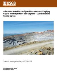
On the cover: View of the
Assarel porphyry copper deposit, the largest open-pit mine in
Bulgaria. Production is more than 10 million metric tons per
year of ore, from which 180,000 metric tons of copper concentrate
is extracted (0.45 percent copper, 2.5 grams per metric ton gold).
The mine is located in the Panagyurishte area, which is within
the central Srednogorie region of central Bulgaria. The snow-covered
Stara Planina Mountains in the background are seen 40 kilometers
to the south. This area is famous for the discovery in the 1950s
of a fabulous gold treasure dating to 2,500 B.C., and the region
has a rich mining history since before Thracian time. The mine
is located near the headwaters of the Luda Yana River, which
flows into the Maritsa River, which then flows southward across
Bulgaria and Greece, into the Aegean Sea. Photograph by Lawrence
J. Drew.
Recommended download procedures due to large
file size—right-click (PC) or control-click (Macintosh)
and save file to hard drive. Opening file from hard drive will
result in a faster load time.
Contact
For scientific questions or comments, please send inquiries to Lawrence
J. Drew (E-mail address: ldrew@usgs.gov).
For more information about the
USGS and its products:
Telephone: 1-888-ASK-USGS
World Wide Web: http://www.usgs.gov/
Any use of trade, product, or firm names is for descriptive
purposes only and does not imply endorsement by the U.S. Government. Although
this report is in the public domain, permission must be secured from the
individual copyright owners to reproduce any copyrighted materials contained
within this report.
Download the latest version of Adobe
Reader, free of charge.