KAHO_BenthicHabitats

Metadata also available as

Metadata:


Identification_Information:
Citation:
Citation_Information:
Originator: Ann E. Gibbs
Publication_Date: 2007
Title: KAHO_BenthicHabitats
Geospatial_Data_Presentation_Form: vector digital data
Series_Information:
Series_Name: Scientific Investigations Report
Issue_Identification: 2006-5256
Publication_Information:
Publication_Place: Santa Cruz, CA
Publisher:
U.S. Department of Interior, U.S. Geological Survey, Western Region Coastal and Marine Geology
Online_Linkage: <http://pubs.usgs.gov/sir/2006/5256/>
Description:
Abstract:
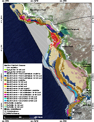
A benthic habitat polygon coverage has been created of the coral reef ecosystem within and adjacent to Kaloko-Honokohau National Historical Park (KAHO) on the Kona Coast of Hawai'i. Polygons were hand-digitized from visual interpretation of aerial photography and SHOALS bathymetry data. We also utilized in situ knowledge from towed instruments, underwater photography and videography, and diver and snorkeler observations. The polygons have attributes for Main Structure/Substrate, Dominant Structure/Substrate, Major Biological Cover, Percent of Major Biological Cover, Reef Zone, Unique ID, and measurements of Area (m2) of each polygon.
Purpose:
This mapping effort was carried out as a part of a USGS effort to understand geologic processes of coral reef systems in the U.S. and its trust territorities. It is intended to provide a baseline inventory of benthic habitat resources of the coral reef system within and adjacent to Kaloko-Honokohau National Historical Park (KAHO) on the Kona Coast of Hawai'i for use by scientists, managers, and the general public. The data can be used with geographic information systems (GIS) software for research purposes.
Supplemental_Information:
Additional information about the field activities from which these data were derived are available online at <http://walrus.wr.usgs.gov/infobank/a/a803hw/html/a-8-03-hw.meta.html>, <http://walrus.wr.usgs.gov/infobank/a/a204hw/html/a-2-04-hw.meta.html> and <http://walrus.wr.usgs.gov/infobank/a/a604hw/html/a-6-04-hw.meta.html>.

Any use of trade, product, or firm names is for descriptive purposes only and does not imply endorsement by the U.S. Government.

Although this Federal Geographic Data Committee-compliant metadata file is intended to document the data set in nonproprietary form, as well as in ESRI format, this metadata file may include some ESRI-specific terminology.

Time_Period_of_Content:
Time_Period_Information:
Single_Date/Time:
Calendar_Date: 2006 January 31
Currentness_Reference: publication date
Status:
Progress: Complete
Maintenance_and_Update_Frequency: None planned
Spatial_Domain:
Bounding_Coordinates:
West_Bounding_Coordinate: -156.048877
East_Bounding_Coordinate: -156.025709
North_Bounding_Coordinate: 19.696424
South_Bounding_Coordinate: 19.663352
Keywords:
Theme:
Theme_Keyword_Thesaurus:
Global Change Master Directory (GCMD) <http://gcmd.gsfc.nasa.gov/Data/portals/gcmd/param_search/OCEANS.html>
Theme_Keyword: coral reefs
Theme:
Theme_Keyword_Thesaurus:
Global Change Master Directory (GCMD) <http://gcmd.gsfc.nasa.gov/Data/portals/gcmd/param_search/BIOSPHERE.html>
Theme_Keyword: benthic habitat
Theme:
Theme_Keyword_Thesaurus:
ISO 19115 Topic Category <http://gcmd.gsfc.nasa.gov/User/difguide/iso_topics.html>
Theme_Keyword: biota
Theme_Keyword: boundaries
Theme_Keyword: geoscientificinformation
Theme_Keyword: imageryBaseMapsEarthCover
Theme_Keyword: oceans
Place:
Place_Keyword_Thesaurus:
Geographic Names Information System (GNIS) <http://geonames.usgs.gov/pls/gnis/web_query.gnis_web_query_form>
Place_Keyword: Hawai'i
Place_Keyword: Kaloko-Honokohau National Historical Park
Place_Keyword: Honokohau Bay
Place_Keyword: Honokohau Harbor
Place_Keyword: Kaloko
Place_Keyword: Honokohau
Access_Constraints: None
Use_Constraints:
Please recognize the U.S. Geological Survey (USGS) as the source of this information.

Although these data have been used by the U.S. Geological Survey, U.S. Department of the Interior, no warranty expressed or implied is made by the U.S. Geological Survey as to the accuracy of the data.

The act of distribution shall not constitute any such warranty, and no responsibility is assumed by the U.S. Geological Survey in the use of this data, software, or related materials.

These data are not suitable for navigation.

Point_of_Contact:
Contact_Information:
Contact_Organization_Primary:
Contact_Organization: USGS Pacific Science Center
Contact_Person: Ann E. GIbbs
Contact_Position: Coastal and Marine Geology (CMG)
Contact_Address:
Address_Type: mailing and physical address
Address: 400 Natural Bridges Dr.
City: Santa Cruz
State_or_Province: CA
Postal_Code: 95060
Country: USA
Contact_Voice_Telephone: 831-427-4740
Contact_Facsimile_Telephone: 831-427-4748
Contact_Electronic_Mail_Address: agibbs@usgs.gov
Browse_Graphic:
Browse_Graphic_File_Name: <http://pubs.usgs.gov/sir/2006/5256/images/KAHO_BenthicHabitats.gif>
Browse_Graphic_File_Description: gif image of habitat polygons
Browse_Graphic_File_Type: GIF
Data_Set_Credit:
Thanks to Pat Chavez and his group from the USGS in Flagstaff for coordinating our acquisition of the SHOALS bathymetric data. The National Park Service provided the aerial photography. Josh Logan (USGS Santa Cruz) created the SHOALS image used as a base layer. His help in field operations and his GIS advice were invaluable throughout the entire process. Paul Jokiel, Ku'ulei Rodgers, Will Smith and others from the University of Hawai'i assisted with field observations and accuracy assessments. A special mahalo goes to Captain Joe Reich, owner of the Alyce C on Moloka'i, whose exceptional navigation and expertise were critical to the success of this project. This work was carried out under the leadership of Project Chief Mike Field (USGS Santa Cruz) as part of a larger Geologic Resource Evaluation for the Kona Coast National Parks.
Native_Data_Set_Environment:
Microsoft Windows XP Version 5.1 (Build 2600) Service Pack 2; ESRI ArcCatalog 9.1.0.722
Cross_Reference:
Citation_Information:
Originator: Ann E. Gibbs
Publication_Date: 2007
Title:
Shape file KAHO_benthichabitats -- Benthic habitat polygons for the coral reef ecosystem of Kaloko-Honokohau (KAHO) National Historical Park, Hawai'i
Online_Linkage: <http://pubs.usgs.gov/sir/2006/5256>

Data_Quality_Information:
Attribute_Accuracy:
Attribute_Accuracy_Report:
Vector polygon boundaries were delineated by interpretation of georeferenced color aerial photography and SHOALS bathymetry data. The polygons were attributed using a modified version of the NOS/NOAA coral reef habitat digitizing extension for ESRI ArcView <http://biogeo.nos.noaa.gov/products/apps/digitizer>. Attributes are generated directly in the shapefile and errors are not expected. The shapefiles are free of topology errors. Overall accuracy of the major habitat classifications in these data is greater than 90.27%.
Logical_Consistency_Report:
Digitizing was conducted using the "heads up" on screen method. Delineation of habitat boundaries is from interpretation of georeferenced aerial photography, SHOALS bathymetry data, and in situ observations . The digital imagery this interpretation is based on are believed to be logically consistent, although not tested.
Completeness_Report:
Data are complete. Habitat boundaries are based on interpretation of digital imagery data of ground conditions at the time the imagery was collected. Polygon boundaries are subject to change over time.
Lineage:
Source_Information:
Source_Citation:
Citation_Information:
Originator: NOAA Biogeography Team
Publication_Date: 2005
Title:
Benthic Habitats of the U.S. Pacific Territories Classification Scheme
Geospatial_Data_Presentation_Form: document
Publication_Information:
Publication_Place: Silver Spring, Maryland
Publisher: NOAA\NOS\Biogeography Program
Online_Linkage: <http://biogeo.nos.noaa.gov/products/us_pac_terr/htm/descrip.htm>
Larger_Work_Citation:
Citation_Information:
Originator: NOAA Biogeography Team
Publication_Date: 2005
Title: Benthic Habitats of the U.S. Pacific Territories
Geospatial_Data_Presentation_Form: document
Publication_Information:
Publication_Place: Silver Spring, Maryland
Publisher: NOAA/NOS/Biogeography Team
Online_Linkage: <http://biogeo.nos.noaa.gov/products/us_pac_terr/>
Type_of_Source_Media: online
Source_Time_Period_of_Content:
Time_Period_Information:
Single_Date/Time:
Calendar_Date: 2006
Source_Currentness_Reference: publication date
Source_Citation_Abbreviation:
Classification Scheme for Benthic Habitats: U.S. Pacific Territories
Source_Contribution:
Describes the polygon attributes used in the classification scheme
Source_Information:
Source_Citation:
Citation_Information:
Originator: Ken Buja
Publication_Date: Unknown
Title: Coral Reef Digitizing Extension
Edition: 3.0.3
Geospatial_Data_Presentation_Form: map
Publication_Information:
Publication_Place: Silver Spring, Maryland
Publisher: National Ocean Service
Online_Linkage: <http://biogeo.nos.noaa.gov/products/apps/digitizer>
Type_of_Source_Media: Software
Source_Time_Period_of_Content:
Time_Period_Information:
Range_of_Dates/Times:
Beginning_Date: 2002
Ending_Date: 2002
Source_Currentness_Reference: Version 3.0.3
Source_Citation_Abbreviation: Coral reef habitat digitizing extension for ArcView 3.2
Source_Contribution:
This ArcView extension was used to digitize GIS coral reef habitat and zone polygons
Source_Information:
Source_Citation:
Citation_Information:
Originator: Coyne, M.S.
Originator: Monaco, M.E.
Originator: Anderson, M.
Originator: Smith, W.
Originator: Jokiel, P.
Originator: Battista, T.A.
Originator: Waddell, J.
Originator: Kendall, M.S.
Publication_Date: 2003
Title: Benthic Habitats of the Main Eight Hawaiian Islands
Publication_Information:
Publication_Place: Silver Spring, Maryland
Publisher: NOAA/NOS/Biogeography Team
Online_Linkage: <http://biogeo.nos.noaa.gov/products/hawaii_cd/htm/molokaifl.htm>
Source_Scale_Denominator: 24000
Type_of_Source_Media: online
Source_Time_Period_of_Content:
Time_Period_Information:
Single_Date/Time:
Calendar_Date: 2003
Source_Currentness_Reference: Final Report
Source_Citation_Abbreviation: Color Aerial Photography
Source_Contribution:
Aerial mosaics were used as a base layer for benthic habitat interpretation
Source_Information:
Source_Citation:
Citation_Information:
Originator: USGS Western Region Coral Reef Project
Publication_Date: Unpublished Material
Title: Underwater digital video
Type_of_Source_Media: digital videotape
Source_Time_Period_of_Content:
Time_Period_Information:
Range_of_Dates/Times:
Beginning_Date: 2003
Ending_Date: 2004
Source_Currentness_Reference: ground condition
Source_Citation_Abbreviation: Underwater digital video
Source_Contribution: Used to help determine benthic habitat type
Source_Information:
Source_Citation:
Citation_Information:
Originator: USGS Western Region Coral Reef Project
Publication_Date: Unpublished Material
Title: Underwater still photographs
Type_of_Source_Media: CD-ROM
Source_Time_Period_of_Content:
Time_Period_Information:
Range_of_Dates/Times:
Beginning_Date: 2003
Ending_Date: 2004
Source_Currentness_Reference: ground condition
Source_Citation_Abbreviation: Underwater still photographs
Source_Contribution: Used to help determine benthic habitat type
Source_Information:
Source_Citation:
Citation_Information:
Originator: U.S. Army Corps of Engineers
Publication_Date: 2000
Title: SHOALS lidar bathymetry data for the Big Island of Hawai'i
Geospatial_Data_Presentation_Form: xyz data
Publication_Information:
Publication_Place: Mobile, Alabama
Publisher: U.S. Army Corps of Engineers
Online_Linkage: <http://shoals.sam.usace.army.mil/Hawaii/pages/Hawaii.htm>
Type_of_Source_Media: online
Source_Time_Period_of_Content:
Time_Period_Information:
Multiple_Dates/Times:
Single_Date/Time:
Calendar_Date: 1999
Single_Date/Time:
Calendar_Date: 2000
Source_Currentness_Reference: ground condition
Source_Citation_Abbreviation: SHOALS bathymetry data
Source_Contribution: Used as a base layer for interpretation of benthic habitats
Process_Step:
Process_Description:
Orthorectified mosaicked color aerial photographs and gridded SHOALS bathymetry data in geotif format were used for the interpretation. These were loaded into ArcView 3.2 GIS software along with the NOAA Coral Reef Habitat Digitizing extension. Additional field data used for the interpretation include underwater digital video and photographs, plus diver observations. Habitat boundaries were delineated directly into the digitally referenced GIS. Polygons were saved as a shapefile.
Source_Used_Citation_Abbreviation: Digitizing Process
Process_Date: 2003-2005
Source_Produced_Citation_Abbreviation: Kaloko-Honokohau (KAHO) Benthic Habitat Map
Process_Contact:
Contact_Information:
Contact_Person_Primary:
Contact_Person: Ann E. Gibbs
Contact_Organization: USGS Pacific Science Center
Contact_Position: Geologist
Contact_Address:
Address_Type: mailing and physical address
Address: 400 Natural Bridges Dr.
City: Santa Cruz
State_or_Province: CA
Postal_Code: 95060
Country: USA
Contact_Voice_Telephone: (831) 427-4740
Contact_Facsimile_Telephone: (831) 427-4748
Contact_Electronic_Mail_Address: agibbs@usgs.gov
Hours_of_Service: 8:00 AM to 5:00 PM M-F PST
Process_Step:
Process_Description:
GIS topologic quality was established using ArcView extension routines that check for: Overlapping polygons Multipart polygons Sliver polygons Void polygons and Adjacency
Source_Used_Citation_Abbreviation: Quality control
Process_Date: 2004
Source_Produced_Citation_Abbreviation: Kaloko-Honokohau (KAHO) Benthic Habitat Map
Process_Contact:
Contact_Information:
Contact_Person_Primary:
Contact_Person: Ann E. Gibbs
Contact_Organization: USGS Pacific Science Center
Contact_Position: Geologist
Contact_Address:
Address_Type: mailing and physical address
Address: 400 Natural Bridges Dr.
City: Santa Cruz
State_or_Province: CA
Postal_Code: 95060
Country: USA
Contact_Voice_Telephone: (831) 427-4740
Contact_Facsimile_Telephone: (831) 427-4748
Contact_Electronic_Mail_Address: agibbs@usgs.gov
Hours_of_Service: 8:00 AM to 5:00 PM M-F PST

Spatial_Data_Organization_Information:
Direct_Spatial_Reference_Method: Vector
Point_and_Vector_Object_Information:
SDTS_Terms_Description:
SDTS_Point_and_Vector_Object_Type: G-polygon
Point_and_Vector_Object_Count: 451

Spatial_Reference_Information:
Horizontal_Coordinate_System_Definition:
Planar:
Grid_Coordinate_System:
Grid_Coordinate_System_Name: Universal Transverse Mercator
Universal_Transverse_Mercator:
UTM_Zone_Number: 5
Transverse_Mercator:
Scale_Factor_at_Central_Meridian: 0.999600
Longitude_of_Central_Meridian: -153.000000
Latitude_of_Projection_Origin: 0.000000
False_Easting: 500000.000000
False_Northing: 0.000000
Planar_Coordinate_Information:
Planar_Coordinate_Encoding_Method: coordinate pair
Coordinate_Representation:
Abscissa_Resolution: 0.000008
Ordinate_Resolution: 0.000008
Planar_Distance_Units: meters
Geodetic_Model:
Horizontal_Datum_Name: North American Datum of 1983
Ellipsoid_Name: Geodetic Reference System 80
Semi-major_Axis: 6378137.000000
Denominator_of_Flattening_Ratio: 298.257222

Entity_and_Attribute_Information:
Detailed_Description:
Entity_Type:
Entity_Type_Label: KAHO_BenthicHabitats
Entity_Type_Definition: Shapefile attribute table
Entity_Type_Definition_Source: None
Attribute:
Attribute_Label: FID
Attribute_Definition: Internal feature number.
Attribute_Definition_Source: ESRI
Attribute_Domain_Values:
Unrepresentable_Domain:
Sequential unique whole numbers that are automatically generated.
Attribute:
Attribute_Label: Shape
Attribute_Definition: Feature geometry.
Attribute_Definition_Source: ESRI
Attribute_Domain_Values:
Unrepresentable_Domain: Coordinates defining the features.
Attribute:
Attribute_Label: ID
Attribute_Definition: Feature number
Attribute_Definition_Source: Habitat classification scheme
Attribute_Domain_Values:
Codeset_Domain:
Codeset_Name: ID
Codeset_Source: Habitat digitizing extension
Attribute:
Attribute_Label: UNIQUEID
Attribute_Definition: Unique 4-digit ID used to describe polygon
Attribute_Definition_Source: Habitat classification scheme
Attribute_Domain_Values:
Codeset_Domain:
Codeset_Name: UNIQUEID
Codeset_Source: Habitat digitizing extension
Attribute:
Attribute_Label: M_STRUCT
Attribute_Definition: Main structure/substrate
Attribute_Definition_Source: Habitat classification scheme
Attribute_Domain_Values:
Codeset_Domain:
Codeset_Name: M_STRUCT
Codeset_Source: Habitat digitizing extension
Attribute:
Attribute_Label: D_STRUCT
Attribute_Definition: Dominant structure/substrate
Attribute_Definition_Source: Habitat classification scheme
Attribute_Domain_Values:
Codeset_Domain:
Codeset_Name: D_STRUCT
Codeset_Source: Habitat digitizing extension
Attribute:
Attribute_Label: M_COVER
Attribute_Definition: Major biological cover
Attribute_Definition_Source: Habitat classification scheme
Attribute_Domain_Values:
Codeset_Domain:
Codeset_Name: M_COVER
Codeset_Source: Habitat digitizing extension
Attribute:
Attribute_Label: P_COVER
Attribute_Definition: Percent of major biological cover
Attribute_Definition_Source: Habitat classification scheme
Attribute_Domain_Values:
Codeset_Domain:
Codeset_Name: P_COVER
Codeset_Source: Habitat digitizing extension
Attribute:
Attribute_Label: ZONE
Attribute_Definition: Name of cross-shelf geographic zone for each GIS polygon
Attribute_Definition_Source: Habitat classification scheme
Attribute_Domain_Values:
Codeset_Domain:
Codeset_Name: ZONE
Codeset_Source: Habitat digitizing extension
Attribute:
Attribute_Label: AREA
Attribute_Definition: Area of polygon
Attribute_Definition_Source: ESRI
Overview_Description:
Entity_and_Attribute_Overview:
Attributes are modified from NOAA/NOS/Biogeography Team's Benthic Habitat Mapping of the U.S. Pacific Territories available online at <http://biogeo.nos.noaa.gov/products/us_pac_terr/>
Entity_and_Attribute_Detail_Citation:
NOAA National Centers for Coastal Ocean Science (NCCOS). 2005. Shallow-Water Benthic Habitats of American Samoa, Guam, and the Commonwealth of the Northern Mariana Islands (CD-ROM). NOAA Technical Memorandum NOS NCCOS 8, Biogeography Team. Silver Spring, MD.

Distribution_Information:
Distributor:
Contact_Information:
Contact_Organization_Primary:
Contact_Organization: USGS Pacific Science Center
Contact_Person: Ann E. Gibbs
Contact_Address:
Address_Type: mailing and physical address
Address: 400 Natural Bridges Dr.
City: Santa Cruz
State_or_Province: CA
Postal_Code: 95060
Country: U.S.A.
Contact_Voice_Telephone: 831-427-4740
Contact_Facsimile_Telephone: 831-427-4748
Contact_Electronic_Mail_Address: agibbs@usgs.gov
Resource_Description: Downloadable Data
Distribution_Liability:
Please recognize the U.S. Geological Survey (USGS) as the source of this information.

Although these data have been used by the U.S. Geological Survey, U.S. Department of the Interior, no warranty expressed or implied is made by the U.S. Geological Survey as to the accuracy of the data.

Any use of trade, product, or firm names is for deescriptive purposes only and does not imply endorsement by the U.S. Government.

The act of distribution shall not constitute any such warranty, and no responsibility is assumed by the U.S. Geological Survey in the use of this data, software, or related materials.

These data are not suitable for navigation.

Standard_Order_Process:
Digital_Form:
Digital_Transfer_Information:
Format_Name: ARCG
Transfer_Size: 6.640
Digital_Transfer_Option:
Online_Option:
Computer_Contact_Information:
Network_Address:
Network_Resource_Name: <http://pubs.usgs.gov/of/2006/5256/>
Fees: None

Metadata_Reference_Information:
Metadata_Date: 20070521
Metadata_Contact:
Contact_Information:
Contact_Organization_Primary:
Contact_Organization: USGS Pacific Science Center
Contact_Person: Ann E. Gibbs
Contact_Position: Coastal and Marine Geology
Contact_Address:
Address_Type: mailing and physical address
Address: 400 Natural Bridges Dr.
City: Santa Cruz
State_or_Province: CA
Postal_Code: 95060
Country: USA
Contact_Voice_Telephone: 831-427-4740
Contact_Facsimile_Telephone: 831-427-4748
Contact_Electronic_Mail_Address: agibbs@usgs.gov
Metadata_Standard_Name: FGDC Content Standards for Digital Geospatial Metadata
Metadata_Standard_Version: FGDC-STD-001-1998
Metadata_Time_Convention: local time
Metadata_Extensions:
Online_Linkage: <http://www.esri.com/metadata/esriprof80.html>
Profile_Name: ESRI Metadata Profile

Generated by mp version 2.8.6 on Mon May 21 14:49:20 2007