Geographic Analysis and Monitoring Program
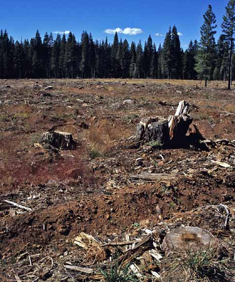
Photograph of a recently clear-cut area in Plumas National Forest, Plumas County, Calif.
The U.S. Geological Survey has developed and is implementing the Land Cover Trends project to estimate and describe the temporal and spatial distribution and variability of contemporary land-use and land-cover change in the United States. As part of the Land Cover Trends project, the purpose of this study was to assess land-use/land-cover change in the Sierra Nevada ecoregion for the period 1973 to 2000 using a probability sampling technique and satellite imagery. We randomly selected 36 100-km2 sample blocks to derive thematic images of land-use/land-cover for five dates of Landsat imagery (1973, 1980, 1986, 1992, 2000). We visually interpreted as many as 11 land-use/land-cover classes using a 60-meter minimum mapping unit from the five dates of imagery yielding four periods for analysis. Change-detection results from post-classification comparison of our mapped data showed that landscape disturbance from fire was the dominant change from 1973-2000. The second most-common change was forest disturbance resulting from harvest of timber resources by way of clear-cutting. The rates of forest regeneration from temporary fire and harvest disturbances coincided with the rates of disturbance from the previous period. Relatively minor landscape changes were caused by new development and reservoir drawdown. Multiple linear regression analysis suggests that land ownership and the proportion of forest and developed cover types were significant determinants of the likelihood of direct human-induced change occurring in sampling units. Driving forces of change include land ownership, land management such as fire suppression policy, and demand for natural resources.
Download this report as a 34-page PDF file (sir2007-5011.pdf; 10.9 MB)
For questions about the content of this report, contact Christian Raumann (christian_raumann@urscorp.com) or Chris Soulard (csoulard@usgs.gov).
Suggested citation and version history
Download a free copy of the latest version of Adobe Reader.
|
Help |
PDF help |
Publications main page |
| Western Scientific Investigations Reports |
| Geography | Geographic Analysis and Monitoring Program
|

![]() U.S. Department of the Interior | U.S. Geological Survey
U.S. Department of the Interior | U.S. Geological Survey
URL: https://pubs.usgs.gov/sir/2007/5011/
Page Contact Information: Michael Diggles
Page Created: February 22, 2007
Page Last Modified: December 24, 2009