Scientific Investigations Report 2007-5139
National Water-Quality Assessment Program:
Transport of Anthropogenic and Natural Contaminants (TANC) to Public-Supply Wells
 |
Select an option: |
|
CONTENTS Abstract Introduction Purpose and Scope Description of Study Area Previous Studies Acknowledgments Methods Design of Monitoring Well Network Drilling, Coring, and Well Installation Collection and Analysis of Water Samples Age Dating of Ground Water Tritium and Tritiogenic Helium-3 Sulfur Hexafluoride Quality Assurance Lithology, Mineralogy, and Elemental Analysis of Core Material Hydrogeologic Setting Lithology and Mineralogy of the Hydrogeologic Units Estimation of Aquifer Properties Ground-Water Flow Patterns Ground-Water Chemistry Chemical Composition and Mineral Saturation Indexes Dissolved Organic Carbon and Dissolved Solids Concentrations Redox Conditions Stable Isotopes of Water Ground-Water Age and Age Distributions Apparent Sulfur Hexafluoride and Tritium/Helium-3 Ground-Water Ages Assessing Ground-Water Age Distributions Using Lumped Parameter Models Occurrence of Anthropogenic and Naturally Occurring Contaminants in Ground-Water Samples Nitrate-N Concentrations and Isotopes and Dissolved Gases Volatile Organic Compounds Pesticides Sulfur Species and Hydrogen Sulfide Radon-222 and Uranium Arsenic Concentrations and Speciation Temporal Variability in Water Chemistry from Surficial Aquifer System Wells and the Public-Supply Well Sources and Mixing of Water in the Public-Supply Well Chemical Variations with Depth during Ambient and Pumping Conditions Estimating Mixing Proportions of Water Using Geochemical Mass-Balance Modeling Movement of Contaminants to the Public-Supply Well Summary Selected References |
In 2001, the National Water-Quality Assessment (NAWQA) Program of the U.S. Geological Survey began a series of studies on the transport of anthropogenic and natural contaminants (TANC) to public-supply wells. The main goal of the TANC program was to better understand the source, transport, and receptor factors that control contaminant movement to public-supply wells in representative aquifers of the United States. Studies were first conducted at regional scales at four of the eight TANC study areas during 2002-03 and at small (local) scales during 2003-05 in California, Nebraska, Connecticut, and Florida.
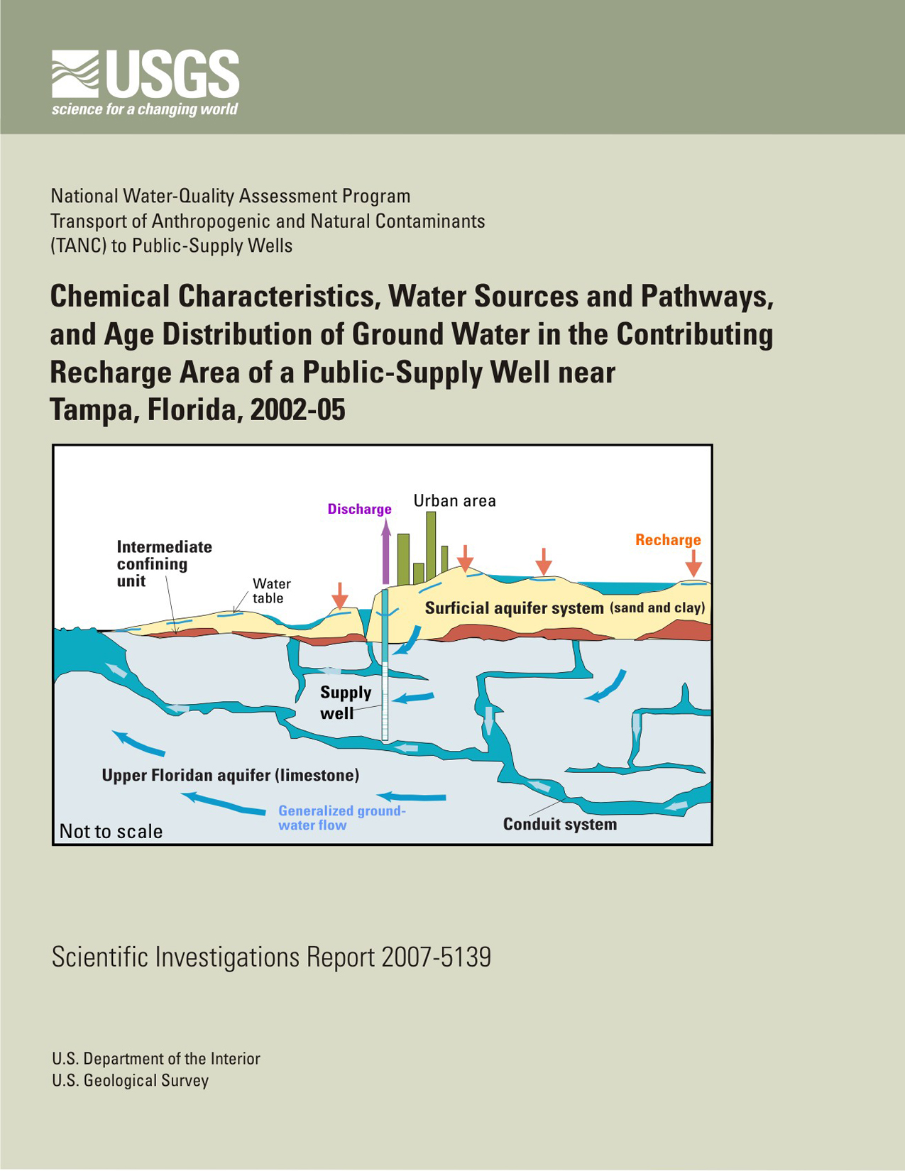
In the Temple Terrace study area near Tampa, Florida, multiple chemical indicators and geochemical and ground-water flow modeling techniques were used to assess the vulnerability of a public-supply well in the karstic Upper Floridan aquifer to contamination from anthropogenic and naturally occurring contaminants. During 2003-05, water samples were collected from the public-supply well and 13 surrounding monitoring wells that all tap the Upper Floridan aquifer, and from 15 monitoring wells in the overlying surficial aquifer system and the intermediate confining unit that are located within the modeled ground-water contributing recharge area of the public-supply well.
Six volatile organic compounds and four pesticides were detected in trace concentrations (well below drinking-water standards) in water from the public-supply well, which had an open interval from 36 to 53 meters below land surface. These contaminants were detected more frequently in water samples from monitoring wells in the overlying clastic surficial aquifer system than in water from monitoring wells in the Upper Floridan aquifer in the study area. Likewise, nitrate-N concentrations in the public-supply well (0.72-1.4 milligrams per liter) were more similar to median concentrations in the oxic surficial aquifer system (2.1 milligrams per liter) than to median nitrate-N concentrations in the anoxic Upper Floridan aquifer (0.06 milligram per liter) under sulfate-reducing conditions. High concentrations of radon-222 and uranium in the public-supply well compared to those in monitoring wells in the Upper Floridan aquifer appear to originate from water moving downward through sands and discontinuous clay lenses that overlie the aquifer.
Water samples also were collected from three overlapping depth intervals (38-53, 43-53, and 49-53 meters below land surface) in the public-supply well. The 49- to 53-meter interval was identified as a high-flow zone during geophysical logging of the wellbore. Water samples were collected from these depth intervals at a low pumping rate by placing a low-capacity submersible pump (less than 0.02 cubic meter per minute) at the top of each interval. To represent higher pumping conditions, a large-capacity portable submersible pump (1.6 cubic meters per minute) was placed near the top of the open interval; water-chemistry samples were collected using the low-capacity submersible pump. The 49- to 53-meter depth interval had distinctly different chemistry than the other two sampled intervals. Higher concentrations of nitrate-N, atrazine, radon, trichloromethane (chloroform), and arsenic (and high arsenic (V)/arsenic (III) ratios); lower concentrations of dissolved solids, strontium, iron, manganese, and lower nitrogen and sulfur isotope ratios were found in this highly transmissive zone in the limestone than in water from the two other depth intervals.
Movement of water likely occurs from the overlying sands and clays of the oxic surficial aquifer system and intermediate confining unit (that contains high radon-222 and nitrate-N concentrations) into the anoxic Upper Floridan aquifer (that contains low radon-222 and nitrate-N concentrations). Differences in arsenic concentrations in water from the various depth intervals in the public-supply well (3.2-19.0 micrograms per liter) were related to pumping conditions. The high arsenic concentrations found in the high flow zone during pumping conditions indicates that oxic water from the surficial aquifer system may travel into conduits in the Upper Floridan aquifer and mobilize arsenic from pyrite in the aquifer matrix.
Geochemical mass-balance mixing models for the public-supply well indicate that 50 to 70 percent of water withdrawn from the public-supply well is being contributed from the surficial aquifer system and 30 to 50 percent from the Upper Floridan aquifer. Geochemical models also indicate the dissolution of small amounts of calcite, gypsum, and dolomite as water moves toward the public-supply well.
Concentrations of age tracers sulfur hexafluoride (SF6), tritium (3H), and helium-3 (3He) in samples from the public-supply well during low- and high-rate pumping conditions were consistent with binary mixtures dominated by young water (less than 7 years). Similarly, water samples from monitoring wells in the surficial aquifer system had SF6 and 3H concentrations that indicate a substantial proportion of young water (less than 7 years). In contrast, most water samples from monitoring wells in the Upper Floridan aquifer had lower SF6 and 3H concentrations than water from the public-supply well, indicating mixtures containing higher proportions of older waters (greater than 50 years). The presence of young water (less than 7 years) in the public-supply well and surficial aquifer system indicates the vulnerability of public-supply wells in this area to contamination associated with highly transmissive zones in the Upper Floridan aquifer that are directly connected to the overlying surficial aquifer system.
Selected monitoring wells in the surficial aquifer
system were sampled several times during 2003-05 at different hydrologic conditions to evaluate temporal variability in water quality. These wells were sampled four times before and after three tropical cyclones that passed through the area in summer 2004. Additionally, water-quality variations were evaluated for the public-supply well based on five samples collected during 2002-05. Chloride concentrations decreased from the
summer 2004 water samples to the winter 2004-05 samples from three wells following the recharge pulse from high rainfall and corresponding peak in water-level elevation in October 2004. Nitrate-N concentrations increased in water from one well from January 2004 to August 2004, but decreased in water from another well during the same period. Nitrate-N concentrations also increased in water samples from two other monitoring wells in the surficial aquifer system, from January 2004 to August 2004, but decreased in subsequent samples from these two wells. Nitrate-N concentrations in water from a well located near the Hillsborough River remained below the detection limit, as reducing conditions persisted during December 2003 to July 2005. Dissolved oxygen concentrations increased in water samples from two wells in the surficial aquifer system, and the public-supply well in August and September 2004 during and following the above normal rainfall in June through September 2004. The increase in dissolved oxygen concentrations likely results from recent recharge of water containing high levels of oxygen compared to low levels in ground water prior to the excess rainfall period. Dissolved oxygen concentrations decreased in water from a well near the Hillsborough River in fall 2004, which may indicate the influx of river water with high dissolved organic carbon and subsequent consumption of oxygen as water moves toward this well.
Katz, B.G., Crandall, C.A., Metz, P.A., McBride, S., and Berndt, M.P., 2007, Chemical characteristics, water sources and pathways, and age distribution of ground water in the contributing recharge area of a public-supply well near Tampa, Florida, 2002-05: U.S. Geological Survey Scientific Investigations Report 2007-5139, 83 p.
U.S. Geological Survey
Florida Integrated Science Center
Suite 100
2010 Levy Avenue
Tallahassee, FL 32310
850-942-9500
| Accessibility FOIA Privacy Policies and Notices | U.S. Department of the Interior, U.S. Geological Survey
Persistent URL: https://pubs.usgs.gov/sir/2007/5139 Page Contact Information: USGS Publishing Network Page Last Modified: Thursday, 01-Dec-2016 20:01:00 EST |
 |