Volcano Hazards Program
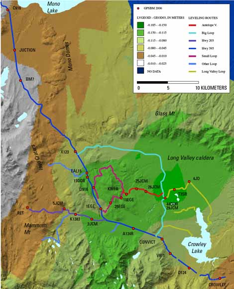
Map of the difference between LVGEOID and the GEOID03 NGS geoid height model in the Long Valley region (rom figure 5).
A GPS survey of leveling benchmarks done in Long Valley Caldera in 1999 showed that the application of the National Geodetic Survey (NGS) geoid model GEOID99 to tie GPS heights to historical leveling measurements would significantly underestimate the caldera ground deformation (known from other geodetic measurements). The NGS geoid model was able to correctly reproduce the shape of the deformation, but required a local adjustment to give a realistic estimate of the magnitude of the uplift. In summer 2006, the U.S. Geological Survey conducted a new leveling survey along two major routes crossing the Long Valley region from north to south (Hwy 395) and from east to west (Hwy 203 - Benton Crossing). At the same time, 25 leveling bench marks were occupied with dual frequency GPS receivers to provide a measurement of the ellipsoid heights. Using the heights from these two surveys, we were able to compute a precise geoid height model (LVGEOID) for the Long Valley volcanic region. Our results show that although the LVGEOID and the latest NGS GEOID03 model practically coincide in areas outside the caldera, there is a difference of up to 0.2 m between the two models within the caldera. Accounting for this difference is critical when using the geoid height model to estimate the ground deformation due to magmatic or tectonic activity in the caldera.
Download this report as a 39-page PDF file (sir2007-5255.pdf; 4.1 MB).
USGS Digital Data Series DDS-81, The Long Valley Caldera GIS database, by M. Battaglia, M.J. Williams, D.Y. Venezky, D.P. Hill, J.O. Langbein, C.D. Farrar, J.F. Howle, M. Sneed and P. Segall
USGS Professional Paper 1692, Eruptive History and Chemical Evolution of the Precaldera and Postcaldera Basalt-Dacite Sequences, Long Valley, California: Implications for Magma Sources, Current Seismic Unrest, and Future Volcanism, by Roy A. Bailey
For questions about the content of this report, contact Dave Hill
Suggested citation and version history
Download a free copy of the latest version of Adobe Reader.
|
Help |
PDF help |
Publications main page |
| Western Scientific Investigations Reports |
| Geologic Division | Volcano Hazards Program
This report is available only on the Web

![]() U.S. Department of the Interior | U.S. Geological Survey
U.S. Department of the Interior | U.S. Geological Survey
URL: https://pubs.usgs.gov/sir/2007/5255/
Page Contact Information: Michael Diggles
Page Last Modified: January 18, 2008