Scientific Investigations Report 2007–5261
U.S. GEOLOGICAL SURVEY
Scientific Investigations Report 2007–5261
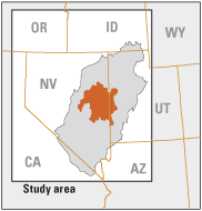
This report summarizes results of a water-resources study for White Pine County, Nevada, and adjacent areas in east‑central Nevada and western Utah. The Basin and Range carbonate-rock aquifer system (BARCAS) study was initiated in December 2004 through Federal legislation (Section 301(e) of the Lincoln County Conservation, Recreation, and Development Act of 2004; PL108-424) directing the Secretary of the Interior to complete a water-resources study through the U.S. Geological Survey, Desert Research Institute, and State of Utah. The study was designed as a regional water-resource assessment, with particular emphasis on summarizing the hydrogeologic framework and hydrologic processes that influence ground-water resources.
The study area includes 13 hydrographic areas that cover most of White Pine County; in this report however, results for the northern and central parts of Little Smoky Valley were combined and presented as one hydrographic area. Hydrographic areas are the basic geographic units used by the State of Nevada and Utah and local agencies for water-resource planning and management, and are commonly defined on the basis of surface-water drainage areas. Hydrographic areas were further divided into subbasins that are separated by areas where bedrock is at or near the land surface. Subbasins are the subdivisions used in this study for estimating recharge, discharge, and water budget. Hydrographic areas are the subdivision used for reporting summed and tabulated subbasin estimates.
Most ground water in the study area flows through three types of aquifers—a shallow basin-fill aquifer, a deeper volcanic-rock aquifer, and an underlying carbonate-rock aquifer that forms the base of the ground-water flow system. Relatively impermeable basement rocks underlie the carbonate-rock aquifer throughout most of the study area. The basin-fill aquifer underlies every valley and is the primary source of ground water for the area. Typical thicknesses of basin fill range from 0.3 to 0.9 miles; maximum thicknesses of basin fill range from about 1 mile to more than 3 miles. The volcanic-rock aquifer is thickest beneath the western and southern parts of the study area, extending laterally beneath the basin-fill aquifer in multiple hydrographic areas. Although some springs issue from volcanic rocks, these aquifers are not utilized as a significant source of water supply in the study area. Fractured, permeable carbonate rocks are regionally extensive, form many of the mountain ranges, and underlie the basin-fill and volcanic-rock aquifers throughout much of the study area. Ground water in the carbonate-rock aquifer discharges at perennial-flowing valley-floor springs and, because of the lateral continuity and relative high permeability of the carbonate rocks, most ground-water flow between adjacent valleys occurs through this aquifer. Although not a primary source of water supply in the study area, some ground water is pumped from the carbonate-rock aquifer for various uses.
The distribution of aquifers and units of low permeability along hydrographic area boundaries controls ground-water flow between hydrographic areas. Ground-water flow across some hydrographic area boundaries is negligible where carbonate or volcanic rocks are absent, or if the aggregate permeability of aquifers beneath a hydrographic area boundary is relatively low.
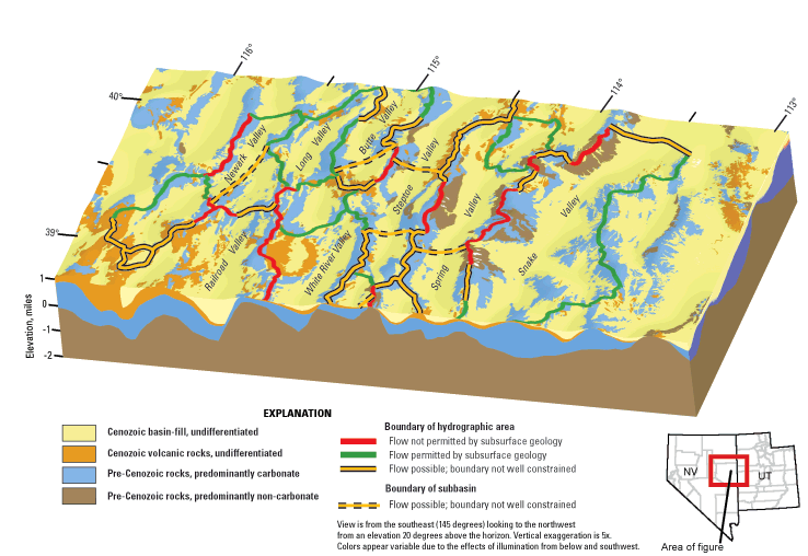
Perspective view of the primary aquifer systems.
Based on a subset of chemical constituents having National primary and secondary drinking-water standards, the inorganic chemical quality of ground water generally is acceptable for human consumption. For chemical constituents with available analyses from more than 25 sampling sites, only arsenic (2 sites) and fluoride (4 sites) exceeded their primary standards at more than 1 site. Secondary drinking-water standards were exceeded more often than the primary standards. A small number of analyses of anthropogenic organic compounds in ground water are available, and from these analyses only low concentrations of pesticides or their metabolites are reported, and no volatile organic compounds were detected.
The larger valleys in the study area, such as Steptoe, Snake, Spring, and White River Valleys, have the highest average annual ground-water recharge and discharge. The highest annual recharge occurs in Steptoe Valley (about 154,000 acre‑ft) and Snake Valley (about 111,000 acre-ft). Estimated annual recharge for Steptoe Valley is about 20,000 acre-ft higher than any previous estimate for this valley. The highest annual discharge occurs in Snake Valley (about 132,000 acre-ft) and Steptoe Valley (about 101,000 acre-ft). Estimated annual discharge for Snake Valley is significantly higher (about 45,000 acre-ft) than any previous estimate and the estimated annual discharge for Steptoe Valley is within the range of previous estimates.
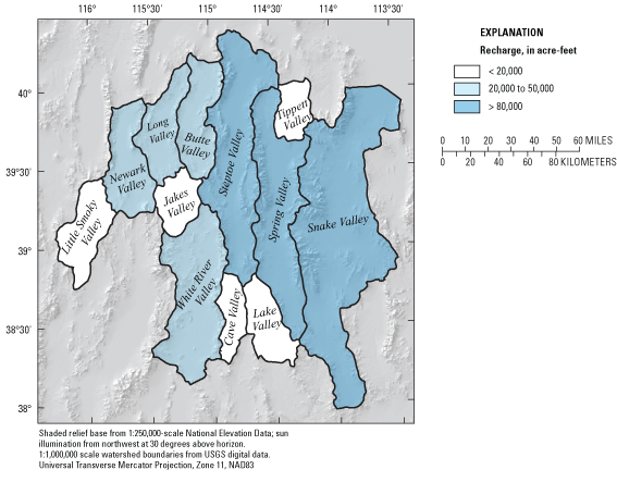
Average annual recharge to the ground-water system.
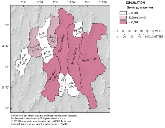
Average annual discharge from the ground-water system.
Differences in basin recharge and discharge provide a surplus or deficit of water that under equilibrium conditions is balanced by ground-water flow entering or exiting a valley as interbasin ground-water flow. Recharge exceeds pre-development discharge by 10,000 acre-ft or more on an average annual basis in almost one-half of the hydrographic areas (5 of 12). Recharge in Steptoe Valley annually exceeds pre-development discharge by about 53,000 acre-ft. The surplus of water in Steptoe Valley is the source of interbasin ground-water flow to multiple valleys. In contrast to Steptoe Valley, pre-development discharge annually exceeds the relatively low annual recharge in White River Valley by about 41,000 acre-ft, indicating that ground water lost to the atmosphere on the valley floor must be supported, in part, by subsurface inflow from adjacent valleys such as Steptoe Valley to the northeast, Jakes Valley to the north, and Cave Valley to the east. Estimates of the magnitude of interbasin flow through some hydrographic area boundaries differ from previous estimates. The largest differences are for the outflow estimated for southern Steptoe Valley, where previous investigations proposed zero outflow, and for southern Spring Valley. The estimated interbasin ground-water flow from southern Spring Valley to Snake Valley is about twice as high as any previous estimate.
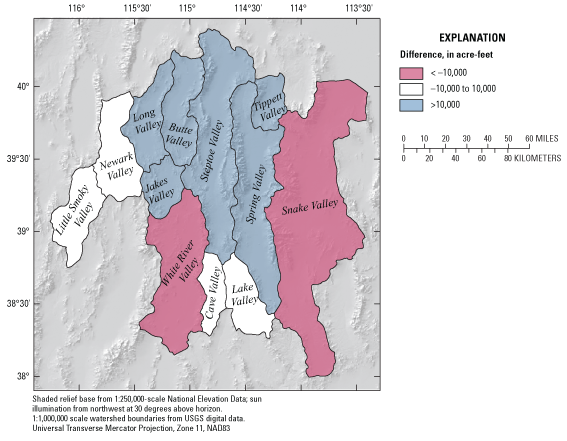
Difference between average annual ground-water recharge and discharge.
Carbonate rocks comprise much of the Egan, Schell Creek, and Snake Ranges, and the relatively high precipitation and recharge in these mountain ranges create a large mound that is a primary source of recharge to the ground-water flow systems in the basin-fill, volcanic-rock, and carbonate-rock aquifers of the study area. The Egan Range is the primary source area for northward ground-water flow through Butte Valley, and southward flow through Long, Jakes, and White River Valleys, where ground water exits the study area. The Egan and Schell Creek Ranges are the primary source areas for ground water in Steptoe Valley, where the highest water-level altitudes in the basin fill and carbonate-rock aquifers are found in the study area. Ground-water outflow from northern Steptoe Valley is toward the northeast and exits the study area. Ground-water outflow from central Steptoe Valley is to Jakes and northern White River Valleys; and outflow from southern Steptoe Valley is to Lake and southern Spring Valleys. The latter two flow paths from central and southern Steptoe Valley have not been identified in previous investigations. Southeasterly flow from southern Steptoe Valley suggests that southern Steptoe and Lake Valleys may be part of the Great Salt Lake Desert regional flow system. Southwesterly flow from central Steptoe Valley suggests that central Steptoe Valley may be part of the Colorado regional flow system. The Schell Creek and Snake Ranges are the primary source areas for northeastward ground-water flow through northern Spring, Tippett, and Snake Valleys. Ground water exits the study area from Snake and Tippett Valleys and flows northeastward toward a terminal discharge area in the Great Salt Lake Desert. Most ground-water flow likely exits the study area through Snake (29,000 acre-ft/yr), Butte (8,000 acre-ft/yr), Tippett (12,000 acre-ft/yr), and White River Valleys (39,000 acre-ft/yr).
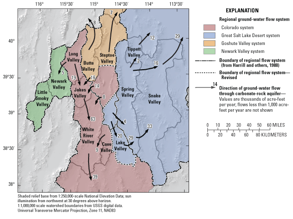
Ground-water flow through the Colorado, Great Salt Lake Desert, and other regional flow systems.
Average annual recharge equals 530,000 acre-ft, and average annual ground-water discharge equals 440,000 acre-ft for the entire study area under pre‑development conditions. The difference between recharge and discharge indicates that about 90,000 acre-ft of ground water exits the study area annually by subsurface outflow.
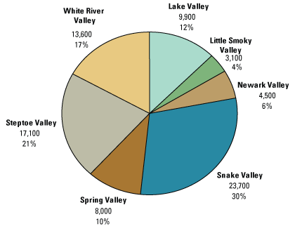
Percentage and volume, in acre-feet, of net regional ground-water use by hydrographic area.
The net amount of regional ground water removed from the study area was estimated to evaluate the significance of the ground-water withdrawn to ground-water discharged under pre‑development conditions. Net regional ground-water use for the study area is about 80,000 acre-ft and includes the amount of water pumped from wells or diverted from regional springs minus excess water returned from mining, irrigation applications, or public supply that infiltrated and recharged the ground-water system. The net ground-water use of 80,000 acre-ft nearly equals the estimated quantity of ground-water outflow from the study area (about 90,000 acre-ft/yr). On a regional scale, this condition suggests that the long-term use of ground water at a rate of 80,000 acre-ft could capture much of the estimated average annual volume of ground water exiting the study area under pre-development conditions. These withdrawals also could, in some combination, decrease other discharge components such as interbasin flow, spring discharge, or discharge by vegetation, or increase subsurface recharge from adjacent basins. However, actual decreases in ground-water outflow would be controlled by a number of factors, particularly, the spatial distribution of ground-water withdrawals, and the volume of ground-water removed from storage. For example, decreases in outflow would be less likely in Butte or Tippett Valleys where net ground-water use was zero in 2005. Decreases in outflow would be more likely in subbasins or hydrographic areas where net ground-water use is nearly equal to or greater than the estimated outflow, such as in Snake Valley where net ground-water use was 24,000 acre-ft in 2005 and average annual ground-water outflow was estimated at 29,000 acre-ft. However, for ground-water withdrawals from the basin-fill aquifer, the relatively large volume of water stored in this aquifer likely will mitigate current or near-future decreases in the volume of ground-water outflow or other pre-development discharge components. Water-level measurements, water-use records, and data on pre-development discharge indicate that ground-water pumping has not significantly altered local evapotranspiration rates, the distribution of native vegetation, or regional springflow in the study area.
Although some uncertainty exists on estimated differences between annual recharge and pre-development discharge, a prevalence of hydrographic areas where recharge exceeds discharge and a significant quantity of subsurface outflow from the entire study area (90,000 acre-ft/yr) are not unexpected. Recharge estimates were model-derived; the accuracy of these estimates depends on the accuracy with which a number of hydrologic, atmospheric, and soil parameters were estimated. Estimates of pre-development discharge were derived through field measurements and, as a result of a more direct method of measurement, the uncertainty of estimated pre-development discharge is likely less than the uncertainty of estimated recharge. Future studies may reduce uncertainties of estimated recharge and discharge by evaluating a regional ground-water flow system bounded by ground-water divides, such as the Colorado or Great Salt Lake Desert regional flow systems. Evaluating entire regional flow systems provides the constraint that ground-water inflow and outflow across the study area boundary is minimal; therefore, cumulative recharge and pre-development discharge must balance for hydrographic areas within the regional flow system.

![]() U.S. Department of the Interior | U.S. Geological Survey
U.S. Department of the Interior | U.S. Geological Survey
URL: https://pubs.usgs.gov/sir/2007/5261
Page Contact Information: Publications Team
Page Last Modified: Thursday, 01-Dec-2016 20:00:04 EST
