Scientific Investigations Report 2007–5261
U.S. GEOLOGICAL SURVEY
Scientific Investigations Report 2007–5261
Table 7. Evapotranspiration (ET) units identified, delineated, and mapped for different vegetation and soil conditions in potential areas of ground-water discharge in the Basin and Range carbonate-rock aquifer system study area, Nevada and Utah, September 2005–August 2006.
| ET-unit name | ET-unit description | Photograph |
|---|---|---|
| Xerophytic | Area of no substantial ground-water evaporation. Area dominated by bare dry soil and/or sparse, non-phreatophytic vegetation. | |
| Open Water | Area of open water including reservoirs, ponds, and spring pools. | 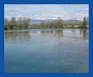 |
| Marshland | Area dominated by dense wetland vegetation, primarily tall reeds and rushes, and some grasses. Vegetation cover typically is greater than 50 percent. Open water is present but typically less than 25 percent. Perennially flooded. Water at or very near surface. Depth to water typically is less than 1 foot. | 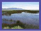 |
| Meadowland | Area dominated by short, dense perennial grasses, primarily marsh and meadow grasses. Unit includes occasional desert shrubs and trees, primarily Rocky Mountain junipers and cottonwoods. Vegetation cover typically is greater than 50 percent. Soil typically is moist except in later summer and autumn. Depth to water table typically is less than 5 feet. | 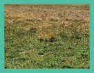 |
| Grassland | Area dominated by short, sparse, perennial grasses, including salt grass, and sod and pasture grasses typically a mix of vegetation types. Unit includes sparse desert shrubs and occasional trees, primarily Rocky Mountain junipers or cottonwoods. Vegetation cover is between 10 and 100 percent. Soil typically is damp to dry. Depth to water table typically is less than 8 feet. | 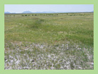 |
| Moist Bare Soil | Area dominated by moist playa. Near surface soil is damp throughout much of the year. Water table is near or below land surface. Depth to water typically is less than 10 feet. | 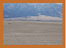 |
| Dense Desert Shrubland | Area dominated by sparse desert shrubs, including greasewood, rabbitbrush, shadscale, big sagebrush, and saltbush. Shrubs typically are mixed. Vegetation cover typically is greater than 25 percent. Depth to water can range from about 3 to 50 feet. | 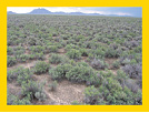 |
| Moderately Dense Desert Shrubland | Area dominated by sparse desert shrubs, including greasewood, rabbitbrush, shadscale, big sagebrush, and saltbush. Shrubs typically are mixed. Vegetation cover typically ranges from 10 to 30 percent. Depth to water can range from about 3 to 50 feet. | 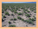 |
| Sparse Desert Shrubland | Area dominated by sparse desert shrubs, including greasewood, rabbitbrush, shadscale, big sagebrush, and saltbush. Shrubs typically are mixed. Vegetation cover typically ranges from 5 to 15 percent. Depth to water can range from about 3 to 50 feet. | 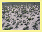 |
| Dry Playa | Area dominated by dry playa. Soil typically dry year round. Water table below land surface. Depth to water typically is greater than 10 feet. This unit may not contribute to ground-water discharge. | 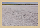 |
| Recently Irrigated Cropland—Historically Mixed Phreatophyte | Area dominated by irrigated cropland. Soil moisture varies with irrigation practice. Water table is below land surface. Depth to water table typically is greater than 5 feet. Prior to irrigation, the unit likely was dominated by sparse desert shrubs to grassland. | 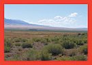 |

![]() U.S. Department of the Interior | U.S. Geological Survey
U.S. Department of the Interior | U.S. Geological Survey
URL: https://pubs.usgs.gov/sir/2007/5261
Page Contact Information: Publications Team
Page Last Modified: Thursday, 01-Dec-2016 19:59:33 EST
