Geographic Analysis and Monitoring Program
In cooperation with the Washington Military Department Emergency Management Division
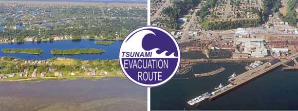
The incorporated cities of Ocean Shores (left) and Port Angeles (right) on the Washington coast, shown with the internationally adopted tsunami-evacuation sign. (Photographs from the Washington Department of Ecology, 2007).
Evidence of past events and modeling of potential future events suggest that tsunamis are significant threats to communities on the open-ocean and Strait of Juan de Fuca coasts of Washington. Although potential tsunami-inundation zones from a Cascadia Subduction Zone (CSZ) earthquake have been delineated, the amount and type of human development in tsunami-prone areas have not been documented. A vulnerability assessment using geographic-information-system tools was conducted to document variations in developed land, human populations, economic assets, and critical facilities relative to CSZ-related tsunami-inundation zones among communities on the open-ocean and Strait of Juan de Fuca coasts of Washington (including Clallam, Jefferson, Grays Harbor, and Pacific Counties). The tsunami-inundation zone in these counties contains 42,972 residents (24 percent of the total study-area population), 24,934 employees (33 percent of the total labor force), and 17,029 daily visitors to coastal Washington State Parks. The tsunami-inundation zone also contains 2,908 businesses that generate $4.6 billion in annual sales volume (31 and 40 percent of study-area totals, respectively) and tax parcels with a combined total value of $4.5 billion (25 percent of the study-area total). Although occupancy values are not known for each site, the tsunami-inundation zone also contains numerous dependent-population facilities (for example, schools and child-day-care centers), public venues (for example, religious organizations), and critical facilities (for example, police stations and public-work facilities). Racial diversity of residents in tsunami-prone areas is low89 percent of residents are White and 8 percent are American Indian or Alaska Native. Nineteen percent of the residents in the tsunami-inundation zone are over 65 years in age, 30 percent of the residents live on unincorporated county lands, and 35 percent of the households are renter occupied. Employees in the tsunami-inundation zone are largely in businesses related to health care and social assistance, accommodation and food services, and retail trade, reflecting businesses that cater to a growing retiree and tourist population. Community vulnerability, described here by exposure (the amount of assets in tsunami-prone areas) and sensitivity (the relative percentage of assets in tsunami-prone areas) varies among 13 incorporated cities, 7 Indian reservations, and 4 counties. The City of Aberdeen has the highest relative community exposure to tsunamis, whereas the City of Long Beach has the highest relative community sensitivity. Levels of community exposure and sensitivity to tsunamis are found to be related to the amount and percentage, respectively, of a community’s land that is in a tsunami-inundation zone. This report will further the dialogue on societal risk to tsunami hazards in Washington and help risk managers to determine where additional risk-reduction strategies may be needed
Download this report as a 44-page PDF file (sir2008-5004.pdf; 2.7 MB)
Go to the Data folder. This folder contains the project database as a five-layer Excel workbook as well as a subfolder that contains five comma-separated-value (.csv) files, one for each layer in the database (sir2008-5004_data; 224 kB total).
For questions about the content of this report, contact Nathan Wood.
Suggested citation and version history
Download a free copy of the latest version of Adobe Reader.
|
Help |
PDF help |
Publications main page |
| Western Scientific Investigations Reports |
| Geography | Geographic Analysis and Monitoring Program
|

![]() U.S. Department of the Interior | U.S. Geological Survey
U.S. Department of the Interior | U.S. Geological Survey
URL: http://pubs.usgs.gov/sir/2008/5004/
Page Contact Information: Michael Diggles
Page Last Modified: February 14, 2008