USGS Scientific Investigations Report 2008-5023
<--Return to Contents
KARST MAPPING
By David J. Weary1, Daniel H. Doctor1, Jack B. Epstein1, and Randall C. Orndorff2
1U.S. Geological Survey, 12201
Sunrise valley Drive, MS 926A,
Reston,
VA
20192
2U.S. Geological Survey, 12201
Sunrise valley Drive, MS 908,
Reston,
VA
20192
Download PDF [6.6 MB].
Adobe Reader is required to view the report. A free copy of the Adobe Reader may be downloaded from Adobe Systems Incorporated.
Compilation of a new national karst map based on lithologic descriptions chiefly derived from state geologic maps is complete. This is a first approximation of areas with potential for karst development in carbonate, evaporate, and volcanic (features analogous to karst) rocks. Classification schemes are being developed to further subdivide these areas into useful karst type divisions. Since karst landscapes exhibit variable development in different areas of the United States , we need to first develop a geographic classification hierarchy. Implementation of a system similar to the ecologic classification scheme of Bailey and others (1994) would enable organization of karst areas within naturally defined regions of the United States and provide a framework under which multidisciplinary karst research can be organized at all scales.
As the initial phase of compilation of a new national karst map is nearing completion, the next logical steps are to refine the delineation of potentially karstic areas and also to segregate karst areas within a geographic framework, preferably along natural boundaries. We propose to organize karst in the United States into a nested hierarchy of geographic areas similar to the ecological classification scheme of Bailey and others (1994).
A preliminary map of potentially karstic areas of the conterminous United States, based primarily on state-scale (1:24,000 up to 1:1,000,000) geologic maps, has been constructed (fig. 1). This map reflects the presence of soluble bedrock lithologies, carbonate and evaporite rocks, or low-viscosity lava extrusive volcanic rocks. These are the most important factors in developing karst or volcanic pseudokarst. Lava tube caves are predominantly found in rocks younger than about 40 million years old, so areas of older volcanic rock have been deleted (Palmer, 2007; Kolev and Shopov, 1992). This is a first approximation of potentially karstic, or volcanic pseudokarstic areas based on compilations from state geologic maps and is a work in progress.
The National Atlas Engineering Aspects of Karst map (Davies and others,1984) catagorized carbonate karst areas by (1) generalized length and depth of fissures, tubes, and caves; (2) general lithologic type; and (3) structural setting (steeply dipping versus flat-lying rocks).
As part of the national karst map project, a regional map of Appalachian karst has been constructed (Weary, 2008, unpublished data). This map covering the states of New York, Pennsylvania, New Jersey, Delaware, Ohio, West Virginia, Maryland, Virginia, Kentucky, Tennessee, North Carolina, South Carolina, Georgia, Alabama, and Mississippi, is in the final stages of technical review for publication as an online Open-file Report and should be available by the time of the May, 2008 USGS karst Interest Group (KIG) meeting.
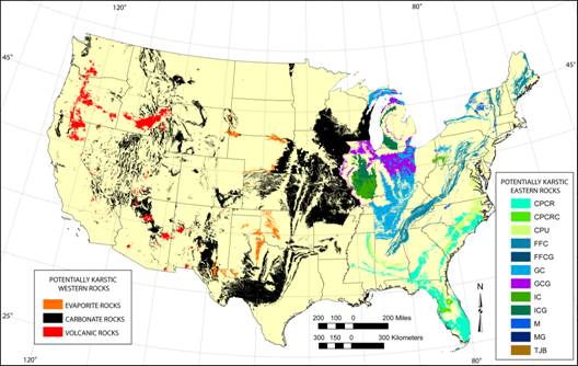 |
Figure 1. Potentially karstic areas of the conterminous United States delineated from mapping of surficial expression of carbonate, evaporate, and relatively young (Post Oligocene) volcanic rocks. See text for a description of map units.
The potentially karstic units on the Appalachian karst map are classified in similar fashion to the map of Davies and others (1984), although for the time being, cave length and depth are being ignored. The units from the Appalachian map are incorporated into figure 1 with extension of its classification scheme into the states of Florida, Indiana, Michigan, Wisconsin, as well as the New England states. The map units are: (1) CPCR, Coastal Plain carbonate rocks; (2) CPCRC, Coastal Plain carbonate rocks with a siliciclastic overburden up to 200 ft thick (chiefly in Florida); (3) CPU, Coastal Plain unconsolidated carbonate rich sediments; (4) FFC, folded and faulted carbonate rocks, chiefly limestone and dolostone in the Valley and Ridge physiographic Provence (Fenneman and Johnson, 1946); (5) FFCG, folded and faulted carbonate rocks, with a glacially derived overburden of at least 50 ft (15.2 m); (6) GC, gently folded to flat-lying carbonate rocks, chiefly found in the Appalachian Plateaus, Central Lowlands, and Interior Low Plateaus; (7) GCG, gently folded to flat-lying carbonate rocks, with a glacially derived overburden of at least 50 ft (15.2 m); (8) IC, carbonates interbedded with relatively insoluble rocks, chiefly in the cyclothemic rocks of the Appalachian, Michigan, and Illinois basins; (9) ICG, carbonates interbedded with relatively insoluble rocks, with a glacially derived overburden of at least 50 ft (15.2 m); (10) M, marble, found chiefly in the Piedmont, Blue Ridge, and Adirondack physiographic provinces; (11) MG, marble with a glacially derived overburden of at least 50 ft (15.2 m); (12) TJB, carbonate rocks in Triassic and Jurassic aged basins of the Piedmont.
In states west of the Mississippi, potentially karstic areas are currently shown as simply carbonate, evaporate, or, volcanic rocks. Portrayal of karst areas in the states of California, Oregon, Washington, Arizona, and Utah has been refined in more detail based on interaction with local experts, from the state geological surveys and members of the National Speleological Society (NSS). Work is ongoing to devise an appropriate classification scheme for western karst areas.
The longer we work towards a new national karst map, and the more requests and inquiries we field for various derivative maps and data, the more apparent it becomes that there is a need for an organizational framework for classifying karst areas in the United States. One advantage to establishing a national framework is the ability to integrate data and research within it from national scale surveys down to site-specific studies.
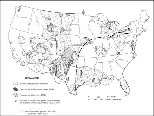
Figure 2. Map showing distribution of outcropping and subsurface evaporite rocks in the conterminous United States and areas of reported evaporite karst. The 32.5-in. ( mean-annual-precipitation line approximates the boundary between eastern and western karst (from Epstein and Johnson, 2003, fig. 5.).
On a national scale, the two most important factors in development and expression of karst landforms are amount of precipitation and the solubility of the bedrock. It has been observed that karst terrains in the eastern part of the U.S. are dominantly areas underlain by carbonate rocks with large numbers of sinkholes developed on them. In the western part of the country, sinkholes in carbonates are far fewer and surface expression of sinkholes and other karst features in areas underlain by evaporate rocks become common (Epstein and Johnson, 2003). The dividing line between these areas lies approximately along the 32.5 in. (826 mm) mean annual precipitation line (figure 2). A relatively detailed precipitation map overlain with areas of carbonate and evaporate rocks from our new national map (figure 3) shows this same pattern. Note that there are smaller areas of relatively high precipitation in the western part of the country in the Pacific Northwest, Sierra Nevada and Rocky Mountains.
The karst classification scheme of Davies and others (1984) and the scheme used on the new Appalachian regional map (Weary, 2008, unpublished data) are based primarily on geologic factors: rock type, tectonic setting, and thickness of insoluble overburden. These data alone are not sufficient for parsing karst areas into smaller units, and the areas, as depicted, do not always coincide with natural physiographic and ecologic boundaries. In the quest for further subdivision of the karst map, and in lieu of availability of extensive karst feature data sets, our approach was to follow physiographic mapping, for which the US is organized into a 3-tiered, nested hierarchy of topographically defined divisions, provinces, and sections (Fenneman and Johnson, 1946) (figure 4) The physical characteristics of each of these physiographic regions are the result of the geologic and climate/erosional history of each area over long geologic time scales. Many of the section boundaries coincide with boundaries of known karst terrains (e.g. the Ozark Plateaus, the Adirondacks, etc). The boundaries of the physiographic sections in some areas of the country do not correspond well to present precipitation patterns as their characteristics are the result of time-averaging of the climatic effect over the age of each landscape rather than present weather patterns. This long-term climate/erosion history is also related to the epigenetic karstification history of each landscape.
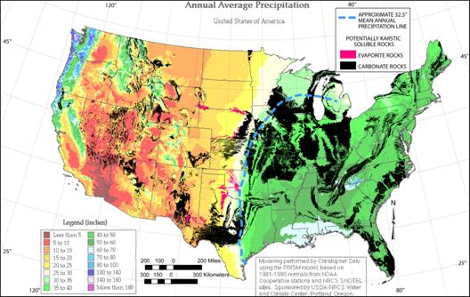 |
Figure 3. Map showing the surface distribution of carbonate and evaporate rocks of the conterminous United States and detailed mean-annual-precipitation. Precipitation map from the Oregon Climate Center, online link: http://www.wrcc.dri.edu/pcpn/us_precip.gif.
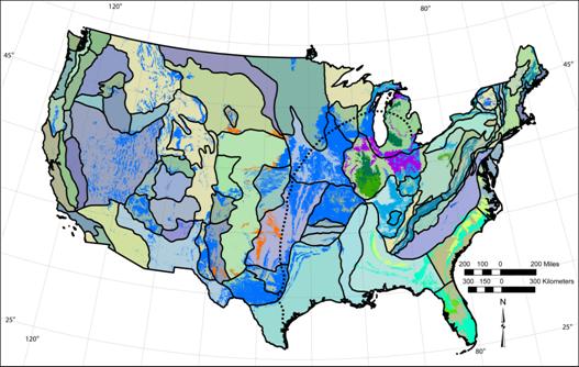 |
Figure 4. Map of the conterminous United States showing physiographic sections (outlined in black, not labeled for clarity), areas of soluble bedrock (superimposed unbounded areas, see figure 1), and the approximate location of the 32.5 in. (826 mm) mean annual precipitation line (dashed).
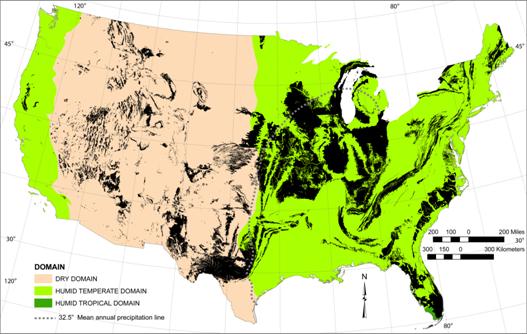 |
Figure 5. Map of the conterminous United States showing ecologic Domains with areas of soluble rock overlain (see figure 1). The 32.5 in. (826 mm) mean annual precipitation line from figure 3 included for reference.
A better choice for organizing karst terrains in the U.S. is the use of a scheme similar to ecologic landtype classification. Many states and other agencies follow the ecoregion classifications scheme of Bailey and others (1994) or similar hierarchical classifications that incorporate climate, geology, and physical and biological features that are significant for natural resource management. Because the ecoregion scheme considers factors related to climate, it tends to fit the precipitation patterns better than the physiographic hierarchy. Another advantage of using this scheme is that it incorporates factors that have biologic importance and thus makes a suitable framework for biologic studies at various scales.
The largest unit in the ecologic classification scheme is the Domain. These are continental-scale areas defined by climate, primarily precipitation (figure 5, table 1). Notice that there are non-contiguous Humid Temperate Domains in the east and the west. The boundary between the Dry Domain and the eastern Humid Temperate Domain follows the 32.5 in (826 mm) mean annual precipitation line fairly closely in the southern half of the midwest.
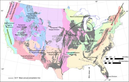
Figure 6. Map of the conterminous United States showing ecologic Divisions. 32.5 in. (826 mm) mean annual precipitation line from figure 3 included for reference.
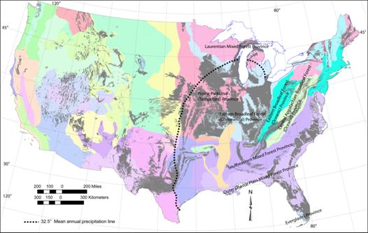
Figure 7. Map of the conterminous United States showing ecologic Provinces (only some labeled). 32.5 in. (826 mm) mean annual precipitation line from figure 3 included for reference.
The next level down in the classification scheme is the Division. These are regional-scale areas defined primarily by climate and relief (figure 6, table 1). Divisions are then subdivided into Provinces (figure 7, table 1). Provinces are regional-scale areas combining predominant vegetation and climate patterns.
Provinces are, in turn, divided into Sections and Subsections (figure 8, table 1). The Sections often coincide with large karst terranes like the Ozark Highlands and the Subsections are at the level of specific karst areas like the Ozark Highlands and the Subsections are at the level of specific karst areas like the Springfield Plateau, Woodville Karst Plain, Mitchell Karst Plain, and Pennyroyal Plateau (figure 8). It is at about the Section level that various karst constants (Curl, 1966), or karst development and karst vulnerability scoring or indexing studies such as EPIK (Doerflinger and Zwahlen, 2000) and a new Karst Potential Index (KPI) being developed for Kentucky (Currens and others, 2004, unpublished manuscript) may be applied. At this scale the weights of various factors affecting karstification should be relatively uniform within each Section.
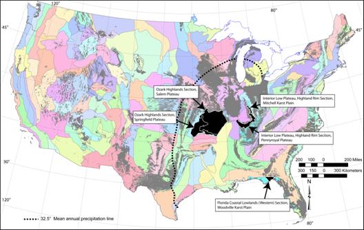
Figure 8. Map of the conterminous United States showing ecologic Sections and subsections (only some labeled). 32.5 in. (826 mm) mean annual precipitation line from figure 3 included for reference.
Below the level of Subsection in the ecologic hierarchy are Landtype Associations and Landtype Phases (table 1). In karst terranes these may be equivalent in scale to karst basins and then discrete karst features such as sinkholes or areas underlain by caves respectively. Most karst research studies occur within these levels.
A GIS copy of ecologic landtype polygons at each level in the hierarchy can easily be overlain on the distribution of carbonate, evaporate and volcanic rocks on the national map to facilitate assignment of the various karst areas within the classification scheme. Since this is a karst classification, names of the various units could be altered to make more sense in a karst/physiographic frame of reference (table 1).
For example, at the Province level it makes more sense for karst scientists to use "Midcontinent Karst Province" than "Eastern Broadleaf Forest (Continental) Province”. At lower levels in the classification, previously named karst terrains would have precedence and retain their historic names (e.g. Woodville Karst Plain).
Table 1. Example of an ecologic landtype-based classification (Bailey and others, 1994) and a suggested parallel karst classification using an Ozark karst area.
General size range |
Ecological Units |
Ecological Unit Examples |
Karst Terrane Units |
Suggested Karst example |
Millions to tens of thousands of square miles |
Domain |
Humid Temperate Domain |
Karst Domain |
Humid Temperate karst of eastern North America |
Division |
Hot Continental Division |
Karst division |
Allegheny/Cumberland Plateau and Midcontinent karst |
|
Province |
Eastern Broadleaf Forest (Continental) Province |
Karst Province |
Midcontinent Karst Province |
|
Hundreds of square miles |
Section |
Ozark Highlands Section |
Karst Section |
Ozark Highlands Karst Section |
Subsection |
Current-Eleven Point Hills Subsection |
Karst Subsection |
Salem Plateau Karst Subsection |
|
Thousands to hundreds of acres |
Landtype Association |
Ozark Limestone/Dolomite Glade/Woodland Hills, Knobs, and Basins |
Karst Basin |
Big Spring Karst Basin |
Hundreds to less than ten acres |
Landtype Phase |
North-facing dolomite cliffs |
Karst Feature |
Jam Up Cave |
There is a need for organizing the karst lands of the United States, and by extension, North America, into a hierarchical geographic classification scheme. We suggest a system paralleling the ecologic classification scheme of Bailey and others (1994) which is widely used by natural resource agencies across the country. This would link the karst classification to both physiographic and biological factors and establish a framework for organizing karst data at all scales.
Bailey, R.G.; Avers, P.E.; King, T.; McNab, W. H., eds. 1994. Ecoregions and subregions of the United States: U.S. Geological Survey, Accompanied by a supplementary table of map unit descriptions compiled and edited by McNab, W.H., and Bailey, R.G., Prepared for the U.S. Department of Agriculture, Forest Service, Scale 1: 7,500,000.
Curl, R.L., 1966, Caves as a measure of karst: Journal of Geology, v. 74, no. 5, pt. 2, p. 798-830.
Currens, J.C., Paylor, M., and Crawford, M., 2004, Karst potential and development indices; tools for maping and comparing karst development at the local or regional scale: Kentucky Geological Survey, unpublished manuscript, 45 p.
Davies, W.E., Simpson, J.H., Ohlmacher, G.C., Kirk, W.S., and Newton, E.G., 1984, Engineering aspects of karst: U.S. Geological Survey, National Atlas, scale 1:7,5000.
Doerflinger, N. and Zwahlen, F., 2000, Groundwater vulnerability mapping in karstic regons (EPIK): Swiss Agency for the Environment, Forests, and Landscapes, Berne, VU-2504-E, 56 P.
Epstein, J.B., and Johnson, K.S., 2003, The need for a national evaporate karst map, in Johnson, K.S. and Neal, J.T., eds., Evaporite karst and engineering/environmental problems in the United States: Norman, Oklahoma Geological Survey, Circular 109, p. 21-30
Fenneman, N.M., and Johnson, D.W., 1946, Physiographic divisions of the conterminous U. S. : U.S. Geological Survey special map series, scale 1:7,000,000.
Kolev, B., and Shopov, Y., 1992, Volcanic caves in Bulgaria : Huntsville, AL , National Speleological Society, Proceedings of 6th International symposium on volcanospeleology, p. 171-175.
Palmer, A.N., 2007, Cave Geology: Dayton, OH, Cave Books, 454 p.

![]() U.S. Department of the Interior |
U.S. Geological Survey
U.S. Department of the Interior |
U.S. Geological Survey
URL: http://pubsdata.usgs.gov/pubs/sir/2008/5023/07weary.htm
Page Contact Information: Eve L. Kuniansky
Page Last Modified: Thursday, 10-Jan-2013 15:23:25 EST
