USGS Scientific Investigations Report 2008-5023
<--Return to Contents
KARST AQUIFER SYSTEMS
By Rodney Tennyson1, Jim Terry2, Van Brahana3, Phil Hays4, and Erik Pollock5
1MOLES, 1303 CR 919,
Alpena,
AR
72611
2MOLES, 1103 W. Olive,
Rogers,
AR
72756
3Department of Geosciences, 113 Ozark,
University of
Arkansas,
Fayetteville,
AR
72701 and Research Hydrologist
Emeritus,
U.S. Geological Survey
4Department of Geosciences and
U.S.
Geological Survey, 113 Ozark,
University of
Arkansas,
Fayetteville,
AR
72701
5Stable Isotope Lab, Department of Biological Sciences,
University of
Arkansas,
Fayetteville,
AR
72701
Download PDF [4.2 MB].
Adobe Reader is required to view the report. A free copy of the Adobe Reader may be downloaded from Adobe Systems Incorporated.
The Ozark Plateaus are an ancient, variably karstified region of the mid-continent that have more than 8000 reported caves, tens of thousands of springs, and a wide and diverse suite of accompanying karst landforms and hydrogeologic features. The importance of aquifers of the Ozark Plateaus led to their inclusion as one of the initial National Water-Quality Assessment study units in 1991, and the resulting studies have enhanced significantly our understanding of the processes and controls affecting water quality throughout the region.
This report describes the integration of recent data from diverse types of research to develop a conceptual model of hypogene speleogenesis for one selected data set of cave and karst locations within the Ozark Plateaus that overlie or are contiguous to deep basement faults. Data encompass geologic mapping, cave mapping, structural geology, gravity mapping, hydrogeology, ground-water tracing, endangered species distribution mapping, cave mineralogy, stable-isotope geochemistry, and fluid inclusion studies. This conceptual model draws on reactivation of preexisting basement faults during tectonic pulses, with the formation of caves and selected cave minerals created by geothermally heated water that recharged from below along integrated systematic joints and faults, driven by hydrostatic pressure. Structurally, flow pathways and cave passages range from slightly-tilted blocks (dips generally less than several degrees), to numerous fault features, only a few of which are of a magnitude to be shown on published geological quadrangle maps. Although most of these faults and fractures are not regional in scale, they appear to be very important at controlling ground-water flow that formed cavern passages. Cave erosional features and deposits have been found that indicate past episodes of thermal ground-water circulation. These include upper-level paleo-cave passages and chambers, now reactivated by present-day stream drainage, dolomite breccia linings, and remarkable dog-tooth spar (calcite) crystals, some of which are as long as 1.9 meters. The stable isotopic signature of these crystals is anomalous, and inconsistent with a meteoric fluid origin. Although the source of the thermal water is not known with certainty at this time, the proximity of these features and deposits to basement faults is consistent with upwelling of deep basin brines, and may likely be related to economic mineral deposits found nearby. Soft-sediment deformation, in the form of olistoliths, is documented from one recently excavated road cut within 50 meters of the northeast-trending Bella Vista fault, indicating that movement on basement faults was active as early as Osagean time. Gravity data and deep drilling records reflect the displacement of basement rocks across major faults, and distribution of several endangered species suggest that brittle overlying carbonate rocks were fractured and that the faults served as pathways for dispersal of these species, as well as flow conduits. Although these tectonically controlled karst features likely impact a small component of NAWQA sites in the Ozark Plateaus, the depth of faulting and the vertical interconnectivity warrants additional scrutiny, especially near areas of these northeast-trending basement faults.
The Ozark Plateaus (figure 1) are an ancient, variably karstified region of the mid-continent that have more than 8000 reported caves, tens of thousands of springs, and a wide and diverse suite of accompanying karst landforms and hydrogeologic features (Imes and Emmett, 1994; Brahana et al., 2005). The importance of aquifers of the Ozark Plateaus led to their inclusion as one of the initial National Water-Quality Assessment (NAWQA) study units in 1991 (Leahy et al., 1990), and the resulting studies have enhanced significantly our understanding of the processes and controls affecting water quality throughout the region.
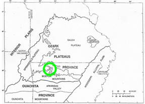
Figure 1. The Ozark Plateaus, showing the approximate location of northeast-trending basement faults in northern Arkansas. The Upper Flatrock Creek fault study area is shown by the circle in figure 2 (modified from Imes and Emmett, 1994).
Whereas the Ozark Plateaus NAWQA studies focused on karst formed by epigenetic processes, hypogenic karst also is present within the Ozarks, although it has seldom been recognized or been the object of major research. Epigenetic karst is formed by aggressive recharge descending from the land surface; hypogenic karst is formed by aggressive recharge ascending from ground water under artesian conditions. The distinction between these types of karst and the dominant factors that control them has been rapidly evolving over the past several decades, and only recently has been clearly elucidated (Hill, 2000; Klimchouk, 2007). The full understanding of these differences requires different management practices for water quality and land use for each, and has implications for future regional studies the Survey may undertake.
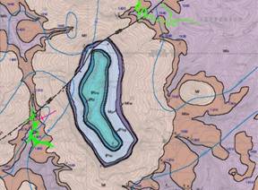
Figure 2. Relation of the northeast-trending Flatrock Creek fault to the surface geology and cave locations (shown in green). Chilly Bowl Cave is furthest west, Endless Cave is furthest east, and Big Hole Cave is in between (modified from Hudson and Murray, 2004). North is at the top of the figure. The width of the map is approximately 5 kilometers.
This report focuses on a subset of hypogenetic features that overlie deep northeast-trending faults that extend from land surface to the basement in northern Arkansas, and specifically, the area of the Upper Flatrock Creek fault in Newton County. We herein describe the integration of data from diverse research incorporating geologic mapping (Hudson, 1998; Hudson et al., 2001; Braden and Ausbrooks, 2003; and Hudson and Murray, 2004), cave mapping (David Taylor, 2008, written commun., Clarksville, Arkansas), structural geology (Granath, 1989; Hudson, 2001), gravity mapping (Hendricks et al., 1981), hydrogeology (Brahana, 1997), ground-water tracing (Dawn Cannon, 2001, written commun., Fayetteville, Arkansas; Chuck Bitting, 2008, written commun., Harrison, Arkansas), endangered species distribution mapping (Brown and Graening, 2003), cave mineralogy, stable-isotope geochemistry (P.D. Hays, 2008, written commun., Fayetteville, Arkansas), economic mineral occurrence (McKnight, 1935), and fluid inclusion studies (Leach, 1979; Leach and Rowan, 1986) to constrain our understanding of the factors that control hydrogeology and karst development in the region, both hypogenic and epigenetic.
The purpose of this study is to develop a preliminary conceptual model of hypogene speleogenesis for areas of the Ozark Plateaus that overlie reactivated Precambrian faults. The term hypogene speleogenesis used herein follows the definition of Ford (2006), in which "the formation of caves is by water that recharges the soluble formation from below, driven by hydrostatic pressure or other sources of energy, independent of recharge from the overlying or immediately adjacent surface." The lack of discernible genetic relation with recharge from the overlying surface is the main characteristic of this process (Klimchouk, 2007).
This report is limited in scope to the six-county area of northwest Arkansas, where major faults are well defined by mapping and remote sensing (Haley et al., 1993; Hudson, 1998; Hudson et al., 2001; Braden and Ausbrooks, 2003; and Hudson and Murray, 2004). Emphasis and most examples are drawn from Newton County, and specifically the Flatrock Creek fault (figure 2).
This report is limited in scope to the six-county area of northwest Arkansas, where major faults are well defined by mapping and remote sensing (Haley et al., 1993; Hudson, 1998; Hudson et al., 2001; Braden and Ausbrooks, 2003; and Hudson and Murray, 2004). Emphasis and most examples are drawn from Newton County, and specifically the Flatrock Creek fault (figure 2).
A recent program to refine geologic mapping at a 1:24,000 scale within and near the study area has been undertaken by several agencies and universities, most notably the U.S. Geological Survey, the National Park Service, the Arkansas Geological Commission, and the University of Arkansas (Hudson, 1998; Hudson et al., 2001; Braden and Ausbrooks, 2003; and Hudson and Murray, 2004). Surface geology in the six-county study area ranges in age from Ordovician to Pennsylvanian. Lithologies include a thick sequence of carbonate rocks in the deeper part of the section, with dolomite dominant up to the Ordovician, and limestone dominant from the Ordovician through the middle Mississippian (figure 3). The Boone Formation, a major karst former in the region, has significant (as much as 70%) chert throughout much of the area. The chert and other insoluble materials mantle surface-karst features, and provide a distinct nonkarst appearance to the untrained eye, especially in that portion of the northwest Arkansas Ozarks classified as the Springfield Plateau (figure 1). Terrigenous sediments characterize Mississippian though Pennsylvanian rocks, with shales dominant, and interlayered sandstones and limestones forming local aquifers. The shales shed most of their recharge laterally to surface streams, and recharge and karst development below shale outcrops is limited, although locally it may be well developed if fracturing prevails.
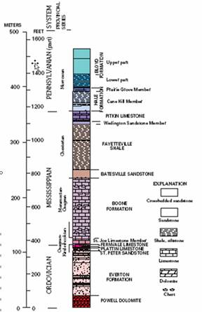
Figure 3. Partial stratigraphic column in the area of interest (modified from Hudson and Murray, 2004).
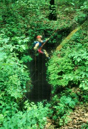
Figure 4. Entrance into Chilly Bowl Cave requires a double-pitched rappel of about 25 meters. The vertical relief in caves in this part of the Ozarks reflects uplift that is thought to be related to Ouachita tectonics.
Structurally, the rocks in this area are nearly flat-lying. Dips typically are less than 3o, except for locations where faulting has occurred. Uplift is observed to increase from west to east across the study area, and near Flatrock Creek fault, in Newton County, and the nearby Buffalo National River, river bluffs and vertical cave entrances (figures 4 and 5) are consistent with uplift of from tens to hundreds of meters compared with the same formations in nearby counties (Fanning, 1994). Fracturing dominates the structural geology ( Hudson, 2001) suggesting that the sedimentary cover overlying these formations was thin.
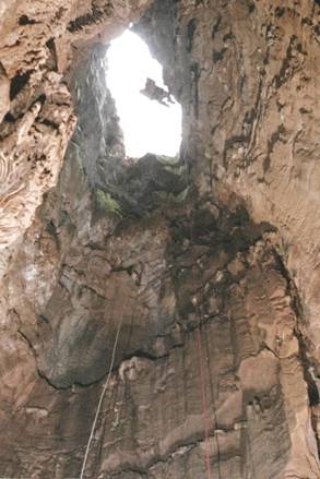
Figure 5. View from inside Big Hole Cave looking up at the entrance about 38 meters above.
Within Chilly Bowl Cave, faults are common (figure 6) and clearly visible (figure 7). Only a few of these faults are of a magnitude to be shown on published geological quadrangle maps at a scale of 1:24,000, however (Hudson, 1998; Hudson et al., 2001; Braden and Ausbrooks, 2003; and Hudson and Murray, 2004). Most of these individual faults appear to be very important at controlling ground-water flow that formed cavern passages.
Bouguer gravity anomalies suggest that reactivation of basement faults has been a major control on fracturing in this part of the Ozarks (Hendricks et al., 1981). Deep drilling records are yet additional data sources that reflect the displacement of basement rocks across major faults (Hendricks et al., 1981). The occurrence, symmetry, and magnitude of the anomalies is such that basement rocks are required to be involved; rocks of the sedimentary cover alone cannot explain the observed data. Brahana (1997) has used orthogonal fracturing to successfully delineate spring basins boundaries in shallow karst aquifers elsewhere in the region, and the mechanism proposed appears to be applicable to Newton County, as well.
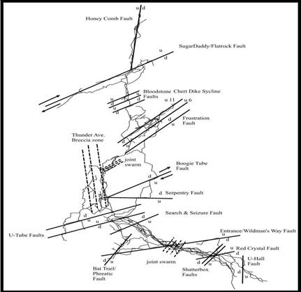
Figure 6. Plan view of Chilly Bowl Cave illustrating the tectonic control and faulting that are present and mapped within the cave.
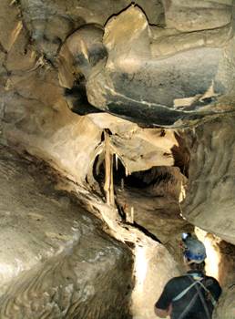
Figure 7. Tube and canyon development on Boogie Tube Fault in Chilly Bowl Cave.
Hydrogeologically, flow pathways and cave passages tend to be aligned and to lie on near-horizontal bedding planes of slightly-tilted blocks (Brahana, 1997), or along near-vertical shafts that follow joints and fractures. In a cave such as Chilly Bowl, dozens of faults and fracture features are common (figure 6).
Hydraulic gradients of the present ground-water flow system, which generally appear to follow the tilt (structural dip) of the rock formations, act independently (are decoupled) from surface-water bodies where confinement by chert layers in the Boone Formation is effective. This decoupling is also lithologically controlled, but in areas of faults and major joints, exhibits strong structural control. Stream piracy is one manifestation of combined lithologic and structural control that is obvious.
Dye tracing studies within (Dawn Cannon, 2000, written commun., Fayetteville, Arkansas) and near the study area (Tom Aley, 2004, written commun., Protem, Missouri) indicate that flow beneath surface drainage basins is common, that passages formed by hypogene processes likely have been pirated by later epigenetic processes, with a reversal of flow, and that faults in the system also may act as ground-water dams (figure 11).
The distribution of endangered species of cave crayfish and cavefish [Cambarus setosis, Cambarus aculabrum, and Ambyopsis rosea] (Brown and Graening, 2003; David Kampwerth, 2008, written commun., Conway, Arkansas) suggest that brittle overlying carbonate rocks were fractured from basement to land surface. These dominant faults underwent dissolution and later served as pathways for dispersal of subterranean species, as well as flow conduits for ground-water. These species are found in caves that lie at the distal end of the flow system and are large enough for human entry. Hydrocarbon spills in the southern Missouri part of the Ozarks indicate that endangered species live within carbonate aquifers, and are not restricted just to caves. In several reported instances, dead cavefish were observed where spills occurred yet no caves were present (Carol Wicks, 2001, written commun., Columbia, Missouri).
Soft-sediment deformation, in the form of olistoliths (figure 10), is documented from one recently excavated road cut within 50 meters of a major northeast-trending basement fault (Bella Vista fault). This outcrop lies near the highway 412 bridge that crosses the Illinois River near Robinson, in Benton County (~123 km east of the Flatrock Creek fault), indicative that movement on this basement fault was active as early as Osagean time, when St. Joe sediments had yet to be indurated (Chandler, 2001). Energy released from the surface waves associated with this faulting had to be significant enough to initiate sliding on basal bedding plane with a dip of about 3o.
Cave mapping (figure 6) indicates that passages in Chilly Bowl Cave appear to have been formed by recharge from below along integrated systematic joints and faults (figures 6 and 10), driven by hydrostatic pressure. Erosional features and deposits have been found that indicate past episodes of thermal ground-water circulation, with scallops in conduits and flow tubes showing upward flow (figure 7). Additional documentation of thermal hypogene flow includes upper-level paleo-cave passages and chambers, now reactivated by present-day stream drainage, dolomite breccia linings on cave walls, and remarkable, beautifully preserved large crystals of dog-tooth spar (figures 8 and 9). These crystals occur in the highest level of the cave, and are protected from erosion above by a sandstone caprock. Piracy of surface streams and surface drainage has been diverted to lower levels in the cave (figure 11) by older hypogene features, bypassing those few remaining passages where the crystals have been spared. Uranium series dating of these crystals is currently in progress.
Stable-isotopic analyses of samples taken from a transect of one of these broken dog-tooth spar crystals in situ from Chilly Bowl Cave reveal an anomalous d13C signature. The d13C has a strong organic carbon signature (~ -20 per mil), unlike other calcite samples from the region (P.D. Hays, 2008, written commun., Fayetteville, Arkansas). Although speculative at this time, one hypothesized source is the organic-rich, Arkoma hydrocarbon basin that overlies on the flowpath from the Ouachita Mountains in the south to our study area in northern Arkansas.
Economic minerals (sphalerite, galena, and chalcopyrite) are present in the Rush mining district (McKnight, 1935), north and east of the study area, and are disseminated throughout much of the area in noncommercial quantities. Although these are not directly related to the karst focus of this report, the source of the metals and the details of the hydrogeology associated with mineral emplacement is hypothesized to be the same as with the hypogene fluids responsible for early karst initiation along Flatrock Creek Fault.
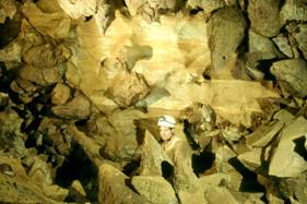
Figure 8. An upper-level passage in Chilly Bowl Cave, uniquely preserved with large dogtooth spar crystals that are thought to have been precipitated by thermal brines from hypogene sources. The caver’s head serves as scale.
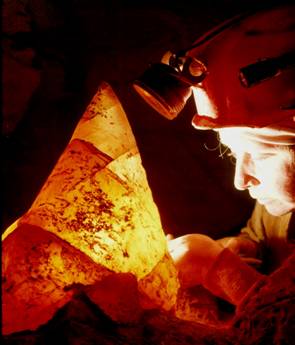
Figure 9. Backlit dogtooth spar crystal from Chilly Bowl Cave showing incipient cleavage planes. A broken sample from an in situ crystal was used for stable isotope analysis.
Fluid-inclusion research (Leach, 1979; Leach and Rowan, 1986) provide insight into the hot temperatures of mineralizing fluids that were hypothesized to have been expelled northward from the Arkoma Basin through permeable Paleozoic carbonate rocks toward the Ozark uplift. Using homogenization temperatures of fluid inclusions in sphalerite, these authors showed a northward cooling of deep basinal brines that deposited sphalerite; temperatures ranged from ~120o C at ~100 kilometers north of the Ouachita Mountains to ~80o C in deposits ~400 kilometers north of the Ouachitas. The hydrogeology associated with these deposits appears to be quite similar to the study area.
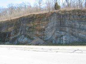
Figure 10. Soft-sediment deformation (olistoliths) caused by intense shaking of slightly dipping sediments thought to be caused by an earthquake on the nearby Bella Vista fault, which underlies a valley approximately 50 meters from the right edge of the photo. Olistoliths indicate that faulting on these major northeast-trending basement faults was active at least as early as St. Joe time. The Northview Shale, with a dip toward the fault of about 3o, served as the glide plane along which the loose sediments slid (after Chandler, 2001).
The compilation briefly discussed herein yields a preliminary conceptual model of hypogene speleogenesis (figures 11 and 12) that is consistent with all available data from a wide range of disciplines. Simply, the Ouachita orogeny was the driving force for fluid migration, basinal sediments of the Arkoma reactivated basement faults supplied the preexisting faults, created preferred flow paths for fluid flow, faulting on reactivated basement faults provided the major pathways of upward vertical migration into near-surface carbonates, the geothermal gradient supplied the heat, and the shale and sandstone cover of terrigenous sedimentary rocks supplied the insulation and pressure confinement such that the heated water
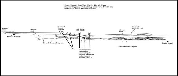
Figure 11. Conceptual profile of Chilly Bowl Cave illustrating the vertical speleogenetic development, major faulting associated with the Flatrock Creek fault, current level of Davis Creek, current base level, the top of the Boone Formation, and sources of thermal input that are preserved within the cave.
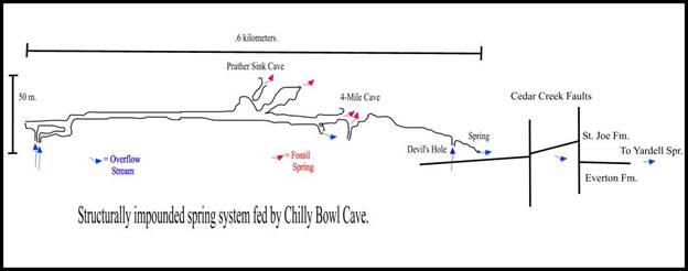 |
Figure 12. Conceptual flow system currently active in Chilly Bowl Cave showing the damming nature of multiple faults at the distal end of the integrated drainage way.
was advectively transported and cooled slowly. The strength of the crystalline basement rocks allowed much of the energy transmission, acting as a broad, thick lever to facilitate uplift. Uplift was responsible for fracturing the relatively thin overlying sedimentary cover in a systematic stress field of orthogonal jointed and faulted rocks. This overlying cover was karstified with multiple pulses of deep hot water, especially in areas overlying the deep faults. Epigenetic karstification was overprinted based on local factors, primarily hydrologic (Brahana et al., 1988). Insofar as NAWQA focused on epigenetic karst aquifers, it seems justified to reassess sampling sites along deep-seated faults.
Braden, A.K., and Ausbrooks, S.M., 2003, Geologic map of the Mt. Judea quadrangle, Newton County, Arkansas: Arkansas Geological Commission Digital Geologic Quadrangle Map DGM-AR-00590, scale 1:24,000.
Brahana, J.V., 1997, Rationale and methodology for approximating spring-basin boundaries in the mantled karst terrain of the Springfield Plateau, northwestern Arkansas: in Beck, B.F. and Stephenson, J. Brad, eds., Sixth Multidisciplinary Conference on Engineering Geology and Hydrogeology of Karst Terranes, A.A. Balkema, Rotterdam, p. 77-82.
Brahana, J.V., Thrailkill, John, Freeman, Tom, and Ward, W.C., 1988, Carbonate rocks: in Back, W. Rosenshein, J.S., and Seaber, P.R., eds., Hydrogeology, Boulder, CO, Geological Society of America, The Geology of North America, v. O-2, p. 333-352.
Brahana, J.V., Hays, P.D., Al-Qinna, Mohammed, Murdoch, John F., Davis, Ralph K., Killingbeck, Jonathan J., Szilvagyi, Eva, Doheny-Skubic, Margaret, Chaubey, Indrajeet, Ting, Tiong Ee, and Thoma, G., 2005, Quantification of hydrologic budget parameters for the vadose zone and epikarst in mantled karst: in Kuniansky, E.L., 2005, U.S. Geological Survey Karst Interest Group proceedings, Rapid City, South Dakota, September 12-15, 2005: U.S. Geological Survey Scientific Investigations Report 2005-5160, p. 144-152.
Chandler, Sandra L., 2001, Carbonate olistoliths, St. Joe and Boone Limestones (Lower Mississippian), northwestern Arkansas: unpublished M.S. thesis, University of Arkansas, Fayetteville, 49 p.
Fanning, B.J., 1994, Geospeleologic analysis of cave and karst development within the Boone and St. Joe Formations of Benton and Madison counties,Northwest Arkansas: unpublished M.S. thesis, University of Arkansas, Fayetteville, 144 p.
Fischer, M.P., and Christensen, R.D., 2004, Insights into the growth of basement uplifts deduced from a study of fracture systems in the San Rafael monocline, east central Utah: Tectonics, v. 23, p. TC1018, doi: 10.1029/2002TC001470.
Fischer, M.P., and Jackson, P.B., 1999, Stratigraphic controls on deformation patterns in fault-related folds: A detachment fold example from the Sierra Madre Oriental, northeast Mexico : Journal of Structural Geology, v. 21, p. 613-633, doi: 10.1016/S0191-8141(99)00044-9.
Ford, D.C., 2006, Karst geomorphology, caves and cave deposits: A review of North American contributions during the past half century: in Harmon, R.S., and Wicks, C.W., eds., Perspectives on Karst Geomorphology, Hydrology, and Geochemistry, Geological Society of America Special Paper 404, Boulder, Colorado, p. 1-14.
Granath, J.W., 1989, Structural evolution of the Ardmore Basin, Oklahoma: Progressive deformation in the foreland of the Ouachita collision: Tectonics, v. 8, p. 1015-1036.
Hale-Erlich, W.S., and Coleman, J.L., Jr., 1993, Ouachita-Appalachian juncture: A Paleozoic transpressional zone in the southeastern U.S.A.: American Association of Petroleum Geologists (AAPG) Bulletin, v. 77, p. 553-568.
Haley, B.R., Glick, E.E., Bush, W.V., Clardy, B.F., Stone, C.G., Woodward, M.B., and Zachry, D.L., 1993, Geologic map of Arkansas: Arkansas Geological Commission and U.S. Geological Survey, scale 1:500,000.
Hendricks, J.D., Keller, G.R., and Hildenbrand, T.G., 1981, Bouguer gravity map of Arkansas: U.S. Geological Survey Geophysical Investigations Map GP-944, scale 1:500,000.
Hill, C.A. , 2000, Sulfuric acid hypogene karst in the Guadalupe Mountains of Klimchouk, Alexander, Ford, D.C., Palmer, A.N., Dreybrodt, Wolfgang, 2000, Speleogenesis-Evolution of karst aquifers: National Speleological Society, Huntsville, Alabama, p. 309-316.
Houseknecht, D.W., and Matthews, S.M., 1985, Thermal maturity of Carboniferous strata, Ouachita Mountains: American Association of Petroleum Geologists (AAPG) Bulletin, v. 69, p. 335-345.
Hudson, M.R., 1998, Geologic map of parts of the Jasper, Hasty, Ponca, Gaither, and Harrison quadrangles in and adjacent to the Buffalo National River, northwestern Arkansas: U.S. Geological Survey Open-File Report 98-116, scale 1:24,000.
Hudson, M.R., 2001, Coordinated strike-slip and normal faulting in the southern Ozark dome of northern Arkansas-Deformation in a late Paleozoic foreland: Geology, v. 28, p. 511-514.
Hudson, M.R. and Murray, K.E., 2004, Geologic map of the Hasty Quadrangle, Boone and Newton Counties, Arkansas: U.S. Geological Survey Scientific Investigations Map 2847, Version 1.0, scale 1:24,000.
Hudson, M.R., Murray, K.E., and Pezzutti, D., 2001, Geologic map of the Jasper quadrangle, Newton and Boone Counties, Arkansas: U.S. Geological Survey Miscellaneous Field Studies Map MF-2356, scale 1:24,000.
Imes, J.L. and Emmett, L.F., 1994, Geohydrology of the Ozark Plateaus aquifer system in parts of Missouri, Arkansas, Oklahoma, and Kansas: U.S. Geological Survey Professional Paper 1414-D, 127 p.
Ingebritsen, S.E., Sanford, W.E., and Neuzil, C.E., 2007, Groundwater in geologic processes: Cambridge University Press, 2nd ed., 334 p.
Klimchouk, Alexander, 2007, Hypogene Speleogenesis: Hydrogeological and morphogenetic perspective: National Cave and Karst Research Institute Special Paper No. 1, 106 p.
Klimchouk, Alexander, Ford, D.C., Palmer, A.N., Dreybrodt, Wolfgang, 2000, Speleogenesis-Evolution of karst aquifers: National Speleological Society, Huntsville, Alabama, 527 Kranjc, Andrej, Gabrovsek, Franci, Culver, David C., and Sasowsky, Ira D., 2007, Time in karst: Karst Waters Institute Special Publication 12, Charles Town, West Virginia, 246 p.
Leach, D. L, 1979, Temperature and salinity of the fluids responsible for minor occurrences of sphalerite in the Ozark region of Missouri: Economic Geology, v. 74, p. 931-937.
Leach, D.L. and Rowan, E.L., 1986, Genetic link between Ouachita foldbelt tectonism and the Mississippi Valley-type lead-zinc deposits of the Ozarks, Geology, v. 14, p. 931-935.
Leahy, P.P., Rosenshein, J.S., and Knopman, D.S., 1990, Implementation plan for the National Water-Quality Assessment Program: U.S. Geological Survey Open-File Report 90-174, 10 p.
McKnight, E.T., 1935, Zinc and lead deposits of northern Arkansas: U.S. Geological Survey Bulletin 853, 311 p.
Meckel, L.D., Smith, D.G., and Wells, L.A., 1992, Ouachita foredeep basins: Regional paleogeography and habitat of hydrocarbons, in Macqueen, R.W., and Leckie, D.A., eds., Foreland basins and fold belts: Tulsa, Oklahoma, American Association of Petroleum Geologists Memoir 55, p. 427-444.
Palmer, A.N., 2007, Cave Geology: Cave Books, Dayton, Ohio, 454 p.
Viele, G.W., and Thomas, W.A., 1989, Tectonic synthesis of the Ouachita orogenic belt, in Hatcher, R.D., Jr., Thomas, W.A., and Viele, G.W., eds., The Appalachian-Ouachita orogen in the United States: Boulder, Colorado, Geological Society of America, The Geology of North America, v. F-2, p. 695-728.
Withjack, M.O. and Jamison, W.R., 1986, Deformation produced by oblique rifting: Tectonophysics, v. 126, p. 99-124.

![]() U.S. Department of the Interior |
U.S. Geological Survey
U.S. Department of the Interior |
U.S. Geological Survey
URL: http://pubsdata.usgs.gov/pubs/sir/2008/5023/09tennyson.htm
Page Contact Information: Eve L. Kuniansky
Page Last Modified: Thursday, 10-Jan-2013 15:23:27 EST