USGS Scientific Investigations Report 2008-5023
<--Return to Contents
KARST AQUIFER SYSTEMS
By Rheannon M. Scheiderer and Joel M. Galloway
U.S. Geological Survey, 401 Hardin Road, Little Rock, AR 72211, Tele: 501-228-3600 Fax: 501-228-3601, Email: rmscheid@usgs.gov, jgallowa@usgs.gov
Download PDF [100 kB].
Adobe Reader is required to view the report. A free copy of the Adobe Reader may be downloaded from Adobe Systems Incorporated.
Nesbitt Spring, located in north-central Arkansas, lies within the Springfield Plateau section of the Ozark Plateaus physiographic province (Fenneman and Johnson, 1946) and is known to be an important habitat for the Hell Creek crayfish (Cambarus zophonastes), a federally listed endangered species. Nesbitt Spring, a privately owned spring, is one of two known locations where the rare crayfish is found (Graening and others, 2006). The source, occurrence, local recharge, and age of the waters discharging from Nesbitt Spring were characterized to better understand threats to the endangered species' habitat. The hydrogeologic framework of the area includes karst terrain; hence, the cave is susceptible to contamination from surface sources within its local-recharge area. The predominant land use within the local recharge area of Nesbitt Spring is agricultural (poultry and cattle) and mixed forest.
Nesbitt Spring discharges from the Ordovician-age Plattin Limestone but it receives recharge through the overlying Mississippian-age Boone Formation of the Springfield Plateau aquifer (http://waterdata.usgs.gov/nwis/qw) (fig. 1). Two water samples were collected from Nesbitt Spring (above base flow and base flow conditions; February 2006 and July 2006, respectively) and analyzed for major ions, radioactive isotopes, and stable isotopes. The water-quality characteristic were similar to water from wells and springs sampled within the Boone Formation where the flow is mainly conduit controlled and concentrated along joints and bedding planes. The age and recharge characteristics of Nesbitt Spring's discharge were determined using radioactive and stable isotopes of carbon, hydrogen, and oxygen. Oxygen and hydrogen stable isotope data indicate precipitation is infiltrating quickly with little time for evaporation, and tritium data indicate the water discharging from Nesbitt Spring is a mixture of modern and submodern water.
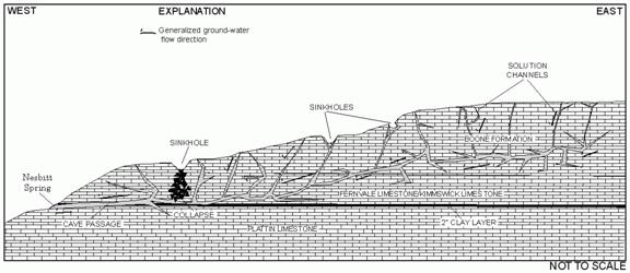 |
Figure 1. Conceptual model of Nesbitt Spring with geology and generalized flowpaths.
Dye tracer tests were performed and stage, water temperature, and precipitation were monitored to aid in the estimation of the local-recharge area and to help define flow characteristics. Three separate fluorescent dyes were used for simultaneous injection into open sinkholes or swallow holes and two of the dyes were recovered. The dyes were collected on passive charcoal detectors and positive detections were used to establish flow paths, but not to quantify the tracer concentrations.
Hydrograph-separation techniques (Base Flow Index computer program (Wahl and Wahl, 1995)) were applied to the spring hydrograph to determine relative proportions of local flow and regional flow. The contribution of regional flow to the spring was obtained by determining base flow; based on stormflow and dye tracer data, infiltration is occurring at a close proximity to the spring and accounts for the contribution of local flow. The spring responded rapidly to storm events with a range in recession time of 2 to 3 days, depending on the size of the event. The average daily discharge for the period of record (2006) was 4.51 cubic feet per second with a large component being base flow (47 percent), probably from the regional ground-water system. Water-temperature variations (ranging from 13.3 to 14.9 degrees Celsius) were observed seasonally and during storm events. The local-recharge area for Nesbitt Spring was estimated at approximately 2.5 square miles based on geologic characteristics, a water balance equation using spring discharge (Galloway, 2004), and dye tracer tests.
Fenneman, N.M., and Johnson, D.W., 1946, Physical divisions of the United States (Map): Washington, D.C., U.S. Geological Survey.
Galloway, J.M., 2004, Hydrogeologic characteristics of four public drinking-water supply springs in northern Arkansas: U.S. Geological Survey Water-Resources Investigations Report 03-4307, 68 p.
Graening, G.O., Koppelman, J.B., Wagner, B.K., Slay, M.E., and Brickey, C.L., 2006, Range extension and status update of the endangered Hell Creek Cave crayfish, Cambarus zophonastes (Decapoda: Cambaridae): The Southwestern Naturalist, vol. 51, no. 3, p. 392-396.
Wahl, K.L. and Wahl, T.L., 1995, Determining the flow of Comal Springs at New Braunsfel, Texas: Proceedings of Texas Water '95, A Component Conference of the First International Conference of Water Resources Engineering, American Society of Civil Engineers, August 16-17, 1995, San Antonio, Texas, p. 77-86.

![]() U.S. Department of the Interior |
U.S. Geological Survey
U.S. Department of the Interior |
U.S. Geological Survey
URL: http://pubsdata.usgs.gov/pubs/sir/2008/5023/10scheiderer.htm
Page Contact Information: Eve L. Kuniansky
Page Last Modified: Thursday, 10-Jan-2013 15:23:28 EST