USGS Scientific Investigations Report 2008-5023
<--Return to Contents
KARST AQUIFER SYSTEMS
By Lawrence E. Spangler
U.S. Geological Survey, 2329 Orton Circle, Salt Lake City, Utah 84119
Download PDF [1.9 MB].
Adobe Reader is required to view the report. A free copy of the Adobe Reader may be downloaded from Adobe Systems Incorporated.
In October 2006, the U.S. Geological Survey in cooperation with the U.S. Forest Service began a 3-year study to investigate the hydrology and water quality of the Mammoth Spring watershed in southwestern Utah. The principal objective of this study is to delineate the recharge area and ground-water flow system for Mammoth Spring and determine its relation to the surface-water drainage basin. The scope of the study includes (1) identifying potential point sources such as losing streams and sinkholes where surface water can rapidly recharge and impact the aquifer directly, (2) determining ground-water travel times through the aquifer, and (3) determining variations in water quality of Mammoth Spring during base and peak flow conditions.
Mammoth Spring is one of the largest springs in Utah, with a discharge that ranges from less than 5 to over 300 cubic feet per second (cfs) (Mundorff, 1971). The spring discharges at an altitude of 8200 feet on the Markagunt Plateau in Dixie National Forest, about 6 miles east of Cedar Breaks National Monument (NM) (fig. 1). Flow from Mammoth Spring immediately merges with Mammoth Creek, the principal outlet for surface flow within the watershed. Seepage from lower reaches of the creek and from tributaries to the creek may be possible sources of water to the spring. Discharge from Mammoth Spring is probably from Quaternary-age volcanic rock (basalt) that caps large parts of the Markagunt Plateau and overlies the Tertiary-age Claron Formation, a marly limestone that is locally cavernous (Moore and others, 2004). Dissolution within the Claron and subsequent collapse of the basalt have resulted in an extensive volcanokarstic terrain at an altitude of about 9500 feet, which is characterized by ephemeral sinking streams and sinkholes (dolines) as much as 100 feet deep. Recharge to the aquifer that supplies Mammoth Spring likely takes place by both focused and diffuse infiltration through the highly-permeable basalt and into the underlying limestone. Previous tracer studies in the Navajo Lake watershed immediately south of the Mammoth Spring watershed, have shown ground-water travel times through the basalt and underlying limestone ranging from 348 to 750 feet per hour, and bifurcations of ground-water flow paths that ultimately discharge into different surface-water drainage basins (Wilson and Thomas, 1964). Ground-water movement in the Navajo Lake watershed and likely in the Mammoth Spring watershed is along fractures or lineaments, rubble zones between successive basalt flows, and in lava tubes (basalt) or caves (limestone).
Water samples for major ions, selected trace metals, nutrients (nitrate plus nitrite, ammonia, and orthophosphate), gross alpha/beta, coliform bacteria, selected isotopes (oxygen/deuterium, sulfur-35, tritium) and chlorofluorocarbons (CFCs) were collected from Mammoth Spring during base flow conditions (less than 10 cfs) in the fall and winter of 2006-2007. Results of chemical analyses indicate a calcium-bicarbonate type water containing very low dissolved-solids concentrations (about 100 milligrams per liter (mg/L)) that are more characteristic of ground water that has been in contact with basalt than with the underlying limestone. Water samples collected from Arch Cave Spring, which discharges from the Claron Formation within Cedar Breaks NM, are characterized by considerably higher dissolved-solids concentrations (170 mg/L), more representative of flow within carbonate rock. Analyses of water samples collected from several other springs near Mammoth Spring may represent a mixture of water from both the basalt and limestone. Results of analyses for sulfur-35, tritium, and CFCs indicate that residence time within the aquifer that supplies Mammoth Spring probably is a mixture of short (months or less) and long-term (years) components. Samples collected during base flow when most water is presumed to be from storage within the fractured matrix, contained CFC-11, 12, and 113 concentrations that indicate an apparent age of about 6 years or younger since recharge and tritium concentrations of 28.4 picocuries/Liter (8.8 tritium units). In addition, results of analysis for sulfur-35, an age-dating tool for waters less than about 2 years old (87-day half-life), showed concentrations of 0 millibequerels/Liter (mBq/L) during base flow conditions to about 4.0 mBq/L at the onset of snowmelt runoff, indicating ground-water residence times that are greater than 2 years to less than 6 months, respectively.
Continuous monitoring of springflow (stage), specific conductance, and water temperature from November 2006 to November 2007 also shows a response to snowmelt runoff and rainfall events that is indicative of potentially rapid ground-water residence times (fig. 2). During this period, which represents one snowmelt runoff cycle, water temperature ranged from 3.8 to 5.4 degrees Celsius, and specific conductance ranged from 127 to 170 microSiemens per centimeter at 25 degrees Celsius, while discharge ranged from about 6 to at least 50 cfs. Increases in discharge of the spring resulted in decreases in specific conductance and dissolved-solids concentrations (fig. 2). The pH of water from the spring also fluctuated from 7.7 to 8.3 over this same time period. Although not monitored, turbidity also was observed in water from the spring during the snowmelt runoff period and after precipitation events. This, combined with the detection of total and fecal coliform bacteria in the spring water indicates the potential for fractures or other highly permeable pathways to transmit particulate material from surface sources through the aquifer to the spring in a relatively short timeframe.
The second and third years of the study will include (1) continued field reconnaissance to locate focused recharge sources to the aquifer that have the potential to directly impact the water quality of Mammoth Spring, (2) the collection of water-quality samples during high springflow, (3) continuous measurement of field parameters to further characterize water from the volcanic rocks and the underlying Claron Formation to evaluate hydrologic relations between these units, and (4) conducting dye-tracing studies to delineate generalized flow paths and ground-water basin boundaries for the spring and to determine short-term travel times through the aquifer.
Moore, D.W., Nealey, L.D., Rowley, P.D., Hatfield, S.C., Maxwell, D.J., and Mitchell, E., 2004, Geologic map of the Navajo Lake 7.5' quadrangle, Kane and Iron Counties, Utah: Utah Geological Survey Map 199, 2 pl.
Mundorff, J.C., 1971, Nonthermal springs of Utah: Utah Geological and Mineralogical Survey Water-Resources Bulletin 16, 70 p.
Wilson, M.T., and Thomas, H.E., 1964, Hydrology and hydrogeology of Navajo Lake, Kane County, Utah: U.S. Geological Survey Professional Paper 417-C, 26 p., 3 pl.
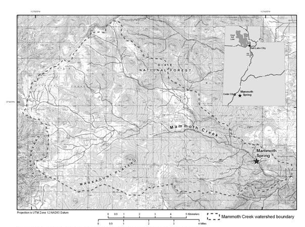
Figure 1. Location of Mammoth Spring on the Markagunt Plateau, southwestern Utah.
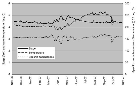
Figure 2. Relation between stage (discharge), water temperature, and specific conductance of Mammoth Spring.

![]() U.S. Department of the Interior |
U.S. Geological Survey
U.S. Department of the Interior |
U.S. Geological Survey
URL: http://pubsdata.usgs.gov/pubs/sir/2008/5023/14spangler.htm
Page Contact Information: Eve L. Kuniansky
Page Last Modified: Thursday, 10-Jan-2013 15:23:32 EST