USGS Scientific Investigations Report 2008-5023
<--Return to Contents
NATURAL RESOURCES AND KARST ECOSYSTEMS
By E.A. Raabe1 and E. Bialkowska-Jelinska2
1U.S. Geological Survey, 600 Fourth Street South, St. Petersburg, FL 33701
2Jacobs Technology, Inc., contractor for USGS, 600 Fourth Street South, St. Petersburg, FL 33701
Download PDF [1 MB].
Adobe Reader is required to view the report. A free copy of the Adobe Reader may be downloaded from Adobe Systems Incorporated.
Aquifer seeps along Florida's Gulf Coast were detected as temperature anomalies in airborne thermal infrared imagery. The coastal lowland is characterized by relatively flat terrain, near-surface and water-bearing limestone, sinkholes, and other surficial karst features (Crane, 1986; Rupert, 1988; Rupert, 1991). Several 1st and 2nd order springs are documented in the region (Suwannee River Water Management District, 2007). Anecdotes about aquifer seeps along the coast are common, but confirmation of their location and distribution has been lacking. This oral presentation describes the results of an analysis of temperature anomalies in the lower Suwannee River and nearby tidal creeks as derived from thermal infrared imagery acquired in late winter 2005 (VeriMap, 2005). Field reconnaissance and comparisons to other data sources confirmed the distribution of numerous seeps along the coast near Cedar Key, Florida (Fig. 1).
A key component to the analysis is the consistent temperature of the Floridan aquifer at approximately 22° Celsius year-round (Suwannee River Water Management District, 2007). During extended cold-winter or hot-summer weather, water temperature from the aquifer can contrast sharply with that of surrounding surface waters (Siegel et al., 1996; Spechler, 1996). Airborne acquisition of thermal imagery during a winter-cold spell made it possible to generate maps of multiple aquifer-discharge locations and their associated thermal plumes. Nighttime thermal infrared-image acquisition eliminated the possibility of false positives such as solar-heated sand. Water features exceeding ambient temperatures by 4° Celsius or more were mapped as "hot spots." Thermal plumes from these features were mapped when they exceeded ambient water temperature by 1° Celsius or more. Field reconnaissance confirmed temperature anomalies, small boils, and a variety of discharge-location characteristics. Full methodology and results were published by Raabe and Bialkowska-Jelinska (2007).
Identified "hot spots" included linear sections of tidal creeks, "tadpole-shaped" features leading into tidal creeks, sinkholes within the coastal forest, and thermal plumes associated with temperature anomalies (Fig. 1). Mobile species, such as manatee and sturgeon, use seep locations as thermal refugia during cold winter weather (Carr et al., 1996; Packard and Wetterquist, 1986). Local plant communities can indicate distinct water quality and discharge characteristics. Additionally, the discharge associated with these submarine features can play an important role in estuarine water quality (Katz et al., 1999; Katz and Raabe, 2005). Comparison of these features with existing data sources such as habitat maps, historic change analysis, satellite thermal imagery, and biomass fluctuation reveal unique habitat characteristics at coastal-aquifer exit points in the coastal ecosystem. The application of thermal infrared imagery in mapping the distribution of coastal-aquifer seeps shows promise in visualizing underlying karst, fracture zones, and underground conduits.
Carr, S.H., Tatman, F., and Chapman, F.A., 1996, Observation on the natural history of the Gulf of Mexico sturgeon (Acipenser oxyrinchus de sotoi Vladykov 1955) in the Suwannee River, southeastern United States: Ecology of Freshwater Fish, v. 5, no. 4, 169p.
Crane, J.J., 1986, An investigation of the geology, hydrogeology, and hydrochemistry of the Lower Suwannee River basin: Florida Geological Survey Investigation Report 96: 110.
Katz, B.G., Hornsby, H.D. Bohlke, J.F., and Mokray, M.F., 1999, Sources and Chronology of Nitrate Contamination in Spring Waters, Suwannee River Basin, Florida: U.S. Geological Survey Water-Resources Investigations Report 99-4252: 54.
Katz, B.G., and Raabe, E.A., 2005, Suwannee River Basin and Estuary: Integrated Watershed Science Program: U.S. Geological Survey Open-File Report; 2005-1210: 20. http://gulfsci.usgs.gov/suwannee/reports/index.html
Packard, J.M. and Wetterquist, O.F., 1986, Evaluation of Manatee Habitat Systems on the Northwestern Florida Coast: Coastal Zone Management Journal, v. 14, no. 4, p. 279-310.
Raabe, E.A. and Bialkowska-Jelinska, E., 2007, Temperature Anomalies in the Lower Suwannee River and Tidal Creeks, Florida, 2005: U.S. Geological Survey Open-File Report 2007-1311. http://pubs.usgs.gov/of/2007/1311/
Rupert, F.R., 1988, Geology and geomorphology of Levy County, Florida: U.S. Geological Survey Open-File Report, no. 19, 18p.
Rupert, F.R., 1991, Geology and geomorphology of Dixie County, Florida: U.S Geological Survey Open-File Report, no. 45, 6p.
Siegel, E.M., Weisberg, R.H., Donovan, J.C., and Cole, R.D., 1996, Physical factors affecting intrusions in wetlands: the Suwannee River Estuary: University of South Florida, St. Petersburg, FL, Department of Marine Science, 127p.
Spechler, R.M., 1996, Detection and quality of previously undetermined Floridian aquifer system discharge to the St. Johns River, Jacksonville to Green Cove Springs, northeastern Florida: U.S. Geological Survey Water-Resources Investigations Report, 95-4257, 29p.
Suwannee River Water Management District, 2007, Technical Information about Springs. http://www.srwmd.state.fl.us/water+data/springs/technical+info.htm
Verimap, 2005, Fresh Water Seeps Project Overview: VeriMap PLUS Inc., 30p. http://www.verimap.com
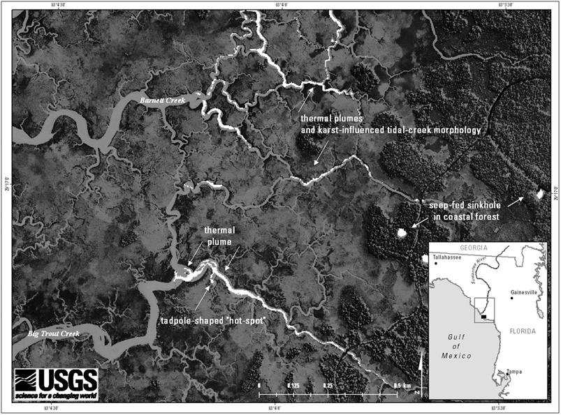
Figure 1. Tidal-creek temperature anomalies in nighttime thermal infrared imagery near Cedar Key, FL. Thermal plume direction reflects an incoming tide.

![]() U.S. Department of the Interior |
U.S. Geological Survey
U.S. Department of the Interior |
U.S. Geological Survey
URL: http://pubsdata.usgs.gov/pubs/sir/2008/5023/17raabe.htm
Page Contact Information: Eve L. Kuniansky
Page Last Modified: Thursday, 10-Jan-2013 15:23:35 EST