USGS Scientific Investigations Report 2008-5023
<--Return to Contents
MISCELLANEOUS TOPICS IN MODELING AND GEOPHYSICS
By Katarina Z. Doctor
George Mason University, katarina@doctor.com
Download PDF [173 kB].
Adobe Reader is required to view the report. A free copy of the Adobe Reader may be downloaded from Adobe Systems Incorporated.
Urban development is rapidly occurring in the karstic terrain of the Frederick Valley, Maryland, USA. Sinkholes are an inherent feature of the landscape; they present hazards and engineering challenges to the development of residential, commercial and industrial infrastructure. Here, a new approach is presented for assessing susceptibility of sinkhole occurrence. A sinkhole dataset and geologic map was obtained from the Maryland Geological Survey (Brezinski, 2004). Clustering and kernel density analyses were performed on the sinkhole location data to assess interdependence of sinkhole locations. External factors relating to sinkhole development were examined separately using Geographically Weighted Regression (GWR) and ordinary linear regression. These factors included geologic structure (folds axes and faults), rock type, proximity to impervious surfaces and surface drainage patterns. In order to determine the relative likelihood of sinkhole formation, the results of the cluster analysis, density analysis, and regression analyses resulted in map layers that could be weighted and overlain to create a sinkhole susceptibility map.
Cluster analysis is important for analyzing sinkhole development for two reasons: 1) human activities tend to fill an empty space by creating a more uniform pattern than random, 2) the eye tends to "see clusters where none exist" as the result of the mind's desire to organize spatial information (Rogerson, 2001). Nearest neighbor analysis (NNA) is the most common method of cluster analysis; however, this method will not capture a pattern that is non-homogeneous over a study area (Wong, 2005). The statistical method that is able to identify clustering in different scales is the K-function analysis, which compares the observed distribution of sinkholes to the same number of randomly distributed points. This method also considers the shape of the study region. In the Frederick Valley case study this was an important issue because of the elongated shape of the valley.
Sinkhole density is an important factor for determining the area most prone to sinkhole development. Where a closed depression has collapsed into a sinkhole we know that the underlying subsurface contains unstable voids, and possibly a cave system. In areas where active sinkholes have developed there is a greater possibility that a new sinkhole will form (Brezinski, 2004; Zhou, 2003). Two methods were used to determine sinkhole density. The first method is the Kernel Density Estimation (KDE) for which bandwidths were calculated with the previously described K-function analysis. The second method takes into account a radial buffer area around each sinkhole and is expressed as the number of sinkholes inside each buffer zone. As a result each sinkhole receives an attribute that is the density of sinkholes within its surrounding radial buffer zone. This result is used later for further calculations for estimating sinkhole susceptibility.
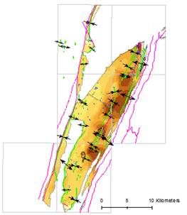
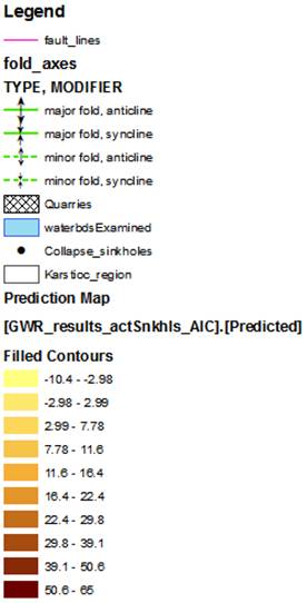
Several geologic and anthropogenic factors were identified in Frederick Valley that influence sinkhole development. These factors include proximity of sinkholes to quarries, water-bodies, fault lines, anticline and syncline fold axes, streams, roads and ground-water table depth (Zhou, 2003; Brezinki, 2004; Magdalene, 1995; Ordorff, 2000; Hack, 1965). The locations of these features are known from detailed geologic maps (Brezinski, 2004). Geographically Weighted Regression (GWR) analysis was used to express the significance of these factors in relation to sinkhole density. GWR is a multivariate regression which assumes that the relationship of weights of each influencing factor vary across space. From the GWR results, a map surface was produced for predicting highest sinkhole density using the Inverse Distance Weights method (Fig. 1).
These results may be a guide for future development activities in this region and others like it.
 |
 |
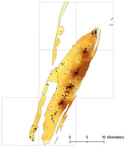 |
Figure 1. The top panel shows predicted sinkhole density and the actual sinkhole point locations. The bottom panel shows the predicted sinkhole density and some factors that influence sinkhole collapse.
Brezinski, D.K., 2004, Stratigraphy of the Frederick Valley and its Relationship to Karst, Rep. No. 75., Annapolis: Maryland Department of Natural Resources.
Hack, J.T., 1965, Gomorphology of the Shenandoah Valley, Virginia and West Virginia, and origin of the residual ore deposits: U.S. Geological Survey Professional Paper, 484 p.
Magdalene, S. and Alexander, E.C.Jr., 1995, Sinkhole Distribution in Winona County, Minnesota Revised. Proceedings of the Fifth Multidisciplinary Conference on Sinkholes and the Engineering and Environmental Impacts of Karst. Gatlinburg, Tennessee.
Ordorff, R.C. and Weary, D.J. and Lagueux, K.M., 2000, Geographic Information Systems analysis of Goloegic controls on the Distribution of Dolines in the Ozarks of South-Central Missouri, USA . Acta Carsologica, Vol. 29- No. 2, 11.
Rogerson, P.A., 2001, Statistical Methods for Geography, London, Sage Publications, 232 p.
Wong, D.W.S., and Lee, J., 2005, Statistical Analysis of Geographic Information with ArcView GIS and ArcGIS, Hoboken, New Jersey, John Wiley & Sons, Inc.
Zhou, W., Beck, B.F., and Adams, A.L., 2003, Application of Matrix Analysis in Delineating Sinkhole Risk Areas along Highway (I-70 near Fredrick, Maryland), Environmental Geology, No. 44, pg. 834-842.

![]() U.S. Department of the Interior |
U.S. Geological Survey
U.S. Department of the Interior |
U.S. Geological Survey
URL: http://pubsdata.usgs.gov/pubs/sir/2008/5023/39doctor.htm
Page Contact Information: Eve L. Kuniansky
Page Last Modified: Thursday, 10-Jan-2013 15:23:55 EST