USGS Scientific Investigations Report 2008-5023
<--Return to Contents
FIELD TRIP GUIDES
Field Trip Led By Rickard S. Toomey, III1 and Rick Olson2
1Mammoth Cave International Center for Science and Learning, 1906 College Heights Blvd #31066, Bowling Green, KY 42101-1066
2Mammoth
Cave
National Park,
P.O. Box 7,
Mammoth Cave,
KY
42259
Download PDF [6.15 MB].
Adobe Reader is required to view the report. A free copy of the Adobe Reader may be downloaded from Adobe Systems Incorporated.
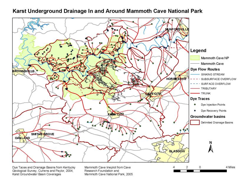
The materials provided for this field guide come from brochures and briefing papers that are used as handouts at Mammoth Cave National Park. Sections are authored by different individuals or organizations. Numerous tracer tests have been conducted in and around the park to help determine the underground drainage basins and a map is provided by the Cave Research Foundation. Arthur N. Palmer developed a brochure on the Geology of the Mammoth Cave Area and Guide to the Historic Route of Mammoth Cave. Rick Olson, the Park Ecologist, developed a briefing paper on Biospeleology of Mammoth Cave. All material reprinted in this proceedings obtained by permission from the authors and from the U.S. Department of the Interior, National Park Service, Mammoth Cave National Park.
Beneath the surface of south-central Kentucky lays a world characterized by miles of dark, seemingly endless passageways. The geological processes which formed this world referred to as Mammoth Cave began hundreds of millions of years ago and continue today. (Photo and caption from U.S. Department of the Interior, National Park Service Mammoth Cave National Park, Karst Geology Brochure).
By Arthur N. Palmer
Reprinted with permission of the author and Mammoth Cave National Park
Mammoth Cave is the longest known cave in the world, with about 350 miles of interconnected passages known today. Exploration and mapping continue, and there is no end in sight. The cave consists of several large sections explored separately through various entrances and connected by later discoveries (Figure 1). It is located mainly within Mammoth Cave National Park, established in 1941 and administered by the National Park Service. The Park was designated a World Heritage Site in 1981 on the basis of its geological, archaeological, and biological significance, and it was designated an International Biosphere Reserve in 1990. About 9 miles of trails in the cave are open to the public on a variety of guided tours.
A landscape that is dominated by solutional features such as sinkholes, sinking streams, caves, and large springs is known as karst. This name comes from a plateau in western Slovenia (south of Austria ) where some of the earliest studies of these features were made. Figure 2 shows the extent of karst regions and volcanic caves in the USA.
The cave is located in a low plateau of limestone, a rock that dissolves readily in most natural water. The great majority of caves are formed by the dissolving action of underground water as it seeps through the cracks in limestone. This particular limestone was originally deposited on the floor of a shallow sea that covered this part of the continent about 330-340 million years ago. At Mammoth Cave the limestone is capped by insoluble rocks, mainly sandstone, which form a resistant cap over the cavernous rocks below. This cap-rock helps to protect the upper-level passages in the cave from being eroded away. The rock layers are tilted an average of about 0.3 degrees toward the northwest (Figure 3).
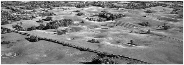
The sandstone-capped region is called the Chester Upland (Figure 4). It rises to about 800 ft above sea level. Stream erosion has carved valleys into the caprock in many places, leaving irregular flat-topped ridges between them. To the south and east, where the caprock has been completely eroded away, the limestone is exposed in a broad and nearly flat plateau, called the Pennyroyal Plateau (Figure 5), which lies about 150-200 ft below the ridge crests of the Chester Upland. It too is underlain by many caves, and its surface is dimpled with thousands of sinkholes. Sinkholes are depressions formed by solution of the limestone by descending water and collapse of the limestone into underlying caves. All explored passages of the Mammoth Cave System lie in the Chester Upland, but dye-tracing of underground water shows that many of the cave streams in the cave are fed by sinking streams and sinkholes in the Pennyroyal Plateau.
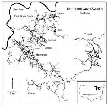
Figure 1: Map of Mammoth Cave, showing the various sections of the cave that were explored independently and connected by later discoveries. From map by Cave Research Foundation and Central Kentucky Karst Coalition.
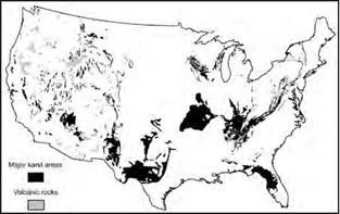
Figure 2: Map of "Lower 48" States showing areas of karst (including solution caves) and also caves in volcanic rock.
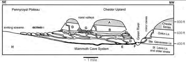
Figure 3: Simplified profile through Mammoth Cave, showing passage relationships, elevations, landscape types, and relation to rock layers. A=sandstone caprock; B=upper levels, partly sediment-filled; C, D = lower levels; E= presently active stream passages; F=springs; G=stream valley cut into Chester Upland, now drained through sinkholes in its bottom; H = poorly soluble limestones that support surface streams.
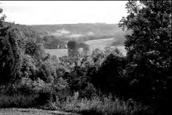
Figure 4: Scene in the Chester Upland, where a dry karst valley has dissected the sandstone-capped ridges.
Water in Mammoth Cave drains through springs into the Green River, which is one of the few permanent surface rivers in the region. During its travels through the limestone, the water is able to form long passageways that join and branch in a very complex array. In most rocks, groundwater flows in a diffuse manner through tiny pores and cracks. Even in limestone, this is the case at first. But with time, the groundwater paths with the greatest amount of flow enlarge the cracks into large tunnels, such as those in Mammoth Cave. The flow of a cave stream can be as fast as any surface stream. The water surrounding the caves is still slow-moving and diffuse. Most of the limestone actually contains this kind of water, and this is the water that feeds most water wells. If a well encounters an active cave stream, there is usually plenty of water, but the water quality may be limited. The rapid flow of water, and the lack of filtering, allow contaminants to travel easily through cave passages. For that reason, most springs in cave regions are not reliable water sources.
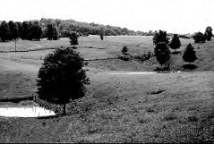
Figure 5: Scene in the Pennyroyal Plateau. Note the many sinkholes, some of which contain ponded water.
Passages in the cave have formed not only by water from sinkholes in the Pennyroyal Plateau, but also from stream valleys in the Chester Upland (Figure 3). Much of the water in these valleys enters along the eroded edge of the sandstone cap to form small tributary passages. Most passages n Mammoth Cave have been abandoned by their treams. As the Green River valley deepens by erosion, older passages lose their water to lower routes, which form new passages, while the older ones are left high and dry.
The cave extends through several major lime-in Mammoth Cave have been abandoned by their stone units: the Girkin Formation, Ste. Genevieve streams. As the Green River valley deepens by Limestone, and St. Louis Limestone (Figures 3, erosion, older passages lose their water to lower 6, 7). Limestone consists of calcium carbonate, which includes small fragments of fossils that have been broken apart by wave action and cemented together by additional calcium carbonate. Each limestone has slightly different characteristics. The Girkin Formation contains thick lime-stone beds interspersed with thin, soft, shaly beds that recess inward in cave walls. The Ste. Genevieve contains a broad variety of mainly thin-bedded limestones and dolomites (a magnesium rich variant of limestone). The St. Louis contains many beds of chert (flint), which project from the cave walls. All three limestone units can be subdivided into many thinner beds (Figure 7), and by recognizing these in the cave, it is possible to tell one’s position relative to the bottom of the caprock.
Mammoth Cave contains several types of passages. Above the water table (the level below which water fills all openings in the rock), the typical passages are narrow and canyon-like (Figure 8). They are higher than they are wide, with curving, sinuous paths. These passages form where the water drains along the bedding (layering) of the rock, generally in the direction of local dip (tilt) of the beds. Their sinuosity is caused by irregularities in the local direction of tilt. Canyons in Mammoth Cave range up to 10-30 feet wide and up to 80-100 feet high, but most are much narrower and not so high. Where water is able to descend more or less vertically along fractures, vertical shafts are formed (Figure 9). Shafts are generally round or oval in horizontal cross section and nearly all have developed in stages by periodic downward dissolution from bed to bed. Most shafts show a sequence of drains at various elevations in their walls. Water descending a shaft today of course exits by the lowest drain, which is located at the shaft floor. The largest shafts in Mammoth Cave range up to 150 feet deep and several tens of feet in diameter. Above the water table, water descends along the steepest available paths through the limestone. Most of the resulting passages are canyons interrupted in places along their length by shafts, to form descending stair-step profiles.
Below the water table, water follows the most efficient paths to the nearest surface outlet (such as the Green River). The caves transmit water so easily that the water table in them is almost equivalent to the Green River level. Most passages that form below the water table have tubular shapes with rounded cross sections and very gentle slopes (Figure 10). Tubes tend to be sinuous, like canyon passages or surface rivers. Although most of them form at or just below the water table, some extend well below the water table and rise back up farther downstream.
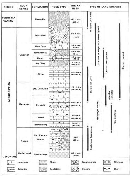
Figure 6: Rock layers in the Mammoth Cave region, and their relation to landscape types.
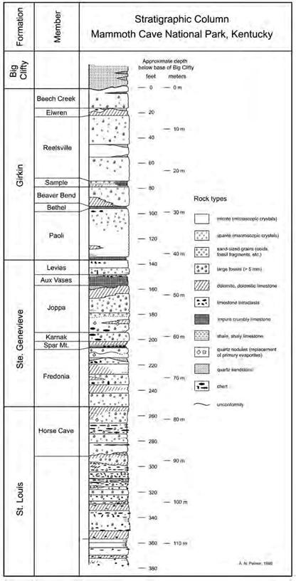
Figure 7: Details of the rock sequence exposed in Mammoth Cave.
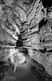
Figure 8: A typical canyon passage in Mammoth Cave (Pass of El Ghor, near the Grand Avenue Tour in Mammoth Cave).
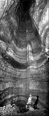
Figure 9: A typical shaft formed by descending water (Edna's Dome, on the Wild Cave Tour).
Also formed below the water table are passages that follow prominent fractures.These are straight, narrow, and fissure-like. Many solutionally enlarged fractures can be seen in passage ceilings here and there in Mammoth Cave, but there are only a few small passages of this type that can actually be followed.
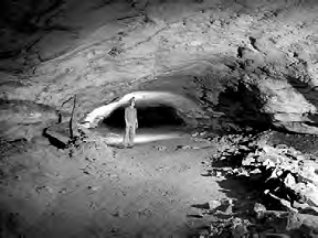
Figure 10: A typical tubular cave passage formed at or below the water table. This is Pensico Avenue, just off the Historic Route, at the 550-foot level.
Passages in Mammoth Cave occupy a vertical range of about 350 feet. Canyons can form anywhere above the water table, and roughly half of them are still active today. But tubular passages cluster at only a few elevations, which correspond to significant pauses in deepening of the Green River valley. These elevations are most easily recognized by places where canyon passages (formed above the water table) change downstream to tubular passages (formed at or below the water table). Today these points cluster at about 500, 550, 600, and 690 feet above sea level (Figure 3). They provide clues to the drainage history of the major rivers of the region, including the Ohio River and its tributaries, the Green River being one of them.
It is difficult to determine when a cave passage formed. First of all, the passage enlarges over many tens of thousands of years (and probably more), so there is no distinct birth date. Second, what is left to measure? One way of determining when the latest enlargement took place is to analyze the sand and gravel sediment that is left in most passages by the underground streams. By measuring tiny amounts of radioactive materials in the rocks, it is possible to tell how long ago the sediment was carried underground into the cave. While the sediment is at the surface, radioactive aluminum and beryllium are produced in tiny quantities by cosmic radiation. When the sediment is carried underground, these radioactive materials are no longer produced, and they gradually decay. The aluminum and beryllium decay at different rates, and their ratio indicates how long they have been underground. The technique works well, with a small amount of scatter, for ages up to 5 million years.
The two upper levels (above 550 ft) are wide canyons and tubes filled to various depths with stream-borne quartz silt, sand, and gravel (Figure 11). Some are completely filled. In a few passages at these levels, most of sediment has been removed by stream erosion. The greatest sediment thickness is about 70 ft. Passages at these levels have sediment dates of 2.5-4 million years, and of course the passages are older still. These passages represent slow cave development, alternating with sediment accumulation, when rivers were fairly stable, with very slow erosion interrupted periodically by sediment filling (probably when the climate was relatively dry). The rather flat surface of the Pennyroyal Plateau formed at this time. It is located at the same elevations as the upper-level passages in the cave.
About 2.5 million years ago there was widespread accumulation of sediment with thicknesses as much as 100 ft. It filled all upper-level passages, some partially and others completely, and also covered the Pennyroyal surface. This event took place at about the same time as the first major advances of glaciers in North America.
In the lower cave levels the passages are smaller in cross section (as in Figure 10), partly because groundwater recharge had become fragmented into many sub-basins by that time, and also because pauses in base level were shorter. Prior to this time, karst was probably sparse on the Pennyroyal because of limited entrenchment. The rapid drop in base level during the past 2 million years has caused nearly all surface drainage on the Pennyroyal to be diverted underground, and the extensive sinkhole-pocked surface of today began to form (Figure 5). Cave levels at 550 and 500 ft are well-developed tubes with little sediment fill. Sediments at these levels are respectively about 1.5 and 1.2 million years old. Passages at other elevations are mainly shafts, small canyons, and crawlways, mostly formed above the water table. Many are still active today as water drains from the overlying land surface (Figure 12). Some large tubes have formed below the 500 ft level, but their elevations are not consistent. They include local tube segments fed by many small tributaries, as well as passages perched on relatively insoluble beds.
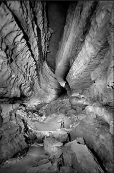
Figure 11: Collins Avenue, in the Crystal Cave section of Mammoth Cave, is the highest and oldest passage level in the cave. Typical of all high-level passages, it was nearly filled with sediment about 2.5 million years ago. Most of the sediment has been removed at this point by later erosion by a cave stream, exposing the full 70-foot height of the canyon.
The sudden abandonment of the large upper-level passages and development of many small passages at lower levels apparently resulted from major changes in the patterns of surface drainage. Until the beginning of glacial advances, the Ohio River was rather small, not significantly larger than the Green River. Most of the drainage from the east followed more northerly routes, which first drained northward, toward where the St. Lawrence River is today. Later it diverted into the Mississippi River through northern Indiana and Illinois (the so-called “Teays River”). The first major glacial advances into the region blocked these older routes and diverted their flow into the Ohio. Suddenly the Ohio became the largest river in the eastern US. It began to deepen its valley rapidly, and the Green River, a tributary of the Ohio, did the same. Diversion of water to form the Teays River took place about 1.5 million years ago, accounting for the rapid entrenchment below the upper two cave levels. Diversion of the Teays to form the present Ohio River took place about a million years ago. These are the most recent sediment dates for the passages at 550 and 500 feet and represent the times just before the passages were abandoned.
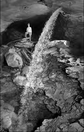
Figure 12: A waterfall in the Flint Ridge section of Mammoth Cave is fed by an overlying canyon. Here it intersects an older tube and continues into another canyon at a lower level.
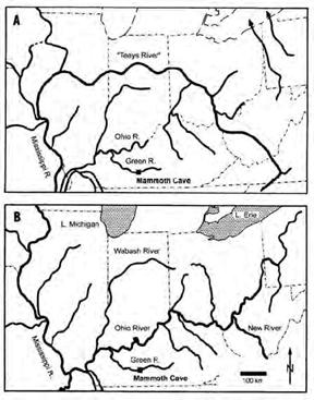
Figure 13: Development of the Ohio River drainage over the past 2 million years. Originally the drainage from the northeastern U.S. went northward (1), then diverted to the Mississippi as the "Teays River" (2). Eventually it was diverted by glacial ice into the Ohio River, which was formerly fairly small. The uppermost passages in Mammoth Cave formed during stage 1, and the lower levels formed during stages 2 and 3.
Mineral deposits in Mammoth Cave are highly varied. Stalactites, stalagmites, and flowstone (made of the mineral calcite, the same as the limestone bedrock) are somewhat rare because the rather impermeable caprock limits the amount of water seepage into the cave. But minerals that form by evaporation, such as gypsum (a calcium sulfate mineral) are abundant in dry passages (Figure 14).
The astonishing length of Mammoth Cave is the result of from several factors: Its drainage basin is large, about 100 square miles. Prominent layering in the rock allows water to divert along many successively lower routes. The resistant caprock has protected many of the uppermost passages from erosional destruction. Finally, the many small but discrete changes in base level have allowed the development of many rather independent cave levels.
Mammoth Cave is also of great archeological, biological, and historical interest. As early as 4000 years ago native humans ranged through many miles of the cave on a quest for minerals or adventure, using only reed torches for light. Artifacts and several mummified bodies have been discovered in the cave. Cave biota include the rare Kentucky cave shrimp and eyeless fish. Sediment in the main passage of Mammoth Cave was mined for nitrates to make gunpowder during the War of 1812. Since then the cave has been more or less continually open to the public, first by a series of private owners, and later by the National Park Service.
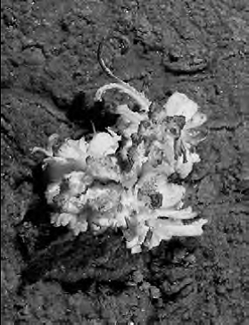
Figure 14: A gypsum “flower” in Mammoth Cave, formed by evaporation of water from the cave ceiling, which allowed hydrated calcium sulfate (gypsum) to precipitate from the moisture.
Granger, D.E., Fabel, D. & Palmer, A.N. 2001. Pliocene-Pleistocene incision of the Green River, 26Al and 10Be in Mammoth Cave sediments. Geological Society of America Bulletin, 113(7): 825-836.
Palmer, A.N. 1981. A Geological Guide to Mammoth Cave National Park. Teaneck, N.J.: Zephyrus Press.
Palmer, A.N. 1989. Geomorphic history of the Mammoth Cave System. In: Karst Hydrology: Concepts from the Mammoth , edited by W.B. White & E.L. White, New York: Van Nostrand Reinhold.
Pohl, E.R. 1970. Upper Mississippian deposits of south-central Kentucky. Kentucky Academy of Science Transactions, 31: 1-15.
White, W.B. & White, E.L. (editors) 1989. Karst Hydrology - Concepts from the Mammoth Cave Area. New York: Van Nostrand Reinhold.
White, W.B., Watson, R,A., Pohl, E.R. & Brucker, R.W. 1970. The central Kentucky karst, Geographical Review, 60: 88-115.
By Arthur N. Palmer
Reprinted with permission of the author and Mammoth Cave National Park
Of all the tours in Mammoth Cave, this one gives the best view of the various rock layers and passage levels. It also emphasizes the historical aspects of the cave, particularly its exploration, saltpeter mining, and archeology. Remnants of a saltpeter mining operation of the early 1800s are still preserved in the cave. These include wooden vats for leaching saltpeter from the cave sediment, and an impressive system of hollow wooden pipes for conveying water to and from the leaching vats. There are several exhibits of prehistoric Indian artifacts that have been found in the cave.
A map of the passages on the Historic Tour is shown in Figure 15. The tour begins at the Historic Entrance, the only natural opening to Mammoth Cave. This entrance was formed when a tributary valley of the Green River cut into one of the main cave passages. The entrance descends steeply through the Beaver Bend Member of the Girkin Formation and leads to the main level of the cave (level B on Figure 3) at an altitude of 600 feet (180 m). A short passage in the Paoli Member (Houchins' Narrows, labeled #1 on the map) leads to an impressive junction called the Rotunda (#2). The 19th century saltpeter leaching vats and water pipes are located in this part of the cave. Three passages branch from the Rotunda (Houchins' Narrows, Broadway, and Audubon Avenue), all at the same level. [Note: In this area, beds in the upper half of the column are locally about half as thick as shown in Figure 7, and most of those below are about twice as thick.] In what direction did the water flow when they were being formed? Most of the clues to flow directions are absent. These large passages are only the upper third of canyons that were once as much as 80 feet (25 m) deep and that were partially filled by sediment and modified by breakdown. From the passage directions, it looks as though both Audubon Avenue and Houchin’s Narrows were probably fed by Broadway and drained out of the Rotunda to the Green River. Audubon Avenue leads to the right for approximately 1000 feet (300 m) and ends in breakdown at the edge of the Green River valley. It is unlikely that both Houchins’ Narrows and Audubon Avenue formed at the same time by branching of the main cave stream. Probably Houchins’ Narrows, the smallest of the three passages, formed later than Audubon Avenue as a diversion route for the underground water.
Here is a good chance to look at how the different kinds of limestone affect the cave. The medium-bedded Paoli Member occupies nearly the entire height of the Rotunda. It consists of 21 feet (6.4 m) of finely crystalline dolomitic limestone. Near the ceiling is an irregular, recessed ledge formed by the Bethel Member, a shaly and relatively weak limestone only a few feet thick. The base of the Paoli (unit P1), a granular, silty limestone, is even less resistant and forms a sharply recessed niche of crumbly, dark-gray rock a few feet above the floor of the passages in this area.
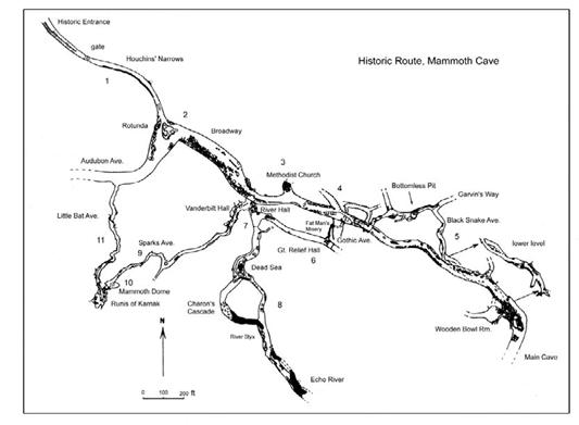
Figure 15: Map of the Historic Route of Mammoth Cave. The numbers refer to various features of interest described in this trail guide.
The tour proceeds through Broadway in what was originally the upstream direction for the underground water (Figure 16). Here the sediment has been partly removed through lower-level passages by stream action, so the floor descends into the Ste. Genevieve Limestone as far as the Joppa Member, while the ceiling remains at the same level as in the Rotunda. Some sediment has also been moved around by saltpeter miners.
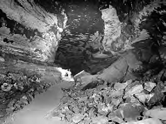
Figure 16: Part of the Main Cave beyond the Historic Route (see Figure 15). This is the upstream end of Broadway (more specifically, the lower half of Broadway).
At point #3, at the "Methodist Church," about 1000 feet (300 m) beyond the Rotunda, the passage branches into two separate levels, each only half as high as Broadway. The upper level disappears into a pile of breakdown (collapse material), and the lower one continues straight ahead as the "Main Cave."
What is the relationship between the two levels? Continuing on to point #4, we see the upper level come in again, cross over the Main Cave, and disappear in the former upstream direction as Gothic Avenue, a tube about 15-20 feet (4.66 m) high. The great ceiling height of Broadway represents the combined height of the two branches.
The trail continues through the Main Cave for a short distance to the Giant's Coffin, an enormous breakdown block. It then exits to the right through a narrow canyon (Dante's Gateway), which once drained water from the Main Cave to the lower levels. The canyon descends through the light-gray Joppa and Karnak Members to the Wooden Bowl Room. Named for one of the prehistoric Indian artifacts found here, the Wooden Bowl Room is located at level C, (550 feet = 168 m; see Figure 3) where several passages intersect one another. The thick-bedded Karnak Member forms the flat ceiling of this wide, low room.
A steep descent through the upper Fredonia Member leads to the tour's first tubular passage, a lower loop of level C called Black Snake Avenue (location #5 on the map; see Figure 17). This passage is located in the thick, crystalline F3 unit. In this part of the cave the F3 unit contains a yellow dolomite bed, which forms the smooth passage floor.
At one point there are fissures extending into the ceiling. Many geologists consider such features to have formed when water descending through the fissure mixed with water in Black Snake Avenue. Groundwater is able to dissolve more limestone if it has a high level of carbon dioxide. Most carbon dioxide is contributed by the soil as the water seeps through it. The mixture of two saturated solutions having different carbon dioxide contents can produce an undersaturated solution capable of dissolving more limestone.
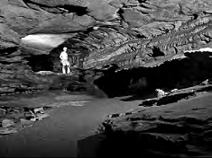
Figure 17: Black Snake Avenue, a tube at level C. This is the upstream end of Pensico Avenue, shown in Figure 10. Here it occupies two closely spaced tiers.
Is this a feasible explanation for the ceiling fissures? What are a few flaws in this argument? It is more likely that the fissures were formed by periodic flooding, back when the passage was at or near the water table. Each flood would deliver water rapidly from the surface, water that was highly capable of dissolving limestone. Filling of the passage under hydraulic pressure would force this aggressive water into all cracks in the surrounding cave walls and ceilings, enlarging the cracks into fissures. The water would then drain out as the flood subsided.
Just beyond the fissures, the contacts between several limestone beds have been dissolved inward into the passage walls to form a tiny maze of tubes. Below these tubes the walls are deeply grooved by water that apparently flowed out of the tubes. Do these features clarify the origin of the fissures in the ceiling?
Note the excellent solutional hollows (scallops) in the nearby floors of the passage. The direction of flow is shown by their asymmetry (as in sand dunes). The steep side of each hollow is on the former upstream side. Our tour is moving in the direction of former flow. Also, the average length of the scallops can be used to estimate the former flow velocity. Measure the average length of the well-developed scallops in centimeters and divide that number into 275 to get the former flow velocity in centimeters per second. For example, scallops 5 cm in length would indicate a local flow velocity of about 55 cm/sec. Obviously this is approximate, because the flow velocities vary with time. These probably represent the high-flow velocities that last enlarged the passage.
Black Snake Avenue passes beneath the Main Cave and extends along the northeastern edge of Mammoth Cave Ridge, where a great deal of water enters from the nearby limestone-floored valley. This water forms many impressive vertical shafts that intersect the otherwise dry passages in this part of the cave. While the tubes at this level were forming, they lay close to the level of the Green river, but they are now located far above the river. Water drains from the surface through narrow canyons into the tops of vertical shafts and flows out through the shaft drains to the lowest and still active passages near the level of the Green River.
A typical shaft is Bottomless Pit, which yawns to a depth of about 100 feet (30 m) below the level of the trail and rises 60 feet (18 m) above. A bridge now spans the chasm, but before this addition, in order to pass this point, early explorers were treated to the unforgettable experience of crawling around the pit on a narrow ledge.
The tube continues as Pensico Avenue, but the tour follows a branch to the left and descends a short flight of stairs through an opening called Scotchman's Trap. This opening leads to several low, wide passages in the dolomitic limestone of unit F2, at level D (500 feet = 152 m). The trail branches into a narrow canyon called Fat Man's Misery. This passage is shaped like a keyhole, wide at the top but quickly narrowing to little more than a foot toward the floor. It is too low to walk through without stooping. Although it is not tight by explorers' standards, this is as close a view of the limestone as most visitors wish.
Just as Fat Man's Misery looks as though it is going to pinch down to an impasse, it opens into a spacious tubular passage called Great Relief Hall (location #6 on map). This originally received its name from the relief that visitors presumably felt when emerging from the narrow canyon. Its name took on a new meaning when restrooms were installed in the Hall.
Great Relief Hall is also at level D (Figure 17). The ceiling is formed by the base of the thick-bedded, coarse-grained unit F3. Here the rock contains many joints enlarged upward by solution, as well as irregular chert nodules that protrude downward from the ceiling because they are so resistant to solution. The lower walls of this passage have a moth-eaten appearance caused by solution pockets in a dolomite bed in unit F2. This distinctive rock unit is seen at two other places on this tour. Can you spot them?
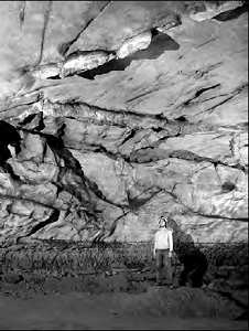
Figure 17: Great Relief Hall, at an elevation of 500 feet, is a typical tube at level D. In the ceiling, note the solutionally enlarged fissures and the "dikes" of resistant chert (flint) protruding from the limestone. Near the floor is a bed of dolomite that has a distinctive pock-marked texture.
The tubular passage descends about 20-30 feet into River Hall (location #7). This descent was originally part of a loop that the passage took below the water table. It is still level D, and drained to a former spring at the 500-foot elevation; but here its elevation is about 470 feet (143 m). The contact between the Ste. Genevieve Limestone and the underlying St. Louis Limestone is not very distinct in the Mammoth Cave area. It appears as a prominent contact between beds at the level of several old bowl-shaped electric lights. The upper St. Louis does not contain the bedded chert that is so typical lower down in the formation.
The opening at the lower end of River Hall leads to River Styx and Echo River, which are parts of one of the largest stream passages in the cave. These river passages are located at the same level as the present-day Green River (about 425 ft = 130 m above sea level).
Large scallops in the ceiling of River Hall indicate that the original water flow came from River Styx, joined the water from Great Relief Hall, and continued straight ahead in a passage now blocked with breakdown.
The passages at river level therefore developed at the same time as River Hall, which is the same age as Great Relief Hall. Together, these passages span a vertical range of 75 feet (23 m), and yet they all formed when the Green River was at 500 feet. River Hall, River Styx, and Echo River formed below the water table simply because those particular routes were most efficient at transmitting water.
Our tour descends into River Styx. This is the largest passage we have seen since leaving the Main Cave. No wonder it is large --it is still actively enlarging today, and has continued to do so since level D began to form more than a million years ago.
Those who think this explanation is too idealistic should follow the River Styx passage upstream to Echo River and beyond (Figure 18). The passage begins to climb in the upstream direction, still as a tube, but then as it passes above an elevation of 500 feet it changes to a canyon passage. Part of the canyon is shown in Figure 8. This was the former water table when the river passages first started to form.
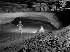
Figure 18: The upstream end of Echo River is at exactly the same elevation as the present Green River and is nearly filled with water and sediment.
We return to River Hall and exit through an upper-level passage. On the way out, note the brass markers that indicate levels of recent floods. This entire part of the cave fills with water every couple of decades.
Soon the walls and ceiling draw near and the tour enters Sparks Avenue, a wide, low tube along the Ste. Genevieve/St. Louis contact (location #9 on map). The walls are obscured nearly everywhere by banks of sand and gravel deposited by the stream that once flowed through this passage. The gravel consists of white quartz pebbles weathered out of the Caseyville Formation that once capped Mammoth Cave Ridge (see Figure 6). These pebbles have been instrumental in helping to date the ages of the various cave levels (see page 6).
Large, fissure-like solution pockets occur here and there in the ceiling along joints in the thick-bedded F1 unit. At Leopard's Arch the passage rises abruptly into the F1 unit along a joint, a rare occurrence in Mammoth Cave. Sand on the floor contains cross beds that indicate water movement in the direction we are traveling. So the water that deposited the sand must have flowed upward at the point where the passage jogs into the F1 unit (Figure 19). Wall scallops also show this direction of flow, although their directions are complicated by the many back-eddies that occurred at the sharp bends in the passage.
Sparks Avenue opens into the impressive Mammoth Dome (location #10). This is one of the largest vertical shafts in the cave. It is about 190 feet (58 m) high and extends from the Beaver bend Member of the Girkin Formation through the entire Ste. Genevieve Limestone, and 29 feet (8.8 m) into the St. Louis. Water descends from the top of the shaft as a spray and filters into rocks that choke the bottom of the shaft. This water probably comes from a sinkhole located almost directly above. Several canyons open from the south wall of Mammoth Dome, and it is possible to see, by peering straight up through a haze of descending water drops, a narrow, wiggly canyon at the very top of the dome. The contact between the Ste. Genevieve and the St. Louis can be clearly seen 7 feet (2.1 m) below the floor of the lowest balcony in Mammoth Dome.
A metal staircase leads almost to the top of the dome, giving a spectacular view of almost the entire Ste. Genevieve Limestone. Here the F3 is essentially a single massive bed of crystalline gray limestone. Looming to the left are the Ruins of Karnak, which are monolithic pillars of the Fredonia Member sculpted by descending water.
The flat ceiling above is the base of the thick-bedded Karnak Member. (Early explorers were fond of drawing from antiquity and mythology for their names of cave features. The Ruins of Karnak are named for the ancient ruins near the village of Karnak on the banks of the Nile River. However, except in name, the Ruins of Karnak have no direct connection with the Karnak Member, which was named for the little town of Karnak in southern Illinois.)
The tour climbs to a final overlook of Mammoth Dome, then doubles back into Little Bat Avenue. This is a tube at level B, which at one time drained water from Audubon Avenue. Little Bat Avenue is located along the contact between the Aux Vases and Joppa Members. The tube suddenly opens into the enormous void of Audubon Avenue, which leads a short distance to the Rotunda. Having completed a long, intricate loop, the tour exits through the Historic Entrance.
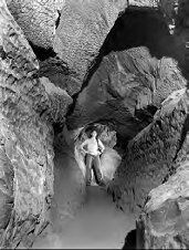
Figure 19: Leopard's Arch is a fissure in Sparks Avenue that rises in the downstream direction. Like a hose, water filled it and rose under pressure. The direction of flow is indicated by scallops and by cross-beds in nearby floor sediment (like those in sand dunes).
By Rick Olson, Park Ecologist, Mammoth Cave National Park 2003, all photos by author reprinted by permission.
In order to understand the biospeleology of Mammoth Cave, it must be viewed in context of the South-Central Kentucky Karst where there are two historical and four functioning ecosystems. In pre-settlement times, prairie and savanna maintained by fire were prevalent. These ecosystems were converted to agriculture over the past two centuries, but forest, river, and cave ecosystems are relatively intact. Mammoth Cave biota are among the most diverse in the world (Culver et al. 1999), with approximately 130 regularly occurring species roughly divided between troglobites, trolophiles, and trogloxenes (Barr, 1967 Poulson 1992, 1993). Troglobites are fully cave adapted, and cannot survive in surface habitats. Aquatic troglobites are also referred to as stygobites. Troglophiles are species that can complete their life cycle in both cave and surface habitats, and trogloxenes use caves for refuge or may come in to prey upon other species.
Functionally, since sinking streams and cave streams are tributaries of base-level rivers by way of springs, they are all part of the river continuum, with the important distinction that the middle section is underground. These distinct but connected aquatic ecosystems are energetically supported by in-washed organic debris from the forest and former prairie/savanna ecosystems. Food transport is usually down gradient, but natural back flooding from the river into cave streams is also important.
Cave aquatic habitats can be roughly divided on the basis of water quantity. Ephemeral pools occur in rimstone dams, near terminal breakdowns, in passages rarely flooded, and shafts. These may feed nearby shallow streams tributary to master shaft drains grading into base level streams, which feed springs on the Green River. As the river lowers its channel, cave streams follow and leave dry upper levels.
These upper levels are habitat for the terrestrial cave ecosystem, also dependent upon forest and agricultural land for food. The import of food is mostly accomplished by cave crickets and to a lesser degree woodrats and bats, which feed in the forest, and use caves for refuge where guano accumulates. Crickets also lay eggs in caves, which support a separate community. Raccoons, entering caves to feed on bats and cave crickets, may leave significant quantities of scat. Habitats here are determined by proximity to entrances with variable temperature and humidity, which in turn determines the species leaving guano. Leaf litter falling into entrances, and flood debris deposited on passage surfaces are also locally important to the terrestrial cave ecosystem.
One prevalent aspect of aquatic life in the Mammoth Cave System is habitat partitioning by similar species within a taxonomic group. Two troglobitic species each of planaria (Sphalloplana percocea and S. buchanani), amphipods (Stygobromus vitreus and S. excilis), isopods (Caecidotea stygia and C. bicrenata), and fish (Typhlichthys subterraneus and Amblyopsis spelaea) occupy upstream and downstream habitats respectively. Troglobites found only in base level streams include a snail (Antroselates spiralis), and the endangered Kentucky Cave Shrimp (Palaemonias ganteri).
The more adaptable cave crayfish Orconectes pellucidus occupies habitats ranging from base level to tiny streams, and can travel out of water if necessary. The troglophilic amphipod Crangonyx packardi, crayfish Cambarus tenebrosus, the sculpin Cottus carolinae, and the springfish Chologaster agassizi often occur in organically rich situations. With the exception of sculpin, fish and crayfish are predators and the remaining species are primarily grazers.
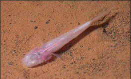
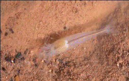
Figure 1. The Southern Cavefish at left and the Kentucky Cave Shrimp at right are good examples of fully troglobitic aquatic cave life, otherwise known as stygobites.
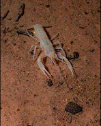
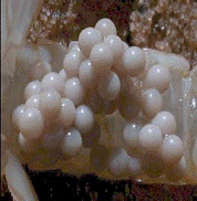
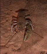
Figure 2. Note how slender the white eyeless cave adapted (troglobitic) crayfish at left is compared with the robust surface (troglophilic) crayfish at right. This cave crayfish has eggs, which are shown in the middle photo.
Common organisms living within the sediments of Mammoth Cave streams (Whitman 1989) are nematodes (undescribed), copepods (Maraenobiotus, Moraria, Nitocra, and Parastenocaris), tardigrades (Macrobiotus), and oligochaete worms (Aeolosoma). Worm castings and tracks are also visible on mud banks of cave streams, and these organisms are preyed upon by the troglobitic beetles Pseudanophthalmus striatus, P. menetriesi, and Neaphaenops tellkampfi (Kane and Ryan, 1983). This zone is an ecotone between aquatic and terrestrial cave ecosystems. As part of the community dependent upon flood-deposited organic films, the springtails Folsomia candida and Pseudosinella are preyed upon by the troglobitic harvestman Phalangodes armata. Another major ecotone exists at cave entrances where litter from surface vegetation accumulates via gravity and woodrats. Here are found the collembolans Tomocerus, Hypogastrura, Sinella, and Arrhopalites. Predators include the beetle Pseudanophthalmus, and a rhagidid mite (Poulson, 1992).
The cave cricket Hadenoecus subterraneus buries its eggs in sandy passages with moderate moisture in the constant temperature zone (Hubbell and Norton, 1978), and the blind beetle Neaphaenops is especially skilled at finding those eggs. After cave crickets, this beetle has the highest density of any species in Mammoth Cave, and a small community subsists on beetle feces (Poulson 1992, 1993). The springtail Arrhopalites and the dipluran Litocampa are consumers, which are preyed upon by the mite Arctoseius, the spider Anthrobia, and the pseudoscorpion Kleptochthonius. These latter two are in turn preyed upon by Neaphaenops cave beetles.
In addition to eggs, Hadenoecus guano is also important. Crickets feed in surface habitats at night, and return to the cave to roost. Here their guano supports the millipedes Scoterpes and Antriadesmus, the springtails Hypogastrura, Arhopalites, Pseudosinella, Tomocerus, and Lepidocyrtus, plus the bristletail Litocampa, the beetles Ptomophagus hirtus and Batrisodes henroti, the snail Carychium stygius, and the mites Ceratozetes and Belba.
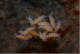
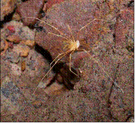
Figure 3. Tiny springtails such as these shown at left are prey for several predators including the troglobitic harvestman or daddy longlegs shown at right.
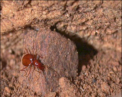
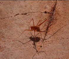
Figure 4. The blind cave beetle at left is especially adept at finding the buried eggs of the cave cricket seen in the right photo.
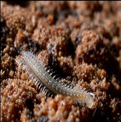
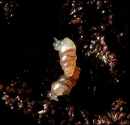
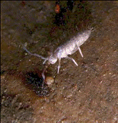
Figure 5. The troglobitic millipede, snails, and troglophilic springtail, (left to right) are all consumers of cricket guano.
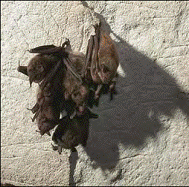
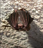
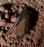
Figure 6. Gray bats (left) were once abundant and are now listed as endangered, Rafinesque's Big Eared bat (center) populations were never large, but are today a matter of concern. The Eastern Pipistrelle bat shown at right is an example of a very adaptable and tolerant species.
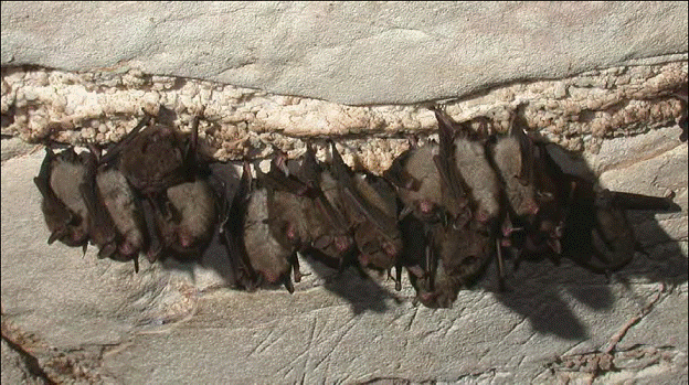
Figure 7. Populations of Indiana bats once numbered in the millions within park caves, but today are counted in the low thousands and are considered critically endangered. These individuals were photographed in Long Cave in 2003.
These in turn are preyed upon by the pseudoscorpion Kleptochthonius, the beetle Pseudanophthalmus menetriesi, the larval dipteran Macrocera nobilis, and the spider Phanetta. As well, the spider Meta americana, and the cave salamander Eurycea lucifuga are present to prey upon crickets.
Woodrats and raccoons were formerly abundant in Mammoth Cave, and though today reduced, their feces support specialized communities. Latrines of the Eastern Woodrat Neotoma floridana sustain larva of the fly Psychoda and fungus gnat Bradysia, and the beetle Ptomaphagus hirtus, which are preyed upon by the rove beetle Quedius (Richards, 1989, 1990). Raccoon feces support a similar community with the exception that cave crickets may preempt fly larvae, most notably Spelobia, and Amoebelaria.
Due to low populations, bat guano in Mammoth Cave is today negligible as an energy source (Barr and Kuehne, 1967), but would have been highly significant during pre-settlement times since Mammoth Cave was formerly one of the largest bat hibernacula in the world. Indiana Bats (Myotis sodalis) and to a lesser extent Gray Bats (M. grisescens) were prominent species in Mammoth Cave only 150 years ago, but are today listed as endangered. Little Brown Bats (M. lucifugus) were also abundant with the Big Brown Bat (Eptesicus fuscus), and Eastern Pipistrelle (Pipistrellus subflavus) being less common (Toomey et al.,1998). All together, these and more rare bat species such as M.leibii and M.septentrionalis had estimated populations of 9-12 million just in the Historic Section (Tuttle, 1997). Ecological restoration of this portion of Mammoth Cave, and facilitating the return of bats is an ongoing effort (Olson, 1996).
In addition to correcting ecological distortions to the Historic Section of Mammoth Cave, lampflora such as algae and mosses are a problem as in all show caves, and elimination via wavelength selection has been achieved on a small scale (Olson 2001). On a karst landscape scale, contamination of groundwater recharge is a major issue, especially from Interstate Highway 65 (Olson and Schaefer 2002). However, nothing is known about likely contaminants entering park waters from the CSX Railroad. Finally, a problem exists downstream on Green River in the form of Lock and Dam #6, which ponds water up into Mammoth Cave and degrades habitat for the endangered Kentucky Cave Shrimp (Olson and Leibfreid 1999).
Barr, T., 1985, Cave Life of edited by P.H. Dougherty, Kentucky Geological Survey, Series XI, Special Publication 12, Lexington, Kentucky, p. 146-167.
Barr, T., 1967, Ecological Studies in the Mammoth Cave System of Kentucky, I. The Biota. International Journal of Speleology, 3:147-203.
Culver, D., Master, L., Christman, M., and H. Hobbs, 1999, Obligate Cave Fauna of the 48 Contiguous United States14:386-401.
Hubbell, T. and R. Norton, 1978, The Systematics and Biology of the cave crickets of the North American Tribe Hadenocini (Orthoptera Saltatoria: Ensifera: Raphidophoriinae: Dolichopodinae). Miscellaneous Publication of the Museum of Zoology, University of Michigan, 156:1-80. Kane, T. and T. Ryan. 1983. Population Ecology of Carabid Cave Beetles. Oecologia, 60:46-55.
Olson, R., 1996, This Old Cave: The Ecological Restoration of the Historic Entrance Ecotone of Mammoth Cave, and Mitigation of Visitor Impact. Proceedings of the Fifth Annual Mammoth Cave National Park Science Conference. Mammoth Cave National Park, KY: National Park Service, p. 87-95.
Olson, R., 2001, Control of Lamp Flora in Mammoth Cave National Park. International Conference on Cave Lighting Proceedings, edited by Tamas Hazslinszky, Hungarian Speleological Society, Budapest, Hungary, p. 131.
Olson, R., and T. Leibfreid, 1999, The Importance of Inventory and Monitoring Data sets in Resolving Ecosystem Management Problems at Mammoth Cave National Park. In: On the Frontiers of Conservation, Proceedings of the 10th Conference on Research and Resources Management in Parks and on Public Lands, edited by Dave Harmon, p.149-155.
Olson , R. and J. Schafer, 2002, Planned Spill Retention and Runoff Filtration Structures on Interstate 65 in the South-Central Kentucky Karst. 15th National Cave and Karst Management Symposium Proceedings, USDA Forest Service, Tucson, AZ, p. 203.
Poulson, T., 1992, The Mammoth Cave Ecosystem. In The Natural History of Biospeleology, edited by A.I. Camancho, Monographs of the National Museum of Natural Sciences, Madrid, Spain, p. 564-611.
Poulson, T., 1993, Cave Animals of Mammoth Cave National Park. Unpublished guide on file at Mammoth Cave National Park. 35 p.
Richards, P., 1989, Predation in the Cave Rat Fecal Latrine. Cave Research Foundation Annual Report, p. 45-47.
Richards, P., 1990, The Effects of Predation on Invertebrate Community Structure in the Cave Rat Fecal latrine. Cave Research Foundation Annual Report, p. 58-61.
Toomey, R., Colburn, M., Schubert, B., and R. Olson, 1998, Vertebrate Paleontological Projects at Mammoth Cave National Park. Proceedings of Mammoth Cave National Park's Seventh Science Conference. Mammoth Cave National Park, KY: National Park Service, p. 9-14.
Tuttle, M, 1997, A Mammoth Discovery. Bats. Bat Conservation International, 15:4, p. 3.
Whitman, R., 1989, Sand Dwelling Animals of Mammoth Cave. Unpublished report on meiofauna in Mammoth Cave on file at Mammoth Cave National Park. 75 p.

![]() U.S. Department of the Interior |
U.S. Geological Survey
U.S. Department of the Interior |
U.S. Geological Survey
URL: http://pubsdata.usgs.gov/pubs/sir/2008/5023/44toomey.htm
Page Contact Information: Eve L. Kuniansky
Page Last Modified: Thursday, 10-Jan-2013 15:24:00 EST