Alaska Science Center
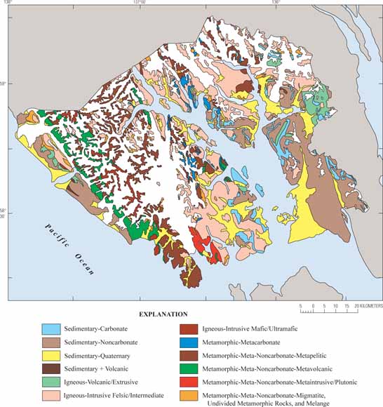
Map showing bedrock-lithologic units in Glacier Bay National Park, southeast Alaska (from figure 3).
Landform and generalized bedrock lithologic units have been delineated for ecological landtype association analysis in Glacier Bay National Park in southeast Alaska (as the Park boundaries were defined before the 1971 Alaska National Interest Lands expansion).
Related U.S. Forest Service efforts have covered (1) the whole region at coarse ecological- unit scale, including domains, divisions, provinces, sections, and subsections; and (2) small parts the region at subsection scale. These small parts are generally forest-covered shoreline to timberline areas with relatively subdued topography, extensive bedrock exposures, and no active glaciers. The detailed studies established that the combination of landform and bedrock-lithologic information was a good indicator of ecosystem productivity and types of plant communities.
This study of Glacier Bay National Park covers areas similar to those of the detailed studies but also includes a large proportion of high (15,300 feet), glacier-clad alpine terrain and large, active-valley glacier systems. This terrain reflects (1) the orographic and microclimatic effects associated with the high-altitude barrier that is the Fairweather Range part of the St. Elias Mountains and its rapidly retreating glaciers, and (2) the geologic, tectonic, and erosional history of this range.
In this study, landforms were classified—by using topographic maps and personal experience—into eight categories similar to those used by the U.S. Forest Service. The 90 bedrock-lithologic units on the current Glacier Bay geologic map were classified into 13 generalized lithologic units corresponding exactly to those used by the U.S. Forest Service. Incomplete storm-track, storm-intensity, and limited climatic information have also been compiled.
Download this report as a 14-page PDF file (sir2008-5183.pdf; 875 kB).
For questions about the content of this report, contact Dave Brew
Suggested citation and version history
Download a free copy of the current version of Adobe Reader.
| Help
| PDF help
| Publications | Western Scientific Investigations Reports |
| Geology Disipline | Alaska Science Center | Alaska Mineral Resources |
This report is availalbe only on the Web

![]() U.S. Department of the Interior | U.S. Geological Survey
U.S. Department of the Interior | U.S. Geological Survey
URL: http://pubs.usgs.gov/of/2008/5183/
Page Contact Information: Michael Diggles
Page Created: October 31, 2008
Page Last Modified: November 10, 2008
(mfd)