Scientific Investigations Report 2010–5065
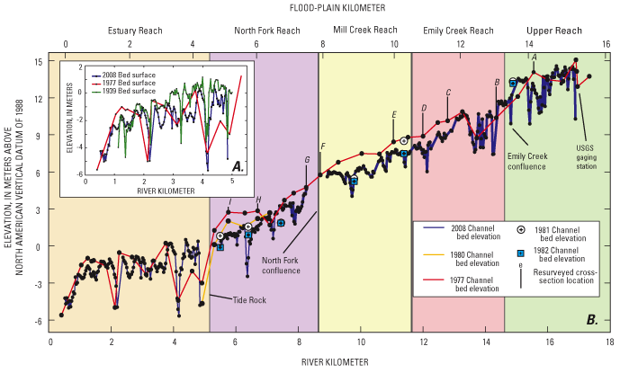
Figure 18. Channel thalweg profiles downstream of river kilometer 18, Chetco River, Oregon. (A) Channel thalweg profiles for Estuary Reach extracted from (1) bathymetric survey of 1939 (U.S. Army Corps of Engineers, 1939), (2) cross sections from 1977 flood study survey (Soil Conservation Service, 1979), and (3) bathymetric survey in 2008 by U.S. Geological Survey. (B) Channel thalweg profiles from bathymetric flood study survey in 1977 (Soil Conservation Service, 1979), and channel survey in 2008 by U.S. Geological Survey. Thalweg elevations for surveys in 1980–82 are from Oregon Department of State Lands surveys, as reported by Klingeman (1993). Upper case letters show locations of resurveyed cross sections. |
First posted May 26, 2010 For additional information contact: Part or all of this report is presented in Portable Document Format (PDF); the latest version of Adobe Reader or similar software is required to view it. Download the latest version of Adobe Reader, free of charge. |

![]() U.S. Department of the Interior | U.S. Geological Survey
U.S. Department of the Interior | U.S. Geological Survey
URL: http://
pubsdata.usgs.gov
/pubs/sir/2010/5065/figure18.html
Page Contact Information: Contact USGS
Page Last Modified:
Thursday, 10-Jan-2013 19:10:01 EST
