Scientific Investigations Report 2010–5065
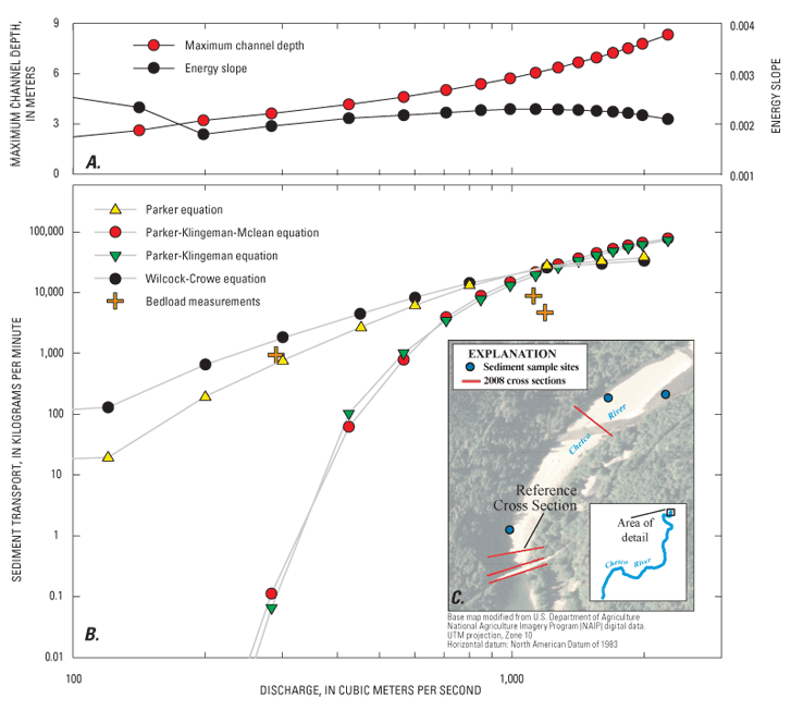
Figure 30. Streamflow hydraulics, calculated and measured bed-material transport, and location map for vicinity of measurement site near flood-plain kilometer 15.3 on Chetco River, Oregon. (A) Modeled flow depth and energy slope for reference cross section at flood-plain kilometer 15.3. (B) Calculated bed-material transport rates at reference cross section at flood-plain kilometer 15.3 for four bed-material transport equations described in text. Also shown are measured bedload transport rates for three measurements made from bridge at flood-plain kilometer 15.24. (C) Location of streamflow-model cross sections, bed-material transport calculations (reference cross section), the bridge from which the bedload measurements were made (which is also the location of the USGS streamflow-gaging station), and location of sediment samples from which grain-size measurements were averaged for calculating bedload transport rates. |
First posted May 26, 2010 For additional information contact: Part or all of this report is presented in Portable Document Format (PDF); the latest version of Adobe Reader or similar software is required to view it. Download the latest version of Adobe Reader, free of charge. |

![]() U.S. Department of the Interior | U.S. Geological Survey
U.S. Department of the Interior | U.S. Geological Survey
URL: http://
pubsdata.usgs.gov
/pubs/sir/2010/5065/figure30.html
Page Contact Information: Contact USGS
Page Last Modified:
Thursday, 10-Jan-2013 19:10:12 EST
