Scientific Investigations Report 2010–5259
ABSTRACT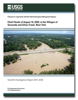
Late during the night of August 9, 2009, two storm systems intersected over western New York and produced torrential rain that caused severe flash flooding during the early morning hours of August 10 in parts of Cattaraugus, Chautauqua, and Erie Counties. Nearly 6 inches of rain fell in 1.5 hours as recorded by a National Weather Service weather observer in Perrysburg, which lies between Gowanda and Silver Creek—the communities that suffered the most damage. This storm intensity had an annual exceedance probability of less than 0.2 percent (recurrence interval greater than 500 years). Although flooding along Cattaraugus Creek occurred elsewhere, Cattaraugus Creek was responsible for very little flooding in Gowanda. Rather the small tributaries, Thatcher Brook and Grannis Brook, caused the flooding in Gowanda, as did Silver Creek and Walnut Creek in the Village of Silver Creek. Damages from the flooding were widespread. Numerous road culverts were washed out, and more than one-quarter of the roads in Cattaraugus County were damaged. Many people were evacuated or rescued in Gowanda and Silver Creek, and two deaths occurred during the flood in Gowanda. The water supplies of both communities were compromised by damages to village reservoirs and water-transmission infrastructures. Water and mud damage to residential and commercial properties was extensive. The tri-county area was declared a Federal disaster area and more than $45 million in Federal disaster assistance was distributed to more than 1,500 individuals and an estimated 1,100 public projects. The combined total estimate of damages from the flash floods was greater than $90 million. Over 240 high-water marks were surveyed by the U.S. Geological Survey; a subset of these marks was used to create flood-water-surface profiles for four streams and to delineate the areal extent of flooding in Gowanda and Silver Creek. Flood elevations exceeded previously defined 0.2-percent annual exceedance probability (500-year recurrence interval) elevations by 2 to 4 feet in Gowanda and as much as 6 to 8 feet in Silver Creek. Most of the high-water marks were used in indirect hydraulic computations to estimate peak flows for four streams. The peak flows in Grannis Brook and Thatcher Brook were computed, using the slope-area method, to be 1,400 and 7,600 cubic feet per second, respectively, and peak flow in Silver Creek was computed, using the width-contraction method, to be 19,500 cubic feet per second. The annual exceedance probabilities for flows in these and other basins with small drainage areas that fell almost entirely within the area of heaviest precipitation were less than 0.2 percent (or recurrence intervals greater than 500 years). The peak flow in Cattaraugus Creek at Gowanda was computed, using the slope-area method, to be 33,200 cubic feet per second with an annual exceedance probability of 2.2 percent (recurrence interval of 45 years). |
First posted February 3, 2011 For additional information contact: Part or all of this report is presented in Portable Document Format (PDF); the latest version of Adobe Reader or similar software is required to view it. Download the latest version of Adobe Reader, free of charge. |
Szabo, C.O., Coon, W.F., and Niziol, T.A., 2010, Flash floods of August 10, 2009, in the Villages of Gowanda and Silver Creek, New York: U.S. Geological Survey Scientific Investigations Report 2010-5259, 23 p., available at http://pubs.usgs.gov/sir/2010/5259.
Abstract
Introduction
Antecedent Hydrologic Conditions
Storm Characteristics
Description of the Floods
Collection of High-Water-Mark Data
Floodwater-Surface Profiles
Areal Extent of Flooding
Magnitudes of Peak Streamflows
Annual Exceedance Probabilities of Peak Streamflows
Summary
Acknowledgments
References Cited
Appendix 1. High-water marks in the Villages of Gowanda and Silver Creek, N.Y.,
for the flash floods of August 10, 2009

![]() U.S. Department of the Interior |
U.S. Geological Survey
U.S. Department of the Interior |
U.S. Geological Survey
URL: http://
pubsdata.usgs.gov
/pubs/sir/2010/5259/index.html
Page Contact Information: USGS Publications Team
Page Last Modified: Thursday, 10-Jan-2013 19:21:39 EST
