Scientific Investigations Report 2013–5135
Model ScenariosTo assess changes in water quality, scenario-specific results were compared to results from the base case (current conditions) model documented in Sullivan and others (2013) for calendar years 2006–09. After each scenario was constructed and run, the model water-surface elevation at Keno Dam was assessed to ensure that it was unchanged from the base case model. This allowed base case and model scenario results to be directly compared without confounding traveltime or storage effects from water stage differences. Some of the scenarios that examine treatment options are exploratory in nature and include end member cases, to examine the range of possible effects. Methodology and results from all scenarios (table 2) are discussed in this report in numerical order. Scenarios 1 and 2. Water-Quality Conditions Before and After TMDL ImplementationThe Klamath River TMDL specifies total nitrogen, total phosphorus, and BOD5 allocations for point and nonpoint tributary sources along the Link-Keno reach. The Upper Klamath Lake TMDL specifies an in-lake total phosphorus target; the water quality of Upper Klamath Lake affects the Klamath River’s upstream inflow at Link River. Scenarios 1 and 2 were formulated to assess the water-quality changes in the upper Klamath River if the upper Klamath River TMDL tributary source allocations and Upper Klamath Lake TMDL target were met, both separately (scenarios 1b, 2a) and together (scenario 2b) (table 2). MethodsMethods to construct scenarios 1 and 2 were described in Sullivan and others (2011). The model runs in this study were similar, but used updated and recalibrated USGS models, which included macrophytes and enhanced pH-buffering calculations (Sullivan and others, 2013) that were not included in the previous USGS model runs (Sullivan and others, 2011). Because the new pH buffering algorithms apportion some alkalinity to organic matter, ammonia, and orthophosphorus, recalculation of the total inorganic carbon (TIC) concentrations in the boundary input files was necessary (see Sullivan and others, 2013). This TIC recalculation applied to all boundary inputs, including Link River, point sources (Klamath Falls and South Suburban wastewater treatment plants) and nonpoint sources (Lost River Diversion Channel, Klamath Straits Drain). In addition to recalculating TIC for base case conditions, inflow TIC for the upstream and point and nonpoint sources was recalculated for scenarios in which inflow concentrations of organic matter, ammonia, and (or) orthophosphorus were decreased to be consistent with TMDL allocations. If concentrations of nutrients, organic matter, and (or) algae were decreased in the inflows by changes that affected the watershed ecosystem of those sources, the pH of those waters could have changed as well; pH affects the calculation of TIC. Predicting pH changes that might occur outside the model boundary is more difficult, so some sensitivity analyses explored the ramifications of boundary pH changes during 2007. For this bracketing, TIC was calculated twice: first using measured pH and second using an estimated pH that might have occurred in the presence of a smaller algal population (low-bloom condition). Considering winter background pH of inflows (pH approximately 7.0–8.0) with some minor primary production in summer, might lead to maximum pH values of approximately 8.5. Thus, the low-bloom pH was estimated by setting any inflow pH values greater than 8.5 to 8.5. Under the base case, current conditions, the measured pH for some inputs were greater than 9.5 for some periods during the year. Separate model runs were conducted for each of these conditions. ResultsScenario 1 and 2 results from the updated model were similar to scenario results from the original model as discussed in Sullivan and others (2011). Inflow nutrient decreases in Link River (to meet the Upper Klamath Lake TMDL target) and in the two wastewater treatment plants, Lost River Diversion Channel and Klamath Straits Drain (to meet Klamath River TMDL allocations) together (scenario 2b) were effective at improving water quality in the Link-Keno reach of the upper Klamath River, as measured by increased dissolved‑oxygen concentrations, decreased ammonia concentrations, and improvements in other water-quality parameters (fig. 4; tables A1, A2). The predicted improvement in water quality caused by the attainment of the Upper Klamath Lake TMDL target, as reflected by improved Link River inflow quality, was more than the improvement in water quality associated with the TMDL attainment of all other inflows combined. For instance, the Link-Keno volume-average dissolved-oxygen concentration for June through October was predicted to increase 2.4–3.6 mg/L (54–126 percent) depending on model year, when Link River water quality reflected attainment of the Upper Klamath Lake TMDL target (scenario 2a) compared to base case (scenario 1a) conditions (fig. 4; table A2). In contrast, the dissolved-oxygen concentration was predicted to increase by much less, 0.1–0.2 mg/L (2–4 percent), through the attainment of all Klamath River TMDL allocations at the two wastewater treatment plants, the Lost River Diversion Channel, and the Klamath Straits Drain (scenario 1b), compared to base case conditions. Similarly, water quality improvements for ammonia, chlorophyll a, particulate organic carbon, dissolved organic carbon, total phosphorus, and total nitrogen were notably greater when Link River inputs reflected attainment of the Upper Klamath Lake TMDL target compared to when the other inflows met Klamath River TMDL allocations (tables A1, A2). Decreases in orthophosphorus concentration, on the other hand, were notable both when Link River reflected Upper Klamath Lake TMDL attainment (scenario 2a) and when the in-reach inflows met Klamath River TMDL allocations (scenario 1b): June–October orthophosphorus concentrations decreased 0.04–0.07 mg/L with the first condition and 0.02–0.03 mg/L under the second compared to base case conditions (scenario 1a) (table A2). Upper Klamath Lake inflows are a dominant factor in determining water quality in the Link-Keno reach of the Klamath River, particularly during summer. Other sources of water to the reach can be important in affecting certain constituents such as phosphorus, but significant changes to water quality in this reach are unlikely without alterations in the quality of Upper Klamath Lake inflows. Scenario 3. Compliance with Dissolved Oxygen, pH, and Ammonia Toxicity CriteriaScenario 3 extended scenarios 1 and 2 by comparing those results to the relevant Oregon dissolved oxygen, pH, and ammonia toxicity criteria. Chlorophyll a results from the model were not compared to the State of Oregon action level in this study because the TMDL was not written to demonstrate compliance with the chlorophyll a criterion; rather, it was assumed that achieving compliance with the dissolved-oxygen and pH criteria would be more directly protective of aquatic life (Oregon Department of Environmental Quality, 2010). Water temperature was not included in this analysis because water temperature allocations to point and nonpoint sources were determined based on basin-specific rule language instead of instream analysis (oral commun., Daniel Turner, Oregon Department of Environmental Quality). Water Quality CriteriaThe relevant numeric dissolved oxygen, pH, and ammonia toxicity criteria for the Link-Keno reach were based on State of Oregon standards specific to the Link-Keno reach of the Klamath River (Oregon Department of Environmental Quality, 2011). During the modeling and analysis process to determine TMDL allocations, ODEQ examined water quality criteria compliance at seven locations in the Link-Keno reach: at the inflow locations of the Klamath Falls wastewater treatment plant (USGS model segment 4), South Suburban wastewater treatment plant (segment 8), Lost River Diversion Channel (segment 19), and Klamath Straits Drain (segment 69), as well as at monitoring sites Miller Island (segment 38), KRS12a (segment 78), and Keno (segment 95) (figs. 1 and 3). Prior analysis demonstrated that these selected locations were representative of dissolved oxygen conditions in the reach (Sullivan and others, 2012). Dissolved OxygenThe dissolved-oxygen standard for the Link-Keno reach of the Klamath River defines the numeric criteria as “…the dissolved oxygen may not fall below 6.5 mg/L as a 30-day mean minimum, 5.0 mg/L as a 7-day minimum mean, and may not fall below 4.0 mg/L as an absolute minimum…” when sufficient data are available to compute these statistics, as is the case with continuous monitor data or model results (Oregon Department of Environmental Quality, 2011). All three of these numeric criteria must be attained to achieve compliance. The “30-day mean minimum” is defined as the minimum of the 30 consecutive-day floating average of the calculated daily mean, and the daily mean is computed such that “concentrations in excess of 100 percent of saturation are valued at the saturation concentration.” The “7-day minimum mean” is defined as the minimum of the 7 consecutive-day floating average of the daily minimum concentration. The “4.0 mg/L as an absolute minimum” is an instantaneous criterion and was checked with hourly results. The State of Oregon standards do not specify whether the numeric criteria were based on depth-averaged or volume-averaged concentrations. ODEQ used depth-averaged dissolved-oxygen concentrations to compare to these dissolved-oxygen criteria. A previous modeling study (Sullivan and others, 2012) determined that dissolved oxygen depth-average concentrations in the upper Klamath River typically were lower than volume-average concentrations. Depth averaging gave relatively higher weight to small-volume areas near the channel bottom that often had lower dissolved-oxygen concentration. The current modeling study used volume-average dissolved-oxygen concentrations because that result was more representative of average dissolved-oxygen concentration when the entire cross section was considered. Additional rule language for sources in this reach states that “no measurable reduction of dissolved oxygen” shall result, where “measurable reduction” is defined as “…no more than 0.20 mg/L for all anthropogenic activity.” This 0.20 mg/L rule was one of the primary measures used during the determination of allocations for point and nonpoint sources for the Klamath River TMDL (oral commun., Daniel Turner, Oregon Department of Environmental Quality). pHThe relevant Oregon pH standard for this reach of the Klamath River defines the numeric criteria as “…pH values may not fall outside the range of 6.5-9” (Oregon Department of Environmental Quality, 2011). ODEQ compared model results to the criteria at a depth of 1.1 m from the surface on an hourly basis at the seven compliance locations. The same approach was used in this study. Ammonia ToxicityAmmonia occurs in natural waters as either ammonium (NH4+) or un-ionized ammonia (NH3). Un-ionized ammonia is the predominant form when the pH is greater than about 9.3, and is the form that is toxic to fish. The un-ionized form of ammonia increases as pH and temperatures increase. The State of Oregon ammonia toxicity criteria, based on that of the U.S. Environmental Protection Agency (EPA), are set according to concentrations of the un-ionized ammonia form and are a function of water temperature (T) and pH (U.S. Environmental Protection Agency, 1986). The numeric criteria equations take different forms depending on whether salmonids and other coldwater species are present; the upper Klamath River TMDL used equations that assumed that coldwater species were present (Oregon Department of Environmental Quality, 2010). The acute ammonia toxicity criteria were designed to protect fish against acute toxic effects such as loss of equilibrium, hyperexcitability, increased breathing, cardiac output, convulsions, coma, or death (U.S. Environmental Protection Agency, 1986). The chronic ammonia toxicity criteria were designed to protect fish from lower level concentration effects such as reduction in hatching success or growth, and pathological changes in gill, liver, and kidney tissues (U.S. Environmental Protection Agency, 1986). The acute criteria, in milligrams per liter as NH3, are calculated as 0.52/FT/FPH/2, and the chronic criteria are calculated as 0.80/FT/FPH/Ratio. The equation parameters are defined as:
The acute criteria were applied using 1-hour average concentration of un-ionized ammonia. The chronic criteria were applied based on the 4-day average un-ionized ammonia concentrations. The EPA states that the equations should not be applied outside the pH range of 6.5 to 9.0 or a water temperature range of 0 to 30°C (U.S. Environmental Protection Agency, 1986). Because alternate equations were not provided for conditions outside this pH range, and because ODEQ applied these equations to all upper Klamath River conditions without modification, this study mirrored that approach. ODEQ applied the criteria during model analysis at a depth of 1.1 m from the surface at the seven compliance locations. The same method was followed for this study. The EPA criteria in the equations above are for un-ionized ammonia in units of milligrams per liter as NH3. In this report, the criteria for un-ionized ammonia in milligrams per liter as NH3 were converted to an equivalent concentration of total ammonia (ammonium plus ammonia) in milligrams per liter as nitrogen (N) using well-known equations for the speciation of ammonia as a function of pH and temperature. Natural Conditions Effect on CriteriaIn Oregon, all previously described numeric water-quality criteria can be superseded if it is determined that water quality under “natural conditions” would be of lower quality for a specific time and place. Oregon Administrative Rules state, “Where a less stringent natural condition… exceeds the numeric criteria… the natural condition supersedes the numeric criteria” (Oregon Department of Environmental Quality, 2011). For instance, if the numeric instantaneous dissolved-oxygen criterion is 4.0 mg/L, but analysis indicated that the dissolved-oxygen concentration under natural conditions for a certain place and time would be 3.8 mg/L, then 3.8 mg/L becomes the applicable criteria. Natural conditions is defined as “conditions or circumstances affecting the physical, chemical, or biological integrity of a water of the state that are not influenced by past or present anthropogenic activities” (Oregon Department of Environmental Quality, 2011). Anthropogenic activity that modified flow began prior to 1900 in the Klamath Basin, when little to no quantitative flow or water-quality data were available. In the dissolved-oxygen criteria analyses for this report, model simulations to approximate natural conditions of water quality were constructed by assuming a level of improved water quality from Upper Klamath Lake and limited effects from nonpoint and point sources. These simulations are termed “reference condition” to acknowledge that they represent only an approximation of natural conditions. More specifics of the reference conditions model construction, and how the USGS-Watercourse-Reclamation reference conditions analysis differs from that used in the TMDL, are described in Sullivan and others (2012). ResultsComparison to Dissolved-Oxygen CriteriaMeasured and simulated dissolved-oxygen concentrations were well above the relevant criteria in winter, spring, and late fall. In the base case (scenario 3(1a)) conditions of 2006–09, dissolved-oxygen concentrations were less than the criteria in the Link-Keno reach of the Klamath River in summer through early fall (fig. 5). At that time of year, the river had large loads of decomposable organic matter, which consumed oxygen during decay. Water temperatures were warmer during this period, which decreased the solubility of oxygen in water. The maximum number of days that any of the three numeric criteria were not met in any scenario year ranged as high as 143 days and tended to be at least about 100 days at most locations in the base case (table 3); in the years modeled, the 30-day criteria were more difficult to attain compared to the 7-day or instantaneous criteria, so the results in table 3 are for the 30-day criteria analysis. The average concentration below the criteria for that period ranged from 1.2 to 3.7 mg/L for key locations in the base case (table 3). Under base case conditions, some part of the Link-Keno reach was less than dissolved oxygen criteria for at least 3 months in summer in all years modeled. Dissolved oxygen conditions generally worsened from upstream to downstream for several reasons: inflowing oxygen concentrations were elevated from aeration at Link Dam and Link River, oxygen demand increased downstream as algae and particulate organic matter settled and decayed, and inflows of oxygen-demanding material or low dissolved-oxygen levels entered the river from point sources (for example, Klamath Falls and South Suburban wastewater treatment plants) and nonpoint sources (Lost River Diversion Channel and Klamath Straits Drain) along the reach. Setting Link River nutrient and organic matter concentrations at lower values (scenario 3(2a)) to reflect the Upper Klamath Lake TMDL target led to increased attainment of dissolved-oxygen criteria in the upper Klamath River. In that scenario, the upper areas of the reach, close to Link River, improved from levels less than the dissolved-oxygen criteria for 3 months of the year (scenario 3(1a)) to attaining the criteria at all locations and times (scenario 3(2a); table 3). The more downstream reach of this study area, closer to Keno Dam, was still less than the dissolved-oxygen criteria in this scenario, although the period was shorter, and when digressions occurred, concentrations were much closer to the criteria. For example, in the 2009 base case 3(1a), at segment 69 at the Klamath Straits Drain inflow, for the 142 days when dissolved-oxygen criteria were not attained, waters were less than the criteria by an average of 3.4 mg/L. In scenario 3(2a), that location did not attain dissolved-oxygen criteria on 86 days, but the concentrations were less than the criteria by an average of 0.1 mg/L for the 86 days. Simulating point and nonpoint sources along the Link-Keno reach in compliance with Klamath River TMDL allocations (scenario 3(1b)) shifted the river toward compliance with dissolved-oxygen criteria, but in fewer locations and to a lesser amount than simulating Link River inflows in compliance with the Upper Klamath Lake TMDL. Simulating in-reach point and nonpoint sources to meet TMDL allocations was most effective at bringing the river into compliance with water quality criteria when Link River was already at the Upper Klamath Lake TMDL target. For Keno (segment 95) in 2008, the base case results were less than the criteria for 142 days by an average of 3.2 mg/L; when Link River TMDL compliance was assumed, water quality improved and the dissolved-oxygen concentrations were less than the criteria on 82 days by an average of 0.3 mg/L (table 3). Adding in Klamath River point and nonpoint source TMDL compliance provided sufficient additional improvement to achieve dissolved oxygen compliance at Keno for the entire year. Comparison to pH CriteriaThe pH in the Link-Keno reach was greater than the 9.0 maximum criterion during some periods in summer under base case conditions when algal blooms occurred (figs. 6A, 6B). The minimum pH criterion of 6.5 was attained in all model runs for scenarios 1 to 3. Unlike dissolved oxygen, where digressions from the criteria were more common in the mid and downstream reaches, pH 9.0 criteria exceedances were most frequent in the upstream reaches (table 4). A primary cause of elevated pH was related to algal blooms in Upper Klamath Lake, which enter the upper Klamath River through the Link River. Algal populations decreased from upstream to downstream in the Link-Keno reach (Sullivan and others 2008, 2009), so pH values also decreased in the downstream direction. The pH effects associated with compliance of Upper Klamath Lake/Link River and in-reach tributary sources with TMDL targets and allocations were more difficult to predict. The pH was not only related to in-reach reactions that are capably modeled by the CE-QUAL-W2 model, but also the TIC and alkalinity of the inflows, which likely would change if the upstream watersheds were managed or altered to meet upstream TMDL allocations. Thus, the effect on TIC and alkalinity could be different depending on upstream management actions. For year 2007, scenarios 3(1b), 3(2a), and 3(2b) were run twice, first by assuming that inflow pH and TIC would be unchanged after the Klamath River TMDL allocations or Upper Klamath Lake target were met, and again by estimating the pH and TIC conditions that might occur in the presence of smaller algal blooms in those inflows. The difference in model output was minor in 3(1b), but significant in 3(2a) and 3(2b), the runs that simulated Link River with Upper Klamath Lake at its TMDL target. As an example, at Miller Island (segment 38) in 2007 for scenario 3(2a), the model predicted that the pH would exceed the criteria for 78 days if inflow pH and TIC were unchanged or above the criteria for only 23 days if inflow pH and TIC were estimated to account for smaller algal blooms upstream (table 4, figs. 6A, 6B). With the model predicting elevated pH conditions to occur when TMDLs were met, such as in scenario 3(2b) compared to the base case, the cause of the elevated conditions provides a good illustration of the difficulties in accurately predicting a future pH condition. Under base‑case conditions, pH tends to increase or decrease largely depending on the levels of photosynthesis and respiration that occur. Photosynthesis removes dissolved carbon dioxide (essentially carbonic acid) from the water, and respiration processes release carbon dioxide (carbonic acid) back into the water. Removing acid increases the pH, and adding acid decreases the pH. During a bloom, the pH tends to be high because of the removal of carbon dioxide for the production of biomass, whereas after a bloom declines, the pH decreases to a level that tends to be less than the maximum pH criterion. During a large algal bloom in Upper Klamath Lake, the pH is high and TIC concentration is low in Link River. In the Link-Keno reach, substantial amounts of TIC are released from decomposing algae and organic material, allowing the pH to decrease downstream. If a model scenario removed large populations of algae from the Link River inflow but did not adjust the pH or TIC, then the pH in the Link-Keno reach tended to stay elevated because the amount of carbon entering the reach was too small to replenish the TIC through subsequent decomposition and respiration processes. In estimating the effects of management activities that might decrease upstream inputs of algal populations, downstream pH conditions depend greatly on the pH and TIC of the inflows, which is the reason the analysis in this report bracketed a range of potential conditions for one of the modeled years. A natural conditions analysis was not undertaken for the pH criteria in this study. If natural conditions were taken into account, for some periods when the pH was simulated to exceed the pH 9.0 criterion, natural conditions pH also may also have been elevated, causing the relevant pH criteria to be greater than 9.0. Therefore, the number of days the criterion was exceeded may be overstated in this analysis; however, this was considered a conservative assumption. Comparison to Ammonia Toxicity CriteriaNumeric ammonia toxicity criteria vary in space and time because the criteria are based on pH and temperature. In winter when pH values were near-neutral and temperatures were low, the criteria were relatively high. Although ammonia concentrations were elevated during winter, the acute and chronic ammonia toxicity criteria were even greater at that time of year (figs. 6A, 6B). During summer, however, when pH was elevated and temperatures were warm, the calculated ammonia toxicity criteria decreased, so it was more likely that the ammonia criteria would be exceeded. Upper Klamath River waters were simulated to exceed the acute ammonia toxicity criteria between 0 and 27 days for the base case conditions for the years and selected locations shown in table 5. Exceedances of the chronic ammonia toxicity criteria were simulated to be more frequent, between 27 and 118 days for the base case (table 6), and most common in the upstream part of the reach nearer Link River. Similar to the pH criteria analysis, the simulation of exceedances of the chronic ammonia toxicity criteria was sensitive to inflow TIC values. For example, at Miller Island (segment 38) for scenario 3(2a) in 2007, the number of days exceeding the criteria varied from 83 to 29 depending on whether the TIC was calculated from base case pH conditions or a potentially lower pH under conditions with less algae (table 6, fig. 6A, 6B). The simulated range of exceedance days, however, illustrates the importance of determining the effect of upstream management activities on pH conditions; for these simulations, insufficient information was available for these scenarios to provide estimates that are more certain. A natural conditions analysis was not undertaken in this study to assess the potential ammonia toxicity conditions in that reference condition. Scenario 4. Compare USGS Model and TMDL Model ResultsAs part of the TMDL process, ODEQ and Tetra Tech, Inc. developed a water-quality model for almost the entire Klamath River, including the Link-Keno reach, based on a CE-QUAL-W2 model previously developed for a dam‑relicensing process by Watercourse (Watercourse Engineering, Inc., 2004). That model from Watercourse was used to construct a modified model for the Link-Keno reach for the years 2000 and 2002 (Tetra Tech, Inc., 2009). The data used to drive the model, however, did not include direct measurements of organic matter concentrations, organic matter partitioning, or algae species. The technical basis of the TMDL model for the Link-Keno reach was reviewed and evaluated previously by the USGS (Rounds and Sullivan, 2009 and 2013). MethodsThe TMDL model and the more recent USGS model were developed for different years, so their specific predictions cannot be compared directly. A qualitative comparison was made by Sullivan and others (2012) with the 2006–09 USGS input files applied to the TMDL model. That comparison provided a qualitative way to examine the effect of differences between the models in organic matter partitioning, algae algorithms, parameter values, bathymetry, and the nature of the sediment oxygen demand formulation. In the current analysis, the comparison was rerun using the updated USGS model that includes macrophytes and enhanced pH buffering (Sullivan and others, 2013). ResultsComparisons of model results for most constituents were similar to those documented by Sullivan and others (2012); therefore, only pH, the newest calibrated constituent of the USGS model, is discussed here. Use of the updated USGS model with enhanced pH buffering produced results that more closely compare to the measured pH (fig. 7). Most versions of CE-QUAL-W2, including that used for the TMDL model, only consider carbonate alkalinity in the calculation of pH, and do not consider buffering by organic matter, orthophosphorus, or ammonia. Buffering by organic matter was demonstrated to be important in the upper Klamath River ecosystem by Sullivan and others (2013). The addition of macrophytes to the USGS model also helped to improve the simulation of pH in the Link-Keno reach, because photosynthetic activity tends to increase the pH of the river. The influence of macrophytes on pH was especially important in the downstream part of the model domain near Keno, where macrophytes were most populous. Scenario 5. Particulate Matter ShuntingFor scenario 5, the effect of shunting or diverting particulate material away from withdrawal canals was examined; particulate material suspended in the water column remained in the Klamath River when water was withdrawn through canals to the Lost River basin. Although the work presented here primarily focuses on the effects in the Klamath River between Link River and Keno Dam, a potential future extension of this scenario could examine how this decrease in particulate material into the Lost River might affect water quality in that basin. MethodsIn the current study, the scenario 5 setup was unchanged from Sullivan and others (2012), except that this scenario was run with the updated model that includes macrophytes and enhanced pH buffering (Sullivan and others, 2013). In brief, although water withdrawals from the Klamath River continued for all or part of each year to the A Canal, Lost River Diversion Channel, North Canal, and Ady Canal, particulate material was assumed “filtered” so that it stayed in the Klamath River instead of leaving the river through these canals. The shunted particulate matter included inorganic suspended sediment, labile particulate organic matter, refractory particulate organic matter, and all algae types (blue-green algae, diatoms, and other algae). The A Canal is outside the Link-Keno model boundary, so the effect of shunting particulate matter was calculated and then that load was added to the Link River inflow. Shunting for the other canals was accomplished within the model by alterations to the CE-QUAL-W2 source code (Sullivan and others, 2012), wherein particulate matter simply remained in the river and was not withdrawn. If less particulate matter were exported into the Lost River basin, it is possible that decreased loads of certain materials would return to the Klamath River through canals, which bring water from the Lost River basin to the Klamath River. Because the Lost River basin was outside the model boundary, potential variations in return flow water quality for the Lost River Diversion Channel and Klamath Straits Drain returns was examined with a bracketing approach. Scenario 5a represented an end member that assumed base case return flow concentrations. Scenario 5c represented an end member that assumed dissolved-oxygen concentrations were at saturation and that concentrations of particulate and dissolved nutrients, algae, and organic matter were zero for the Lost River Diversion Channel and Klamath Straits Drain returns. Clearly, zero concentrations of those constituents is unlikely in any future condition, but scenario 5c serves to examine the potential effect of large changes in the characteristics of the return flows. Scenario 5b instituted intermediate changes to return flow concentrations in the Lost River Diversion Channel and Klamath Straits Drain. ResultsIn general, scenario 5 results using the updated model indicated that shunting would degrade water quality in the Link-Keno reach compared to the base case. For instance, the model predicted a June–October decrease in Link-Keno reach volume-average dissolved-oxygen concentration of between 1.3 and 2.3 mg/L, compared to the base case (1a), depending on year and scenario (table A4, fig. 8), and June–October reach-averaged concentrations of dissolved oxygen in the base case (1a) were already low (2.85-4.60 mg/L) (table A4). Ammonia, chlorophyll a, particulate organic carbon, total nitrogen, and accumulated sediment concentrations all increased in these shunting scenarios, consistent with the increased input loads of particulate material. The simulations predicted that nitrate concentrations would decrease, primarily because of lower dissolved-oxygen concentrations to support ammonia nitrification. Orthophosphorus, total phosphorus, and dissolved organic carbon concentrations either increased or decreased depending on the scenario (tables A3 and A4). Variability in the characteristics of the return flow water in Lost River Diversion Channel and Klamath Straits Drain, as expressed in the differences in simulation results from scenarios 5a, 5b, and 5c, had only a minor effect on Link-Keno water quality (tables A3 and A4). As discussed in Sullivan and others (2012), several factors contributed to this result, including the fact that point and nonpoint sources had relatively small effects on upper Klamath River dissolved-oxygen concentrations when Link River particulate loads were high. Scenario 6. Decrease Particulate Organic Matter and Blue-Green Algae in Link RiverThe objective of scenario 6 was to decrease the amount of particulate organic material and algae in Link River and assess downstream spatial and temporal water quality impacts. Removal of algae and particulate material has been postulated as a potential management alternative for improving the water quality in the upper Klamath River (for example, Stillwater Sciences and others, 2012). Load decreases of 25, 50, and 90 percent were simulated for 2006–09 assuming that load decreases applied for the entire calendar year, as well as for the June 15–October 31 time period (tables 7, 8). MethodsThe decrease in particulate organic matter and algae loads was envisioned as a treatment approach using physical removal of larger-size particulate material, with active removal that could be turned on when needed. The removal site was assumed to be located either at Link Dam or in Link River, as long as the treatment resulted in a decrease of Link River particulate matter and algae loads to the Klamath River. In recent years, summer blue-green algae populations in Link River have been dominated by the blue-green algae species Aphanizomenon flos aquae, which forms large filaments and flakes visible to the naked eye. The particulate organic matter during the time of summer blue-green algal blooms was assumed to be dead algae derived from the blooms. In these model scenarios, Link River inflow blue-green algae and particulate organic matter concentrations, both labile and refractory, were decreased by identical percentages to preserve the ratio between the algal standing crop and its contribution to particulate organic matter. If a trophic shift or other change resulted in a shift from the currently dominant Aphanizomenon flos aquae to a species that was less prone to produce particulate organic matter or perhaps more prone to produce smaller particles of organic matter, then this assumption could be revisited. Concentrations of smaller-sized particulate materials remained unchanged in the model input files. For instance, concentrations of other algae groups were not adjusted in this scenario and concentrations of inorganic suspended sediment also were assumed to be unchanged. For most of the year, particularly during low flow periods, inorganic suspended sediment would be made up of relatively small sized clay particles, so approaches designed to catch larger algae and particulate organic matter were assumed not to target this material. Larger suspended inorganic particles from tributary sources may be present in winter during storms, but such conditions were usually of short duration. For each year, concentrations of particulate organic matter and blue-green algae were decreased by 25, 50, and 90 percent in the Link River model input file (tables 7, 8). Removal was simulated to occur during two times of the year: January 1 through December 31 (“year-round”), and June 15 through October 31 (“seasonal”). The seasonal scenario was intended to simulate removal only for the summer and early autumn when loads of particulate organic matter and algae were greatest (fig. 2). The load decreases of particulate organic matter and algae in this scenario also would result in decreases of their nutrient components including carbon, nitrogen, and phosphorus (tables 7, 8). The stoichiometry used to translate particulate organic matter and algae decreases into nutrient decreases was estimated based on the algal and organic matter stoichiometry used in the calibrated USGS water-quality model. Some seasonal variations in these ratios are likely, but currently the model allows only one set of values for each compartment. Concentrations of particulate matter and blue-green algae in other inflows, such as the Klamath Straits Drain, were unchanged. Water quality in the Klamath Straits Drain could be affected by changes in Klamath River water quality, because the Klamath Straits Drain is sourced in the Lost River basin, and the Lost River basin and Klamath River are connected by several canals. For this analysis, however, the water quality of the Klamath Straits Drain was assumed to be unchanged. ResultsThe model predicted that reduced concentrations of algae and particulate matter at Link River would decrease algae, chlorophyll a, and particulate matter concentrations in the Link-Keno reach (fig. 9; tables A5, A6), causing a concomitant decrease in the accumulation of organic matter in the sediments in summer. The model also predicted decreased concentrations of most dissolved nutrients, including orthophosphorus and ammonia, which are released from the decay of algae and particulate organic matter. One dissolved nutrient, nitrate, was predicted to increase its concentration in summer, due to more prevalent oxic conditions. Depending on year and modeled treatment, annual average total nitrogen and total phosphorus decreased by as much as 19 percent and as much as 16 percent, respectively. Because total nitrogen and total phosphorus did not decrease equally, the ratio of total nitrogen to total phosphorus ratio in the Link-Keno reach decreased with this treatment. Because decomposing algae and particulate organic matter in the water column and sediment exerted high oxygen demands over short periods in this study reach (Sullivan and others, 2010), a decrease in the amount of this material led to overall greater dissolved-oxygen concentrations (figs. 9, 10; tables A5, A6). Depending on the treatment level, model location, and time of year, the effect on dissolved-oxygen concentrations could be large, increasing concentrations by as much as 4.4 mg/L (153 percent increase) as a June–October reach average. There was a short period in late June and early July at certain locations where dissolved-oxygen levels in near-surface waters were lower with treatment, because the algal treatment removed algal oxygen production by photosynthesis. However, the overall result of treatment was to increase dissolved-oxygen concentrations in the reach. Improvement in dissolved oxygen was predicted to occur throughout the reach, from the Link River inflow to Keno Dam (fig. 10), with notable improvements mid-reach, which under base case conditions typically has especially low concentration of dissolved oxygen. The effect on dissolved oxygen was similar in all 4 years modeled, with a relatively linear relation between the load decrease at Link River and the increase in dissolved oxygen through the reach (fig. 11). The pH in the Link-Keno reach was predicted to increase after treatment (fig. 9 and tables A5, A6). Total inorganic carbon concentrations in the Link-Keno reach decreased due to the treatment (fig. 9) because in the CE-QUAL-W2 model total inorganic carbon is produced by the decay of particulate matter and algae (Cole and Wells, 2008). During periods of large algal blooms in Upper Klamath Lake, the Link River inflows to the Klamath River have high pH and relatively low TIC concentrations because algal photosynthesis consumed TIC to create algal biomass. With decreased TIC inputs from upstream, and decreased releases of TIC from a smaller load of decomposing particulate organic matter in the Link-Keno reach, the high pH of the incoming water tended to remain high. The release of TIC from decomposition and respiration processes was insufficient in these scenarios to replace the carbon removed from the inflows; less carbon dioxide released means less carbonic acid produced and a greater pH. Although most of the treatment effects could be considered to be positive, an increase in summer pH could be considered a negative effect, because pH levels greater than the Oregon maximum pH criterion of 9.0 are undesirable. Because ammonia toxicity criteria are pH-dependent in Oregon, the criteria would decrease during periods of high pH, although the simulated decrease in ammonia concentrations made these criteria less likely to be exceeded. Removing particulate organic matter and blue-green algae at Link River for the entire year provided only a small improvement over the seasonal treatment from mid-June through October (fig. 9, tables A5, A6). For instance, the seasonal 90 percent treatment was predicted to increase annual volume-average Link-Keno reach dissolved-oxygen concentrations by 1.2–1.7 mg/L depending on the year. The year-round treatment was predicted to add only an additional 0.1–0.3 mg/L to the level of improvement (table A5). Most Aphanizomenon flos-aquae algae and associated particulate organic matter entered the reach in summer and early fall (fig. 2) during the period when the seasonal treatment was active. The largest benefit occurred for the 90 percent removal treatment, compared to 25 or 50 percent removal levels. Model results also suggest that if Link River particulate removal was the selected treatment option, removal of close to 90 percent of material, depending on year, may be required to bring Link-Keno reach dissolved-oxygen concentrations to meet the dissolved-oxygen criteria. For example, in year 2008, the simulations of June to October 50 percent decrease at Link River, still resulted in 30–110 days in which the dissolved-oxygen criteria were not attained, depending on location. The 90 percent decrease at Link River, however, led to dissolved‑oxygen criteria being met at all compliance locations in that year, except for 6 days at Keno (segment 95). Scenario 7. Route Klamath River Water Through Treatment WetlandsThe possible water-quality effects of routing the upper Klamath River streamflow through adjacent wetlands and then returning the flow back into the river were investigated in scenario 7. Wetlands have been hypothesized as a potentially effective means of decreasing loads of suspended particulate material and nutrients, which could lead to beneficial water‑quality improvements in the river. In these scenarios, only one treatment wetland location was used at a time; in the future, simulations of simultaneous operation of multiple wetland locations along the river could be considered. MethodsWetland LocationsPossible areas for wetland development or restoration along the Link-Keno reach were identified by Mahugh and others (2008). A subset of the wetlands identified in that report were used for the simulations in this report (fig. 12), with the simulation of two locations for water withdrawal from the Klamath River. The first withdrawal location, for wetland A, was at model segment 28 (fig. 12; scenarios 7a-7c). This 1,400 acre wetland would be located in the Klamath Wildlife Area at Miller Island (site 8 in Mahugh and others, 2008). The second treatment diversions, for wetlands B, were located at model segment 54 upstream of the Klamath Straits Drain inflow to the Klamath River (fig. 12; scenarios 7d-7f), and incorporated 2,950 acres of possible wetland sites identified by Mahugh and others (2008). For all simulations, water was assumed to return to the river segment downstream of the withdrawal intake location to avoid significant depletion of streamflow in the river (table 9). Steady state conditions were assumed, with inflows and outflows considered to be equal. Wetland Effects on Water QualityThe water quality of the return flow reflected projected changes in water quality after passing through the wetland. Removal fractions for total suspended solids (TSS) and BOD are typically 60–80 percent for BOD and 50–90 percent for TSS depending on the nature and concentration of the influent and the flow rate (Crites and Tchobanoglous, 1998). The TSS and BOD decreases then were used to modify the relevant components of the model input files. For this analysis, volumetric averages of water temperature, BOD, and TSS in the diverted water from segments 28 or 54 were calculated from base-case model results (scenario 1a) for May 1 through October 31. Three different treatment wetland calculator results (Mahugh and others, 2008) were used to estimate BOD and TSS removal rates, as well as the required wetland area for a target BOD removal rate of 50 percent. Other analysis assumptions included
Influent concentrations and wetland calculator results are shown in table 10. This analysis assumes that wetland diversion flow rates and wetland areas can be increased in direct proportion, such that a 400 ft3/s wetland diversion flow rate would correspond to a wetland that is four times the area listed in table 10. The treatment wetland tool predicted increases in BOD and TSS levels when inflow concentrations were low (for example, minimum ranges in table 10). In such circumstances, wetland plants and processes can potentially produce BOD and TSS levels that are greater than the lowest influent concentrations hypothesized from the Klamath River. The use of treatment wetlands when river conditions are near this lower bound may not be advisable due to low removal efficiency. For these simulations, two sets of model runs were completed for two removal rates of BOD and TSS: 50 percent (scenarios 7a, 7b, 7d, 7e) and 90 percent (scenarios 7c, 7f). BOD and TSS representations in model input were assumed to be composed of inorganic suspended sediment (ISS), labile particulate organic matter (LPOM), refractory particulate organic matter (RPOM), labile dissolved organic matter (LDOM), and the three algae types (table 11). Decreases in total nitrogen (TN) and total phosphorus (TP) in these scenarios would be somewhat less than the specified 50 and 90 percent decrease rates in actual field conditions because, in addition to POM, LDOM, and algae, TN and TP included refractory dissolved organic matter (RDOM), ammonia (NH4), orthophosphorus (PO4), and nitrate (NO3), which were assumed to be unchanged through the wetland. RDOM concentrations in the inflow and return flow from the treatment wetlands were set to be identical because interactions with the wetland soils, macrophyte excretion, and various decay processes could add RDOM in the wetland and counter any removal process for this constituent. Because no data were available regarding nutrient cycling in wetlands in the project area, the uptake and production of inorganic dissolved nutrients through the treatment wetlands were assumed to be approximately equal for these initial simulations, so no decrease was applied for dissolved inorganic nutrients. The actual concentration of dissolved inorganic nutrients in wetlands could change, though removal and retention behavior varies among different types of wetlands (Vymazal, 2007). Water temperature was not changed in these simulations. Although most of the modeled constituents were inter-related through the various removal processes (for example, assumed BOD, TSS, TN, and TP decreases of 50 or 90 percent), BOD was assumed to be the highest priority parameter in this analysis, because of the direct effect on dissolved oxygen. Thus, specifying BOD decreases tended to meet the required decreases in TSS, with the exception of ISS, and TN and TP where inorganic forms were assumed to remain unchanged. FlowFor each wetland for scenario 7, withdrawals and tributaries for the entrance and the exit points, respectively, were added to the model. Wetlands were used for the period between May 1 and October 31. Performance of treatment wetlands depends directly on the life cycle and density of vegetation cover, which affects the hydrodynamic and water-quality conditions, and would not be uniform during May 1 through October 31. For this scenario as a first-cut estimate, however, removal rates were assumed to be fixed through the treatment period. Another assumption involved the lateral averaging of the CE-QUAL-W2 model. Diversion and return flows for the treatment wetlands occur at the channel margins, and the conditions at the margins may differ from conditions mid-river. As a result, local water-quality conditions in the river could be different than that simulated in the CE-QUAL-W2 model. One constraint on the use of treatment wetlands is the available water in the Klamath River. Because the Link-Keno reach is both a diversion source and return flow destination, the flow rate varies at different locations. For instance, waters can be diverted from the Klamath River at Lost River Diversion Channel (segment 19) and returned through Klamath Straits Drain (segment 69) about 9.3 mi downstream. Therefore, the flow rate between the point of diversion and the location of return flow can be notably decreased, with flow rates less than 300 ft3/s at times. Thus, a simple assumption of, for example, a 400 ft3/s delivery rate for a treatment wetland may not be feasible in summer in the reach between the Lost River Diversion Channel and the Klamath Straits Drain. To accommodate the flow variability and occasional low flow conditions, and representing an upper bound to potential treatment wetland prescription (that is, water quality improvement), the entire volume of the river was diverted from and returned to the subsequent downstream segment in these initial scenario runs. An additional withdrawal for the entrance and an additional tributary for the exit were introduced to the model. Although there would be considerable biological issues and facilities costs to treat the entire river (for example, fish screens or intake structures) considering the high range of flow in the main stem, this approach was deemed acceptable for the purposes of assessing the range of potential wetland treatment options. As was the practice for previous model scenarios, an end-member approach is helpful in determining a potential range of outcomes, and adjustments based on other factors (including engineering and legal issues) can be made with refined model runs in the future. In addition to treating the entire river flow, a second, more representative case was simulated with the diversion flow at a 250 ft3/s fixed flow rate for a fixed wetland area (scenarios 7b, 7e). A range of flows, rather than a fixed flow rate through the season, could have been used in this scenario; however, a fixed flow rate of 250 ft3/s was used after considering the available streamflow in the Link-Keno reach in 2006–09 and the need to minimize changes in the water-surface level of the river. ResultsRouting water through wetlands and back into the Klamath River in these scenarios produced elevated dissolved-oxygen concentrations and lower chlorophyll a, particulate organic carbon, total phosphorus, total nitrogen, ammonia, and orthophosphorus concentrations downstream of the wetlands (tables A7, A8) compared to the base case. Concentrations of nitrate were predicted to increase slightly due to the greater levels of dissolved oxygen. The effect of the wetland occurred only downstream of the location where wetland return flows reentered the reach. Thus, return flows from wetland A at segment 29 (fig. 12) would not affect water quality in upstream segments 2 through 28. Likewise, return flows from wetland B at segment 55 would not affect water quality in segments 2 through 54. Because the highest concentrations of organic matter and algae typically were in the upstream end of the Link-Keno reach, there would be lower removal efficiencies in wetlands farther downstream in the reach because there would be less material to remove. Model results also indicated that the greatest dissolved oxygen improvement was not immediately at the wetland flow return point, but farther downstream in the Link-Keno reach (fig. 13), mostly because the improvements in dissolved oxygen were a result of decreased oxygen demands (BOD and sediment oxygen demand), which take time and downstream distance to be expressed. Simulation of 90 percent BOD and TSS removal in the wetlands led to more improvements in Klamath River water quality compared to simulation of 50 percent removal. Changes in water quality with a fixed 250 ft3/s flow rate through the wetlands always were less than changes achieved by treating the entire flow of the river for the same 50 percent decrease rate (fig. 13; tables A7, A8). Significant improvements in water quality could be made through the use of treatment wetlands, but large fractions of the river flow would need to be treated to provide the improvements that might be needed to meet water-quality criteria. If located in an advantageous location in the upstream part of the Link-Keno reach, treatment wetlands at some scale may be a useful part of a larger program of water-quality improvement. Scenario 8. Altered Flow—Import/Export to and from the Klamath ProjectThe objective of model scenario 8 was to investigate how different options for importing and (or) exporting water to and (or) from Reclamation’s Klamath Project through the A Canal, Lost River Diversion Channel, and (or) Klamath Straits Drain could affect water-quality conditions in the upper Klamath River. MethodsThree model runs were tested to evaluate the effects of diverting more water through the Klamath Project and Lost River basin rather than down Link River, increasing return flows through the Lost River Diversion Channel or Klamath Straits Drain by the same amount. The return flows might have less particulate material compared to water in Link River, thus imparting a potential water-quality benefit to the river. The three simulations all decreased Link River inflows by 200 ft3/s, with that flow diverted into the A Canal, which flows into the Lost River basin. The A Canal and Lost River are outside the model boundary, so the flow and biogeochemical transformations in those reaches were not modeled directly. The 200 ft3/s flows were returned to the Klamath River through the Lost River Diversion Channel and (or) the Klamath Straits Drain (table 12). Flows in these two canals originate in the Lost River basin for all or part of the year and were included as tributary nonpoint sources in the Link-Keno model. The Lost River Diversion Channel operates either as a tributary to or withdrawal from the Klamath River, depending on time of year. If it was operating to withdraw Klamath River water to the Lost River basin, those withdrawal flows were decreased by 200 ft3/s, with the consideration that the diverted A Canal flows could be used in the Lost River basin in place of Lost River Diversion Channel withdrawals. Flow changes were implemented for June 15 through October 31 for each year modeled. Typical flows at Link River for this period were 500–3,300 ft3/s in 2006–09, with elevated flows in June and lower flows in September–October. Flows at Keno Dam were the same in the base case and scenario runs, because the flow decrease in Link River was balanced by flow increases in Lost River Diversion Channel and Klamath Straits Drain. Routing more flow into the Lost River basin could affect the quality of water returned through the return canals, but for this initial simulation set, that water quality was assumed to be unchanged. Travel time effects on the concentrations in Lost River Diversion Channel and Klamath Straits Drain were not considered in these initial runs, although travel time effects in the Link-Keno reach as a result of decreased flow at Link River was considered by the model. Water returning to the Klamath River through the Lost River Diversion Channel would follow a relatively short flow path; water returning through Klamath Straits Drain would follow a longer return path and be exposed to potentially different soils and wetland environments. These differences could be taken into account in a follow-up experimental and modeling analysis in the future. ResultsSimulated changes in water quality through the Link-Keno reach were dependent on the water quality in the three main boundary inflows (Link River, Lost River Diversion Channel, and Klamath Straits Drain) under consideration in this scenario. For instance, Link River typically had high concentrations of algae and particulate organic matter. Decreased imported loads of these constituents through Link River in these simulations resulted in lower concentrations of chlorophyll a and particulate organic matter in the Link-Keno reach. Concentrations of chlorophyll a and particulate organic matter decreased by about 4–16 percent as a June–October entire-reach average, depending on year and scenario. Routing more return flow through the Klamath Straits Drain (scenario 8b) did not reduce ammonia concentrations (tables A9, A10); rather, ammonia concentrations tended to increase. On the other hand, the models predicted a minor decrease in ammonia concentrations when the return flow was routed through the Lost River Diversion Channel (scenario 8a). Nitrate concentrations were similar through these simulations, with slight increases in nitrate levels observed through the reach for all simulations. Due to relatively high orthophosphorus levels in the Klamath Straits Drain and Lost River Diversion Channel, none of the options were effective in reducing orthophosphorus concentrations. Compared to the base case scenario, overall average dissolved-oxygen levels did not change significantly through the reach for any of the scenario 8 simulations (fig. 14). Most of the improvement in dissolved-oxygen conditions occurred downstream of Miller Island, probably as a result of decreased oxygen demands directly related to decreased loads of particulate material imported through Link River. This improvement, however, came at the expense of degraded dissolved-oxygen conditions in the more upstream part of the Link-Keno reach, which were probably due in part to a longer travel time upstream of Lost River Diversion Channel. Longer travel times allow oxygen demands more time to be expressed. Some water-quality changes were due to differences in water quality in the various inflows, but some water-quality changes were due to internal mixing and travel time effects. As an example, at segment 8 in 2007, which is downstream of Link River but upstream of Lost River Diversion Channel and Klamath Straits Drain, there was an increase in total dissolved solids (TDS) concentration (fig. 15), a constituent that is conservative in CE-QUAL-W2, with concentrations altered only by hydrodynamics or mixing, rather than biogeochemical processes. One likely explanation is that with less Link River flow, the model input distributed tributary, which has greater TDS, would make up a larger part of the flow here. The distributed tributary is a model input designed to close the water balance and is meant to represent groundwater inputs and ungaged surface water inputs. Some travel time effects also were evident, as decreased velocities in the upstream part of the model domain accompanied the decreased flow at Link River (fig. 15). Decreased velocities allow more time for the expression of oxygen demands, which could account for the faster loss of dissolved oxygen downstream of Link River in scenario 8 simulations compared to the base case (fig. 14). Scenario 9. Augment Dissolved Oxygen or Add Riparian ShadeThe purpose of scenario 9 simulations was to assess water quality under different options to increase dissolved oxygen and reduce water temperature. These options can be regarded as exploratory, because definitive approaches for augmenting dissolved oxygen and reducing water temperatures in the Link-Keno reach have not yet been developed. Potential prescriptions for dissolved-oxygen augmentation include reaeration with atmospheric oxygen and direct aqueous augmentation. Direct aqueous augmentation is an oxygen transfer system where supersaturated water is piped into the river. Water temperature changes associated with increasing the amount of vegetative riparian shading also was explored. MethodsDissolved-Oxygen AugmentationTwo options for augmenting dissolved oxygen were considered. A “reaeration” or “saturation dissolved oxygen” set of simulations (scenarios 9a, 9b, 9c) assumed that dissolved-oxygen concentrations at three selected locations (one location in each run) were assumed to reach saturation with respect to atmospheric oxygen as a result of some reaeration treatment. To model this condition, the whole water volume in the river was withdrawn, dissolved-oxygen levels set to saturated conditions, and then returned to the river at a nearby downstream location. Although annual simulations were completed, the saturation dissolved oxygen treatment was applied between July 1 and October 31. In a second set of simulations called “supersaturated” (scenarios 9d, 9e, 9f), a fixed rate of flow of 100 ft3/s (2.83 m3/s) was withdrawn from the river, supersaturated with dissolved oxygen to a concentration of 100 mg/L, and returned to the river just downstream of the withdrawal point. This supersaturated aqueous injection was set up for three locations (one location in each run) during July 1 to October 31. The water with 100 mg/L of dissolved oxygen was assumed to be injected at depth as outlined below. For both sets of model runs, three locations were selected:
Riparian ShadeIn the base case model, topographic and vegetative riparian shading were both set to zero because (1) topography did not provide any substantial shading and (2) woody riparian vegetation of any significant height was limited. Because topographic conditions cannot be modified, this scenario focused on the effect of increased vegetative riparian shade. CE-QUAL-W2 has options to simulate static or dynamic shade, where the first is unchanging and the second changes with time of day and season. Dynamic shade, as simulated here, takes into account factors such as vegetation height and density, distance from the river centerline to the controlling line of vegetation, sun angles, river segment orientation, and the cycles and timing of deciduous vegetation cycles (leaf on and leaf off). For these simulations, deciduous trees were assumed to colonize the river edge on the left and right banks for the entire Link-Keno reach. Tree heights of 32.8 and 65.6 ft (10 and 20 m) were simulated in different model runs. Transmission of solar radiation through the canopy was assumed to be zero (100 percent solar blockage) during the period when the modeled trees had leaves, from late March through mid-October. These model runs represent an end member condition to examine the maximum potential effects of added shade; additional simulations with less vegetation could be completed to represent realistic possibilities for future vegetation densities, heights, and distributions. Shading was not considered to affect boundary inflow temperatures for the following reasons:
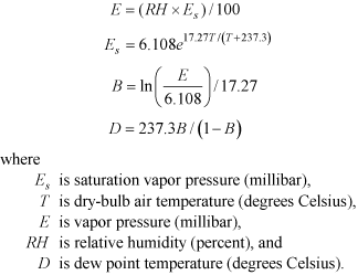
ResultsDissolved-Oxygen AugmentationBoth the “saturated” and “supersaturated” scenarios were effective at increasing dissolved-oxygen concentrations in the Link-Keno reach. The point of maximum effect on river dissolved-oxygen concentrations was immediately downstream of the saturation or injection point, and the effect decreased in the downstream direction as a result of consumption by decomposition and respiration processes as well as losses to the atmosphere for the supersaturated runs (fig. 16). Thus, if a specific location was targeted for dissolved oxygen improvement, the model predicts that the maximum benefit would be achieved by locating the saturation or injection point at or just upstream of that location. This differs from the wetland treatment scenarios, where the point of greatest dissolved oxygen improvement was some distance downstream of the treatment location. Although these dissolved-oxygen saturation and injection treatments were effective at increasing dissolved-oxygen concentrations, the model predicted that the effect on other water-quality constituents in the reach would be modest (tables A11, A12). This scenario did not change the source of the low-dissolved-oxygen conditions; it simply addressed and masked one of the outcomes by raising dissolved-oxygen concentrations. The model did predict minor increases in nitrate concentrations under these treatments, which was likely because more oxygenated conditions favored that form of dissolved nitrogen. Saturating the water column at Miller Island (segment 38) generally improved reach-average June-October dissolved-oxygen concentrations more than saturating the river at the two upstream locations (table A12) in the 4 years modeled. This likely is because the Miller Island location often has some of the lowest dissolved-oxygen concentrations in the reach, which allowed the most dissolved oxygen to be added through the reaeration process. In 3 of the 4 years modeled, the supersaturated runs indicated that of the three modeled injection locations, the site at Highway 97 (segment 21) increased June–October dissolved oxygen concentrations in the Link-Keno reach by the greatest amount. The simulated maximum dissolved‑oxygen concentration for the supersaturated injection at Miller Island sometimes was greater than the maximum results for the other two locations (fig. 16, August 1 results), probably because river flows at that site were lower, because it is downstream of the Lost River Diversion Channel withdrawal. The supersaturated scenarios were predicted to produce dissolved‑oxygen concentrations in excess of saturation at the injection location. If this type of treatment were used, the Link-Keno model could be used to assist with optimizing the treatment specifics to allow the maximum benefit, while eliminating excess oxygen treatment when not necessary. The model also could be used to help optimize the reaeration/saturation treatment, because these exploratory runs assumed the entire river reaches saturation, although it may be more realistic to attain such conditions for only parts of the water column or river. ShadingEven with the simulation of dense 65.6 ft (20 m) trees along the entire Link-Keno reach, the predicted cooling effect was modest, with an average temperature decrease of less than 0.6°C through the reach for June–October (table A14). The amount of cooling increased from upstream to downstream reaches due to the cumulative effect of shade along the entire reach (fig. 17). Other water-quality constituents that might be affected by shade, and the resulting decreased water temperature and less light for photosynthesis, revealed only minor effects in these simulations. Average concentrations of dissolved oxygen, ammonia, nitrate, chlorophyll a, particulate organic carbon, dissolved organic carbon, total nitrogen, total phosphorus, and pH were predicted to remain unchanged or to decrease slightly (tables A13, A14). Average concentrations of orthophosphorus were predicted to increase, but by an insignificant amount. The simulation of 65.6 ft (20 m) trees with dense canopies along the entire reach was an end member simulation used to examine what might be the maximum possible effects of vegetative shading. More realistic amounts of possible tree density, height, and extent would produce even smaller water temperature and water-quality effects. The effect of shade on the Link-Keno reach was limited, primarily because the relatively wide river channel is much wider than the shade cast by vegetation typical to the area. Scenario 10. Climate Change Effects on Water QualityScenario 10 explored possible water-quality effects of a future warmer climate on the Link-Keno reach. Predicted air temperature increases were derived from Global Circulation Model (GCM) results, downscaled for the Klamath Basin. These predicted future temperatures were used to adjust the Link-Keno model meteorological conditions and boundary inflow water temperatures. MethodsPredicted future air temperature changes were derived from five future GCM climate scenarios, which were simulated as part of a recent Klamath River dam removal study (Bureau of Reclamation, 2011; King and others, 2011). As part of that study, precipitation and air temperature predictions from five GCMs were downscaled to the upper and lower Klamath River basin. Hydrologic and meteorological conditions were forecast under the different climate change scenarios for a future period of 50 years. In the dam removal study, the downscaled precipitation and air temperature results provided input to a watershed scale hydrologic model, SAC-SMA, which estimated future hydrologic runoff to be used by two hydrologic decision models. Input hydrology for the two decision models was monthly, and daily flows were disaggregated for the downstream daily model using an approach that matched historical seasonal hydrology. The climate and Klamath dam removal study examined management alternatives under current operations with dams in-place and under the full Klamath Basin Restoration Agreement (Klamath Basin Restoration Agreement, 2010) with four downstream dams removed; Link and Keno Dams would remain in-place. For this study focusing on the Link-Keno reach of the Klamath River, future air temperature, dew point temperature, and water temperature of inflows were estimated based on the GCM-predicted annual average air temperature changes (maximum, median, minimum) between the base period 2006–09 and the future period 2057–60. Over 50 years, future air temperature was predicted to increase in all GCM simulations, although the amount of temperature change varied between simulations. The Link-Keno model for calendar year 2007 was selected as the base model for this scenario, although any of the 4 years could have been used. FlowsInitial plans for these model runs were to apply the hydrologic outputs of the climate change models to the Link‑Keno CE-QUAL-W2 models. For several reasons, however, climate change flows were not used, but base scenario conditions (base case) flows were used. The first reason to retain the base-case flows was that hydrologic conditions predicted for the Link-Keno reach were relatively similar in current and future years. The dam removal study hydrologic results illustrated that year-to-year flow differences were often greater than the overall flow change from the base case years to the future 50-year period. For example, Keno Dam outflows for the CE-QUAL-W2 2006–09 models were plotted with the 2012–60 monthly flows (fig. 18) from one of the downscaled GCM models (Canadian Centre for Climate Modeling Analysis, using the 75th precipitation quantile; other GCM models that use 50 or 25 percent precipitation percentiles would simulate drier years than the CCCMA model). The general seasonal patterns in flow were similar for the base-case and future years predicted by the GCM. On an annual average basis, the range of flows for future years 2057–60 and for base years 2006–09 were similar, with the range simulated for the entire period of 2012–60 including both wetter and drier conditions (fig. 19). Another reason to retain the base-case flows is that serious challenges exist in using second-generation hydrologic data from a model that had different objectives, and spatial and temporal resolution. For instance, the monthly time step for flow in the dam removal study (Bureau of Reclamation, 2011) was much longer than the 30-minute to daily time step used for CE-QUAL-W2 input. Additionally, the future flow operations model was not used to manage diversions and return flows or storage (assumed constant) in the Link-Keno reach, but instead was used for long-term planning horizon studies at the basin scale. The Link-Keno CE-QUAL-W2 modeling (Sullivan and others, 2011) focused on a specific reach, examining water quality responses on short timescales in longitudinal and vertical detail. If future CE-QUAL-W2 climate change scenarios include altered flows, consideration of these smaller-scale hydrologic conditions will be important before using hydrologic results from available climate change models. For these reasons, this climate change analysis focuses only on the effects of air temperature change and the related meteorological and water-quality changes. Meteorological ConditionsUsing output from all five GCMs, a minimum, median, and maximum annual average air temperature change for the Link-Keno reach was determined between 2006–09 and 2057–60 (table 13). Three model runs were constructed by increasing the measured hourly air temperatures for the Link-Keno reach for 2007 by these minimum (10a), median (10b), and maximum (10c) annual average air temperature changes. For these three runs, the dew point temperature for model input was recalculated assuming that relative humidity would remain unchanged in the future period, and air temperature was increased by the minimum, median, and maximum changes. For the base-case year 2007, relative humidity was calculated using dew point temperature and air temperature inputs. These dew point temperature calculations used equations from Snyder and Shaw (1984):
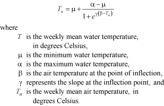
Water QualityWater temperature boundary conditions were updated after the meteorological changes were implemented. Procedures similar to those used by Perry and others (2011) were applied, with use of the Mohseni equation (Mohseni and others, 1998) to predict future water temperature. First, weekly average air temperatures for the entire reach and weekly average water temperature for Link River, Lost River Diversion Channel, and Klamath Straits Drain were calculated, consistent with the Mohseni equation. Subsequently, the weekly average air and water temperatures for the base case years were used to develop individual Mohseni equation parameters for each inflow:
Similar to Perry and others (2011), the parameter μ was set to 0°C and then α, β, and γ were estimated by a non-linear regression method for Link River, Lost River Diversion Channel, and Klamath Straits Drain using data from the base-case years 2006–09. Separate equations and Mohseni parameters were fit to the rising and falling limb time periods, the part of the year when air temperature tends to increase or decrease, for each of the three locations. For example, in 2007, air temperature generally increased through early July and decreased thereafter. After obtaining the best-fit parameters from the nonlinear regression model, measured weekly mean water temperature was plotted against weekly mean air temperature along with results from the fitted Mohseni equations for the rising and falling limbs of air temperature for the three locations. The fitted equations for the rising and falling limbs were quite similar for the Link River and Lost River Diversion Channel, so a single equation was used for those boundaries (table 14, fig. 20). After the Mohseni equations were derived for Link River, Lost River Diversion Channel and Klamath Straits Drain, future weekly averaged water temperatures were estimated using the estimated future air temperature. To obtain future hourly water temperature, the difference between weekly averaged base year water temperature and weekly averaged future year water temperature was added to or subtracted from the base year hourly water temperatures. Considering anthropogenic influence on point sources and their relatively small flows, water temperature for point sources were not estimated for the future years. Base-case values for those sources were used in these climate change scenarios. ResultsWater temperatures in the Link-Keno reach consistently increased under the warmer future climate condition scenario. In summer, the trend of increasing water temperature was expressed throughout the entire Link-Keno reach (fig. 21). The minimum (10a) air temperature increase of 0.86°C with associated dew point temperature and inflow water temperature changes led to an annual average water temperature increase of 0.6°C for the Link-Keno reach as an annual volume-average result (table A15). The median (10b) air temperature increase of 1.99°C led to an annual average water temperature increase of 1.4°C. The maximum (10c) air temperature increase of 3.25°C led to a water temperature increase of 2.4°C. These increases in water temperature could increase risks to key threatened and endangered fish species, depending on the time of year. Because dissolved-oxygen solubility decreases with increased water temperature, dissolved-oxygen concentrations were decreased under a warmer future condition, as much as 0.3 mg/L as an annual volume-average under the conditions examined here. Model results revealed only minor changes in other water-quality constituents (tables A15, A16). Scenario 10 focused on direct effects of temperature changes in the Link-Keno reach. Climate change also could affect water-quality conditions and phytoplankton composition of Upper Klamath Lake and Lost River watersheds, thus changing the inflow water quality of Link River, Lost River Diversion Channel, and Klamath Straits Drain. Water quality of inflows was not adjusted in this study, except for temperature. Future model scenarios could explore how other possible climate change effects could affect water quality in the Link-Keno reach. |
First posted July 24, 2013 For additional information contact: Part or all of this report is presented in Portable Document Format (PDF); the latest version of Adobe Reader or similar software is required to view it. Download the latest version of Adobe Reader, free of charge. |
||||||||||||||

![]() U.S. Department of the Interior |
U.S. Geological Survey
U.S. Department of the Interior |
U.S. Geological Survey
URL: http://pubsdata.usgs.gov/pubs/sir/2013/5135/section3.html
Page Contact Information: GS Pubs Web Contact
Page Last Modified: Monday, 22-Jul-2013 19:27:15 EDT

 (1)
(1)
 (2)
(2)