Geographic Analysis and Monitoring Program
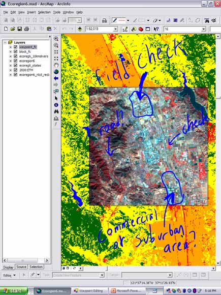
Map annotation using Tablet PC digital pen technology (from figure 16).
Understanding the rates, driving forces, and consequences of land-use and land-cover change is critical to the study of coupled human-environmental systems and in the ability of land-use managers to effectively manage natural resources. To support these needs, the U.S. Geological Survey (USGS) Land Cover Trends project seeks to (1) estimate the rates of land-cover change between 1972 and 2000, (2) document the regional driving forces of land-cover change, (3) determine the consequences of contemporary land-cover change, and (4) prepare regional and national syntheses of late-20th century land-cover and land-use change. Using an ecoregion stratification, researchers estimate land-cover change by mapping land cover in randomly selected 10-km by 10-km sample blocks of satellite data for five dates centered around 1973, 1980, 1986, 1992, and 2000 (Loveland and others 2002, Stehman, 2003).
In addition to estimating land-cover change for the sample blocks within an ecoregion, researchers conduct fieldwork to better understand local and regional driving forces and potential consequences of this change. At field sites within each sample block, researchers record qualitative observations in a notebook, collect global-positioning-system (GPS) waypoints, and take photographs. Hardcopy prints of imagery, road maps, and other ancillary geospatial data are used for navigation and for field annotations. Field trips last from one day to one week, with an average length of 5 days. Following fieldwork, researchers spend many hours entering field data, photographs, and map annotations into a digital database summarizing each ecoregion. The final database includes information for each field visit on geographic location, waypoint, sample block number, photograph roll and frame identification, ecoregion identification, and a landscape description.
Field data collection and database management is a significant task for the Land Cover Trends project, due to the national scope of the project and the high number of researchers involved from various USGS science centers. As such, any efforts to increase the efficiency of data collection and accessibility of research findings could have significant research and logistical benefits. Potential areas for increasing efficiency in the Land Cover Trends project include (1) minimizing the amount of hardcopy materials needed in the field while increasing the ability to view spatial data, (2) minimizing the amount of people required for fieldwork, (3) eliminating potential transcription errors when researchers transfer field notes into digital formats, (4) decreasing the amount of time required for postfieldwork data processing, and (5) increasing the accessibility of collected information for the Land Cover Trends research community.
An extension module to add specialized functionality to geographic information system (GIS) software was created to reduce field logistics and postfieldwork processing in the Land Cover Trends research project. The extension module developed to support the Land Cover Trends project, hereafter called the Trends extension, is designed to be used in the field on mobile computing technology platforms, such as tablet-based personal computers (tablet PCs) for data collection, and in the office on desktop computers for database management. This report summarizes extension installation, methods for its use in the field, and the benefits of its use for researchers.
In addition to supporting the Land Cover Trends research project, this extension was developed to demonstrate the benefits of mobile-computing technology in (1) minimizing logistical and postfieldwork data processing issues related to USGS fieldwork, (2) furthering the use of geospatial information in USGS field research efforts, and (3) in leveraging the existing USGS investment in GIS technology. Logistical issues related to fieldwork and postfieldwork data processing identified in this report are not unique to the USGS Land Cover Trends project and are common issues in many field research efforts of the USGS, We believe integrated packages of GPS, GIS, and mobile-computing technology, like the one described in this report, are applicable to other field research efforts at the USGS, and similar extensions can be developed elsewhere to support USGS research efforts.
Download this report as a 27-page PDF file (tm11c1.pdf; 1.4 MB)
For questions about the content of this report, contact Nate Wood
Download a copy of the latest version of Adobe Reader for free.
|
Help |
PDF help |
Publications main page |
| Western Techniques and Methods |
| Geography | Geographic Analysis and Monitoring Program
|

![]() U.S. Department of the Interior |
U.S. Geological Survey
U.S. Department of the Interior |
U.S. Geological Survey
URL: https://pubs.usgs.gov/tm/2006/tm11c1/
Page Contact Information: Michael Diggles
Page Last Modified: May 2, 2008
