Techniques and Methods 6D1
U.S. GEOLOGICAL SURVEY
Chapter 1 of
Section D, Ground-Water/Surface-Water
Book 6, Modeling Techniques
By Steven L. Markstrom, Richard G. Niswonger, R. Steven Regan, David E. Prudic, and Paul M. Barlow
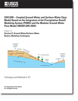
The need to assess the effects of variability in climate, biota, geology, and human activities on water availability and flow requires the development of models that couple two or more components of the hydrologic cycle. An integrated hydrologic model called GSFLOW (Ground-water and Surface-water FLOW) was developed to simulate coupled ground-water and surface-water resources. The new model is based on the integration of the U.S. Geological Survey Precipitation-Runoff Modeling System (PRMS) and the U.S. Geological Survey Modular Ground-Water Flow Model (MODFLOW). Additional model components were developed, and existing components were modified, to facilitate integration of the models. Methods were developed to route flow among the PRMS Hydrologic Response Units (HRUs) and between the HRUs and the MODFLOW finite-difference cells. This report describes the organization, concepts, design, and mathematical formulation of all GSFLOW model components. An important aspect of the integrated model design is its ability to conserve water mass and to provide comprehensive water budgets for a location of interest. This report includes descriptions of how water budgets are calculated for the integrated model and for individual model components. GSFLOW provides a robust modeling system for simulating flow through the hydrologic cycle, while allowing for future enhancements to incorporate other simulation techniques.
Preface
Abstract
Introduction
Design of GSFLOW
Cascading-Flow Procedure
Computations of Flow
Water Budgets
Assumptions And Limitations
Input and Output Files
Example Problem Sagehen Creek Watershed
Acknowledgments
References Cited
Appendix 1. Input Instructions for GSFLOW
Appendix 2. Definitions of Symbols
This report is available online in Portable Document Format (PDF). If you do not have the Adobe Acrobat PDF Reader, it is available for free download from Adobe Systems Incorporated.
Document Accessibility: Adobe Systems Incorporated has information about PDFs and the visually impaired. This information provides tools to help make PDF files accessible. These tools convert Adobe PDF documents into HTML or ASCII text, which then can be read by a number of common screen-reading programs that synthesize text as audible speech. In addition, an accessible version of Adobe Reader 8.0 for Windows (English only), which contains support for screen readers, is available. These tools and the accessible reader may be obtained free from Adobe at Adobe Access.
Send questions or comments about this report to the author, S.L. Markstrom, (303) 236-3330.

![]() U.S. Department of the Interior |
U.S. Geological Survey
U.S. Department of the Interior |
U.S. Geological Survey
Persistent URL: https://pubs.usgs.gov/tm/tm6d1
Page Contact Information: Publications Team
Page Last Modified: Friday, 02-Dec-2016 15:48:18 EST
