![]()
![]()
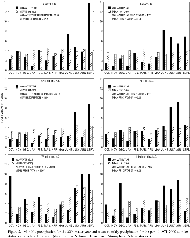
Despite the tropical systems affecting North Carolina during the 2004 water year, of the six key National Weather Service (NWS) precipitation stations (fig. 1 GIF/PDF), the Charlotte and Greensboro stations experienced below-average precipitation for the year; the four remaining sites recorded positive departures from average of less than 5 inches for the year (fig. 2 GIF/PDF). The NWS reported the following total annual precipitation amounts for the 2004 water year: Asheville, 51.80 inches (4.75 inches above average); Charlotte, 42.22 inches (1.29 inches below average); Greensboro, 35.84 inches (7.30 inches below average); Raleigh, 47.11 inches (4.06 inches above average); Wilmington, 60.71 inches (3.64 inches above average); and Elizabeth City, 52.66 inches (5.68 inches above average).
Precipitation amounts for the first quarter (October through December) of the 2004 water year were below average across the State except in Wilmington and Elizabeth City. Precipitation amounts in the western part of the State varied from 1.38 inches below average in Asheville to 5.53 inches below average in Charlotte, in the central part of the State from 1.24 inches below average in Raleigh to 3.28 inches below average in Greensboro, and in the eastern part of the State from 4.72 inches above average in Elizabeth City to 6.23 inches above average in Wilmington. Average precipitation amounts are mean monthly values based on data from 1971 through 2000, the 30-year base period used by the National Weather Service. Precipitation data recorded at two of the six key National Weather Service stations in the State (fig. 1 GIF/PDF) indicate that below-average precipitation amounts occurred in all months during the first quarter at Charlotte and Greensboro (fig. 2 GIF/PDF).
The second quarter of the 2004 water year (January through March) brought even drier conditions to the State. Precipitation was below average at all six index sites in January and March. The greatest precipitation amount recorded during the quarter was in Wilmington, but the total for the quarter remained 3.09 inches below average. Below-average precipitation for the quarter was recorded at Raleigh (3.66 inches), Asheville (5.43 inches), Greensboro (5.58 inches), and Charlotte (5.86 inches). Elizabeth City had the greatest deficit (6.28 inches below average) and the least amount of total precipitation (6.07 inches) during the second quarter.
The third quarter (April through June) brought above-average precipitation to the western and northeastern parts of the State. Elizabeth City had the greatest amount of precipitation during this period (3.63 inches above average); Charlotte and Asheville also had above-average precipitation (2.30 and 1.27 inches, respectively) in the western part of the State. Precipitation amounts ranged from 4.02 (Greensboro) and 0.62 (Raleigh) inches below average in the central part of the State to 4.88 inches below average in Wilmington in the southeastern part of the State. All six National Weather Service stations recorded below-average precipitation amounts in April in all three provinces of North Carolina.
During the fourth quarter (July through September), precipitation amounts were above average throughout the entire State, primarily as a result of an active hurricane season. The six index sites reported precipitation amounts ranging from 3.61 to 10.29 inches above average for the quarter—10.29 inches at Asheville, 7.80 inches at Charlotte, 5.58 inches at Greensboro, 9.58 inches at Raleigh, 5.38 inches at Wilmington, and 3.61 inches at Elizabeth City. During September 2004, high rainfall amounts from two hurricanes, Frances and Ivan, were recorded in several Blue Ridge counties in North Carolina. As much as 18 inches of rainfall was reported during a 5-day period (September 5–9) from Hurricane Frances, and as much as 9 inches of rainfall was reported during a 3-day period (September 16–18) from Hurricane Ivan (Neal Lott, National Oceanic and Atmospheric Administration, Asheville, N.C., written commun., 2004). The National Climatic Data Center indicated that the Asheville Regional Airport reported a new record for the wettest September and the wettest month ever, with a monthly precipitation total of 13.71 inches.
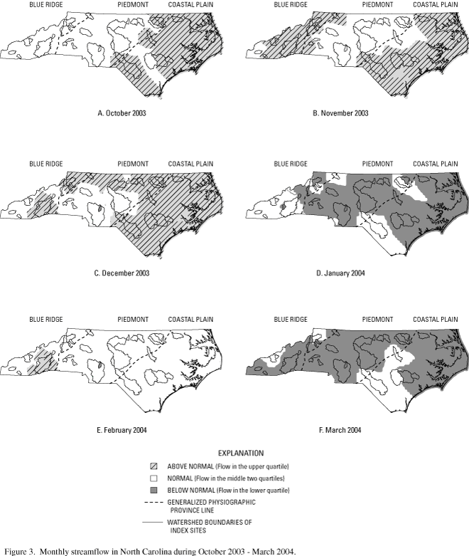
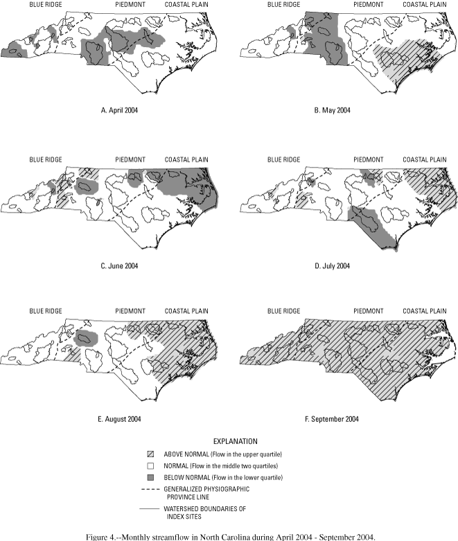
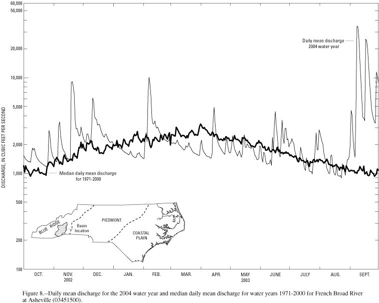
Streamflow conditions in North Carolina are influenced greatly by precipitation. Intense precipitation can produce rapid responses in streamflow. Streamflow also declines following periods of low precipitation. The rate and magnitude of these responses depend on basin size, shape, topography, geology, land cover, the season, evapotranspiration, and the amount of ground water in storage. The effects of variable precipitation on streamflow in North Carolina during the 2004 water year are illustrated in figures 3–8 (fig 3 GIF/PDF, fig 4 GIF/PDF, fig 5 GIF/PDF, fig 6 GIF/PDF, fig 7 GIF/PDF, fig 8 GIF/PDF).
Monthly conditions are depicted in maps (figs. 3 GIF/PDF and 4 GIF/PDF) that show the areas of above-normal, normal, and below-normal streamflow. Hydrographs of daily mean discharge for basins representing each of the three physiographic provinces of the State and the Sand Hills are shown in figures 5–8 (fig 5 GIF/PDF, fig 6 GIF/PDF, fig 7 GIF/PDF, fig 8 GIF/PDF). Data for the period of record from 34 index streamgaging stations across the State were used to compute monthly flow statistics (figs. 3 GIF/PDF and 4 GIF/PDF). These stations are located on streams that are free of significant regulations or diversions and range in size from about 30 to 1,400 square miles. "Above-normal" streamflow is flow in the upper quartile, "normal" streamflow is flow in the middle two quartiles, and "below-normal" refers to streamflow in the lower quartile.
Despite below-normal precipitation at index sites in central and western North Carolina during the first quarter (October through December) of the 2004 water year (fig. 3 GIF/PDF), all 34 index streamgaging stations recorded normal or above-normal streamflow conditions. During the period from January through March, streamflow decreased to below-normal or normal conditions as a result of deficient precipitation across the State, a condition that generally continued during the third quarter of the water year (April through June). The last quarter of the water year (July through September) was marked by increased tropical activity across the State, and much of the excess precipitation occurred during September in the Blue Ridge and western Piedmont Provinces. Precipitation associated with the remnants of Hurricane Frances early in September resulted in extensive flooding and new periodof- record peak streamflow at some gages in western North Carolina. Just over a week later, precipitation associated with the remnants of Hurricane Ivan brought additional flooding and, in some cases, eclipsed the previous peaks from Hurricane Frances. Many streamgages, particularly those in the Blue Ridge Province, recorded the highest monthly mean streamflow for the period of record and period-of-record peak river stage and streamflow. At 15 of the 34 index stations, record high monthly mean streamflow for September for the period of record was established. The combination of these two events over a short period of time resulted in widespread property damage from flooding.
![]()
Return to WY 2004 Annual Data Report Home Page
![]()